Bank nearby Energy Bank - 37 Branch
Ghana
Bank nearby Energy Bank - 37 Branch
Energy Bank - 37 Branch
Airport Area, Accra Ghana
contacts phone
:
+233
Latitude:
5.5904908
, Longitude:
-0.181439
read more
nearest Bank
18 m
Giosap Forex Bureau | Forex Bureau in Ghana | Forex Bureau in Accra
Liberation Road, Accra
Bank
read more
292 m
First Atlantic Bank
37 Liberation Road, First Floor, Max Mart, Accra
Bank
read more
575 m
FBN Bank - Airport Branch
Airport Residential Area, Accra
Bank
read more
575 m
FBN Bank - Airport Branch
Airport Area, Accra
Bank
read more
921 m
Standard Chartered Bank
Liberation Road, Accra
Bank
read more
922 m
Standard Chartered ATM - Opeibea
Liberation Road, Opposite Silver Star Towers, Accra
Bank
read more
927 m
Standard Chartered - Opeibea Branch
Liberation Road, Airport, Accra
Bank
read more
1.053 km
Barclays Bank
Accra
Bank
read more
1.056 km
Barclays Bank Airport Branch
North Liberation Link, Accra
Bank
read more
1.067 km
Stanbic Bank - Heights Branch
North Liberation Link, Accra
Bank
read more
1.069 km
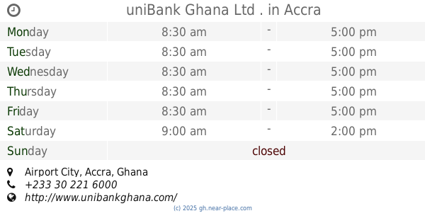
uniBank Ghana Ltd .
Airport City, Accra
Bank
read more
1.072 km
NIB Airport City Branch
Airport City, Accra
Bank
read more
1.18 km
prosperity alliance bank
Accra
Bank
read more
1.209 km
GT Bank Airport City
Accra
Bank
read more
1.211 km
FROM CITY BANK INTERNATIONAL
Accra
Bank
read more
1.319 km
UBA Ghana - Airport branch
No. 59 Patrice Lumumba Road, Accra
Bank
read more
1.517 km
SG Airport City Branch
Accra
Bank
read more
1.563 km
Ecobank
8 Quartey Papafio Avenue, Accra
Bank
read more
1.648 km
zenith bank
Patrice Lumumba Road, Accra
Bank
read more
1.679 km
ABii National Savings & Loans Mamobi Branch
Accra
Bank
read more
1.742 km
Dunia Microfinance
Al-Waleed bin Talal Highway, Accra
Bank
read more
2.204 km
Ecobank
Olusegun Obasanjo Way, Accra
Bank
read more
2.213 km
PBL Head Office
Ako Adjei Interchange, Accra
Bank
read more
2.513 km
UMB STOCKBROKERS
Accra
Bank
read more
Energy Bank - 37 Branch
Airport Residential Area, Accra
Bank
read more
📑
all categories
Accounting
Administrative area level 1
Administrative area level 2
Airport
Amusement park
Aquarium
Art gallery
Atm
Bakery
Bank
Bar
Beauty salon
Bicycle store
Book store
Bus station
Cafe
Campground
Car dealer
Car rental
Car repair
Car wash
Casino
Cemetery
Church
City hall
Clothing store
Colloquial area
Convenience store
Courthouse
Dentist
Department store
Doctor
Electrician
Electronics store
Embassy
Finance
Fire station
Florist
Food
Funeral home
Furniture store
Gas station
General contractor
Grocery or supermarket
Gym
Hair care
Hardware store
Health
Hindu Temple
Home goods store
Hospital
Insurance agency
Intersection
Jewelry store
Laundry
Lawyer
Library
Liquor store
Local government office
Locality
Locksmith
Lodging
Meal delivery
Meal takeaway
Mosque
Movie rental
Movie theater
Moving company
Museum
Natural feature
Neighborhood
Night club
Painter
Park
Parking
Pet store
Pharmacy
Physiotherapist
Place of worship
Plumber
Point of interest
Police
Post office
Premise
Real estate agency
Restaurant
Roofing contractor
Route
Rv park, camping
School
Shoe store
Shopping mall
Spa
Stadium
Storage
Store
Subpremise
Subway station
Supermarket
Synagogue
Taxi stand
Train station
Transit station
Travel agency
University
Veterinary care
Zoo
sublocality level 1
↑