Bank nearby National Investment Bank
Ghana
Bank nearby National Investment Bank
National Investment Bank
Nima, Accra Ghana
contacts phone
:
+233
Latitude:
5.5877396
, Longitude:
-0.2073358
read more
nearest Bank
12 m
Ocean Capital Microfinance Limited
New Town Road, Accra
Bank
read more
36 m
Societe Generale Ghana Accra New Town
1512 New Town Road, Accra
Bank
read more
167 m
Capital Bank
1516 New Town Road, Accra
Bank
read more
320 m
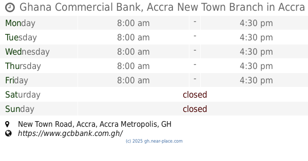
Ghana Commercial Bank, Accra New Town Branch
New Town Road, Accra
Bank
read more
330 m
GCB Bank - New Town Branch Michael Adjei
P.O BOX NT 96, Accra Newtown, New Town Road, Accra
Bank
read more
333 m
GCB Bank - New Town Branch
P.O BOX NT 96, Accra Newtown, New Town Road, Accra
Bank
read more
394 m
EcoBank Ghana - Kotobabi Branch
New Town Road, Accra
Bank
read more
575 m
Omni Bank
39 High Street, Accra
Bank
read more
576 m
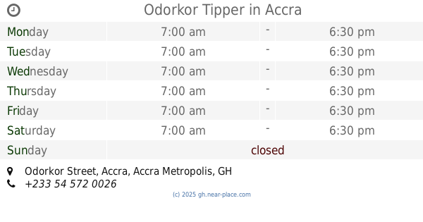
Odorkor Tipper
Odorkor Street, Accra
Bank
read more
581 m
Access Bank - Accra New Town Branch
Accra
Bank
read more
625 m
Bank Of Africa,Ghana.
Accra
Bank
read more
649 m
Stanbic Bank - Achimota
Achimota School Road, Achimota New Bus Terminal, Accra
Bank
read more
659 m
Ghana commercial Bank
Third School Road, Accra
Bank
read more
673 m
Go Express
Hill Street, Accra
Bank
read more
802 m
ADB Bank Newtown
Kokomlemle, Accra
Bank
read more
837 m
First African Savings & Loans Ltd.
New Town Road, Accra
Bank
read more
863 m
CCML, Malata Branch
Accra
Bank
read more
866 m
BestPoint Savings and Loan
Accra
Bank
read more
948 m
Stanbic Bank - Ring Road
Pyramid House, Opposite Nima Police Station, Nima, Accra
Bank
read more
948 m
ADB Bank - Nima Branch
Nima Mamobi Road, Near Nima Market, Accra
Bank
read more
958 m
Ecobank
Alajo Road, Accra
Bank
read more
983 m
GN Bank Malata Branch
Elephant Walk, Accra
Bank
read more
1.055 km
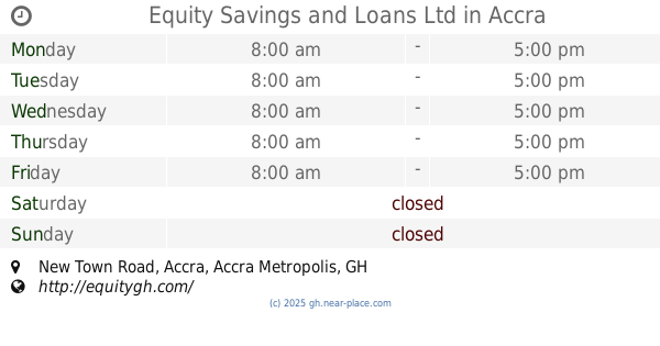
Equity Savings and Loans Ltd
New Town Road, Accra
Bank
read more
1.247 km
Cypress Microfinance Ltd.
62 Hotel Road, Accra
Bank
read more
1.33 km
First Atlantic Bank
Kotobabi Highway, Next to the Shell Fuel Station, Kotobabi
Bank
read more
📑
all categories
Accounting
Administrative area level 1
Administrative area level 2
Airport
Amusement park
Aquarium
Art gallery
Atm
Bakery
Bank
Bar
Beauty salon
Bicycle store
Book store
Bus station
Cafe
Campground
Car dealer
Car rental
Car repair
Car wash
Casino
Cemetery
Church
City hall
Clothing store
Colloquial area
Convenience store
Courthouse
Dentist
Department store
Doctor
Electrician
Electronics store
Embassy
Finance
Fire station
Florist
Food
Funeral home
Furniture store
Gas station
General contractor
Grocery or supermarket
Gym
Hair care
Hardware store
Health
Hindu Temple
Home goods store
Hospital
Insurance agency
Intersection
Jewelry store
Laundry
Lawyer
Library
Liquor store
Local government office
Locality
Locksmith
Lodging
Meal delivery
Meal takeaway
Mosque
Movie rental
Movie theater
Moving company
Museum
Natural feature
Neighborhood
Night club
Painter
Park
Parking
Pet store
Pharmacy
Physiotherapist
Place of worship
Plumber
Point of interest
Police
Post office
Premise
Real estate agency
Restaurant
Roofing contractor
Route
Rv park, camping
School
Shoe store
Shopping mall
Spa
Stadium
Storage
Store
Subpremise
Subway station
Supermarket
Synagogue
Taxi stand
Train station
Transit station
Travel agency
University
Veterinary care
Zoo
sublocality level 1
↑