Bank nearby Society Generale Ghana
Coronavirus disease (COVID-19) Situation
confirmed cases
171889
deaths
1462
Ghana
Bank nearby Society Generale Ghana
Society Generale Ghana
Star Avenue, Accra Ghana
contacts phone
:
+233
Latitude:
5.5737802
, Longitude:
-0.2060339
read more
nearest Bank
239 m
uniBank Head Office Annex
Royalt Castle Rd, Accra
Bank
read more
310 m
First Atlantic Bank - Ring Road Branch
Randolph House,, Ring Road Central, Accra
Bank
read more
317 m
Barclays Bank - Ring Road Branch
Accra
Bank
read more
352 m
Capital and More
Ring Road Central, Accra
Bank
read more
379 m
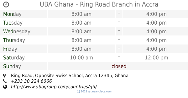
UBA Ghana - Ring Road Branch
Ring Road, Opposite Swiss School, Accra
Bank
read more
421 m
Trust Microfinance
Accra
Bank
read more
432 m
Ecobank - Ring Road Branch
Fidelity House, 20, Accra
Bank
read more
492 m
Jislah place
Wawa Road, Accra
Bank
read more
529 m
Stanbic Bank - Ring Road Branch
Accra
Bank
read more
529 m
Afro Arab Microfinance
Kokomlemle, Accra
Bank
read more
621 m
Adb Bank Ring Road Branch
Offin Avenue, Accra
Bank
read more
661 m
Cymain Capital Microfinance
Accra
Bank
read more
684 m
Access Bank Ghana Limited(Circle Branch)
Kokonte Street, Accra
Bank
read more
693 m
Access Bank
Ring Road Central, Accra
Bank
read more
814 m
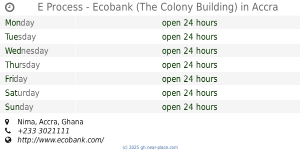
E Process - Ecobank (The Colony Building)
Nima, Accra
Bank
read more
832 m
Omnibank Kokomlemle
Faanofa Road, Accra
Bank
read more
849 m
First Bank Forex Bereau
Accra
Bank
read more
883 m
Omnibank
131 Faanofa Road, Accra
Bank
read more
912 m
Go Express
Hill Street, Accra
Bank
read more
938 m
CCML, Malata Branch
Accra
Bank
read more
996 m
Societe Generale Bank - Faanofa Branch
Faanofa Road, Accra
Bank
read more
1.007 km
ATM SGSSB
38 Faanofa Road, Accra
Bank
read more
1.09 km
First Atlantic Bank - North Ridge Branch
3 Dr. Isert Road, (Opposite Alisa Hotel), North Ridge, Accra
Bank
read more
1.18 km
CalBank
Kwame Nkrumah Avenue, Accra
Bank
read more
1.269 km
Global Access
Kwame Nkrumah Avenue, Accra
Bank
read more
📑
all categories
Accounting
Administrative area level 1
Administrative area level 2
Airport
Amusement park
Aquarium
Art gallery
Atm
Bakery
Bank
Bar
Beauty salon
Bicycle store
Book store
Bus station
Cafe
Campground
Car dealer
Car rental
Car repair
Car wash
Casino
Cemetery
Church
City hall
Clothing store
Colloquial area
Convenience store
Courthouse
Dentist
Department store
Doctor
Electrician
Electronics store
Embassy
Finance
Fire station
Florist
Food
Funeral home
Furniture store
Gas station
General contractor
Grocery or supermarket
Gym
Hair care
Hardware store
Health
Hindu Temple
Home goods store
Hospital
Insurance agency
Intersection
Jewelry store
Laundry
Lawyer
Library
Liquor store
Local government office
Locality
Locksmith
Lodging
Meal delivery
Meal takeaway
Mosque
Movie rental
Movie theater
Moving company
Museum
Natural feature
Neighborhood
Night club
Painter
Park
Parking
Pet store
Pharmacy
Physiotherapist
Place of worship
Plumber
Point of interest
Police
Post office
Premise
Real estate agency
Restaurant
Roofing contractor
Route
Rv park, camping
School
Shoe store
Shopping mall
Spa
Stadium
Storage
Store
Subpremise
Subway station
Supermarket
Synagogue
Taxi stand
Train station
Transit station
Travel agency
University
Veterinary care
Zoo
sublocality level 1
↑