Bar nearby Brotherhood Pub
Ghana
Bar nearby Brotherhood Pub
Brotherhood Pub
Madina, Ghana
contacts phone
:
+233 24 392 2080
website:
krmservicesgh.com
Latitude:
5.6423809
, Longitude:
-0.1357168
larger map & directions
read more
nearest Bar
516 m
The Godfather Bar & Grill
Unnamed Road, Accra
Bar
read more
830 m
Eddie's Pub
East Legon - Trasacco Estate Road, Accra
Bar
read more
971 m
Maudlor Rentals & DreamTree (Bar &Grill)
Madina
Bar
read more
1.078 km
Diamond's Pub & Grill
Sharp Curve, Boundary Road, Accra
Bar
read more
1.311 km
Ashquams Pub
Boundary Road, Accra
Bar
read more
1.412 km
Chez Amis
Shitor Street., Accra
Bar
read more
1.5 km
Sandy Spot
Spintex Road, Accra
Bar
read more
1.7 km
Famphy Spot
A&C Mall Jungle Road, Accra
Bar
read more
1.768 km
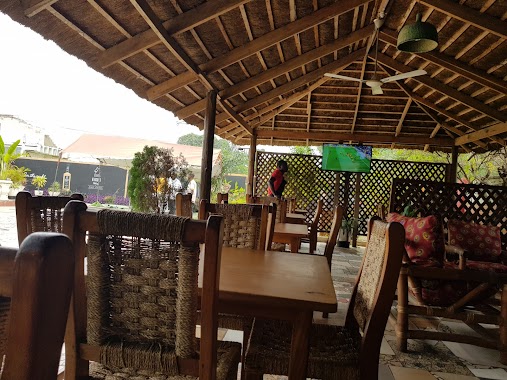
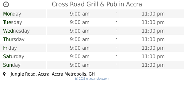
Cross Road Grill & Pub
Jungle Road, Accra
Bar
read more
1.782 km
Zeno's Yoghurt Bar
Jungle Road, Accra
Bar
read more
1.843 km
The Honeysuckle - A&C Mall Branch
Accra
Bar
read more
1.85 km
K Power Pub
Garden Road, Accra
Bar
read more
1.983 km
PIXXLES PUPLIC EAST LEGON
Accra
Bar
read more
2.025 km
Briefcase Bar
Accra
Bar
read more
2.149 km
Day Break( Taco Taco)
East Legon, Accra
Bar
read more
2.277 km
RoadHouse Grille
Boundary, Rd
Bar
read more
2.585 km
Vision Club
Accra
Bar
read more
2.639 km
Show Bar Ghana
69, Ogbojo Main Road, Madina
Bar
read more
2.928 km
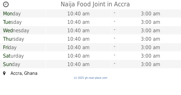
Naija Food Joint
Accra
Bar
read more
2.963 km
Yenkodi Bar & Restaurant
Corner of Mensah Wood Road & Opposite Ghana Link Services, Lagos Avenue, Accra
Bar
read more
2.985 km
The Field East Legon
Ogbodjo
Bar
read more
3.19 km
HASHTAG SPORTS BAR
Ghana
Bar
read more
3.295 km
The Ancient Pub
Unnamed Road, Accra
Bar
read more
3.323 km
Wepp's Place
Madina
Bar
read more
3.707 km
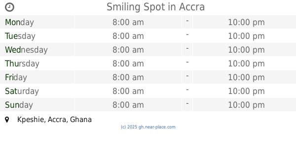
Smiling Spot
Accra
Bar
read more
📑
all categories
Accounting
Administrative area level 1
Administrative area level 2
Airport
Amusement park
Aquarium
Art gallery
Atm
Bakery
Bank
Bar
Beauty salon
Bicycle store
Book store
Bus station
Cafe
Campground
Car dealer
Car rental
Car repair
Car wash
Casino
Cemetery
Church
City hall
Clothing store
Colloquial area
Convenience store
Courthouse
Dentist
Department store
Doctor
Electrician
Electronics store
Embassy
Finance
Fire station
Florist
Food
Funeral home
Furniture store
Gas station
General contractor
Grocery or supermarket
Gym
Hair care
Hardware store
Health
Hindu Temple
Home goods store
Hospital
Insurance agency
Intersection
Jewelry store
Laundry
Lawyer
Library
Liquor store
Local government office
Locality
Locksmith
Lodging
Meal delivery
Meal takeaway
Mosque
Movie rental
Movie theater
Moving company
Museum
Natural feature
Neighborhood
Night club
Painter
Park
Parking
Pet store
Pharmacy
Physiotherapist
Place of worship
Plumber
Point of interest
Police
Post office
Premise
Real estate agency
Restaurant
Roofing contractor
Route
Rv park, camping
School
Shoe store
Shopping mall
Spa
Stadium
Storage
Store
Subpremise
Subway station
Supermarket
Synagogue
Taxi stand
Train station
Transit station
Travel agency
University
Veterinary care
Zoo
sublocality level 1
↑