Bar nearby Candy's Spot
Ghana
Bar nearby Candy's Spot
Candy's Spot
Haatso-Atomic Road, Accra, Accra Metropolis, GH Ghana
contacts phone
:
+233 27 744 6433
Latitude:
5.667822
, Longitude:
-0.1860595
larger map & directions
read more
nearest Bar
282 m
Tayiba Bar & Grill
Legon Botanical Gardens, Haatso-Atomic Road, Accra
Bar
read more
728 m
Adjei Mensah
4 Lemon Road
Bar
read more
815 m
Chilli Cabbanna Bar And Grill
6 Lemon Road
Bar
read more
901 m
Purple Rain
Agbogba - Ashongman Road, Accra
Bar
read more
926 m
Jemt Hot Bar
Ghana
Bar
read more
1.05 km
Contact Sports Bar & Restaurant
Ghana
Bar
read more
1.083 km
Timeless Bar & Restaurant
Kofi Annan Avenue, Madina
Bar
read more
1.105 km
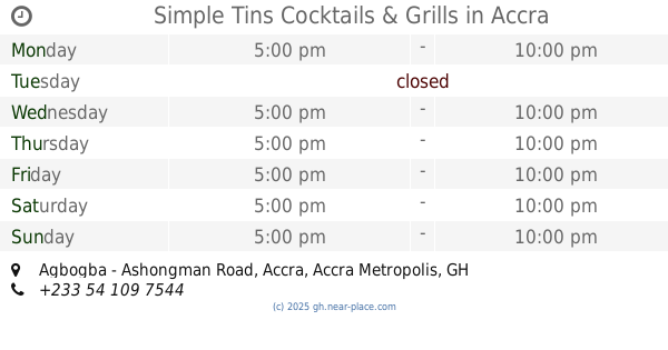
Simple Tins Cocktails & Grills
Agbogba - Ashongman Road, Accra
Bar
read more
1.11 km
Babito
Haatso
Bar
read more
1.305 km
Chin Chis Pub
Haatso-Atomic Road, Haatso
Bar
read more
1.313 km
Healing Your life Ceragem
Haatso
Bar
read more
1.399 km
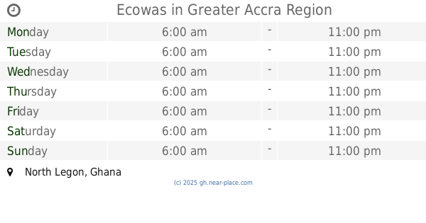
Ecowas
Bar
read more
1.593 km
Queen Tiaah's Pub
Haatso
Bar
read more
1.611 km
Queen Tiaah's Pub
Haatso-Atomic Road, Accra
Bar
read more
1.682 km
Happy Baby's
222 Haatso-Atomic Road, Accra
Bar
read more
1.711 km
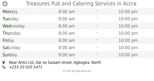
Treasures Pub and Catering Services
Treasures Pub, Near Antis Ltd, Dar es Salaam street, Agbogba, North Legon, Accra
Bar
read more
1.729 km
Goza's Palace Pub and Restaurant
Madina Zongo, Madina
Bar
read more
1.955 km
Legon Hall Lectures Bar
J. B. Danquah Road, Accra
Bar
read more
2.14 km
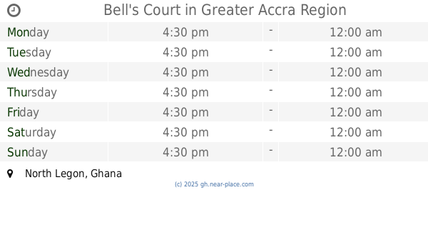
Bell's Court
Bar
read more
2.485 km
Staples Corner
Ecomog, Haatso
Bar
read more
2.517 km
Leatherwood Sports Pub
Madina
Bar
read more
2.594 km
Phillys Pub
Madina
Bar
read more
2.665 km
De Deep Pub
Ghana
Bar
read more
2.883 km
Thinkers Lounge (Members Only)
Madina
Bar
read more
3.596 km
Solo's Events Center
West Legon, Accra
Bar
read more
📑
all categories
Accounting
Administrative area level 1
Administrative area level 2
Airport
Amusement park
Aquarium
Art gallery
Atm
Bakery
Bank
Bar
Beauty salon
Bicycle store
Book store
Bus station
Cafe
Campground
Car dealer
Car rental
Car repair
Car wash
Casino
Cemetery
Church
City hall
Clothing store
Colloquial area
Convenience store
Courthouse
Dentist
Department store
Doctor
Electrician
Electronics store
Embassy
Finance
Fire station
Florist
Food
Funeral home
Furniture store
Gas station
General contractor
Grocery or supermarket
Gym
Hair care
Hardware store
Health
Hindu Temple
Home goods store
Hospital
Insurance agency
Intersection
Jewelry store
Laundry
Lawyer
Library
Liquor store
Local government office
Locality
Locksmith
Lodging
Meal delivery
Meal takeaway
Mosque
Movie rental
Movie theater
Moving company
Museum
Natural feature
Neighborhood
Night club
Painter
Park
Parking
Pet store
Pharmacy
Physiotherapist
Place of worship
Plumber
Point of interest
Police
Post office
Premise
Real estate agency
Restaurant
Roofing contractor
Route
Rv park, camping
School
Shoe store
Shopping mall
Spa
Stadium
Storage
Store
Subpremise
Subway station
Supermarket
Synagogue
Taxi stand
Train station
Transit station
Travel agency
University
Veterinary care
Zoo
sublocality level 1
↑