Bar nearby Jab's Shawarma Joint
Ghana
Bar nearby Jab's Shawarma Joint
Jab's Shawarma Joint
Patrice Lumumba Road, Accra, Accra Metropolis, GH Ghana
contacts phone
:
+233 23 333 3335
Latitude:
5.5658976
, Longitude:
-0.1807852
larger map & directions
read more
nearest Bar
76 m
Hemingway Bar
Oxford Street, Accra
Bar
read more
93 m
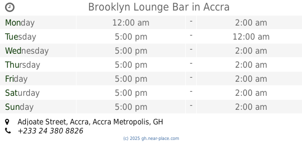
Brooklyn Lounge Bar
Adjoate Street, Accra
Bar
read more
197 m
Sharpnet Internet Cafe
Pink coloured two storey building opp Glory Oil fuel station, 19 Ring Road East. Open 24/7., Accra
Bar
read more
231 m
Firefly Lounge Bar
H P Nyemitei Street, Accra
Bar
read more
261 m
Friday's Spot Guest House & Sports Bar
Accra
Bar
read more
448 m
BJ's Sports Bar
Oxford Link 16th & 17th Ln Osu Near Central Hotel
Bar
read more
453 m
Kona Cafe & Grill
Oxford Street, Accra
Bar
read more
486 m
Sportsbet
Doctor Esther Ocloo Street, Accra
Bar
read more
611 m
The Republic Bar & Grill
Asafoatse Tempong Street, Accra
Bar
read more
616 m
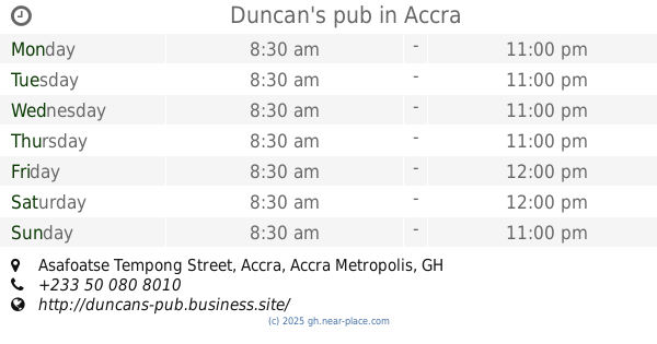
Duncan's pub
Asafoatse Tempong Street, Accra
Bar
read more
641 m
Serallio
Accra
Bar
read more
662 m
Summer Plus
Adzoatse Street, Accra
Bar
read more
674 m
Jema Enterprise
Asafoatse Tempong Street, Accra
Bar
read more
678 m
Zen Garden
Orphan Crescent, Labone, OS1937, Accra
Bar
read more
716 m
Container Pub
Accra
Bar
read more
771 m
Twist Night Club
Accra
Bar
read more
775 m
Buddies Sports Bar & Grill
Osu, Accra
Bar
read more
801 m
Koded Pub
Okodan Road, Accra
Bar
read more
862 m
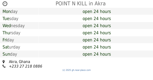
POINT N KILL
Accra
Bar
read more
868 m
KRAZY BAR & LOUNGE
Harry Sawyer Road, Accra
Bar
read more
926 m
Chester's Place Accra
407/5 Gbatsuna street, Nyaniba estates, osu, Accra
Bar
read more
949 m
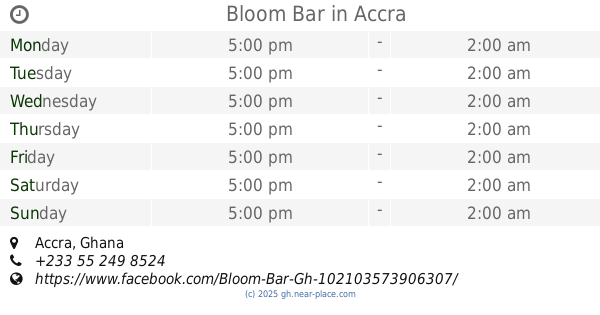
Bloom Bar
Accra
Bar
read more
1.023 km
vantage point
Nyaniba Road, Accra
Bar
read more
1.279 km
Alikoto Bar and Grill
Accra
Bar
read more
1.311 km
Smoke'n Barrel
42 dade st, labone, Accra
Bar
read more
📑
all categories
Accounting
Administrative area level 1
Administrative area level 2
Airport
Amusement park
Aquarium
Art gallery
Atm
Bakery
Bank
Bar
Beauty salon
Bicycle store
Book store
Bus station
Cafe
Campground
Car dealer
Car rental
Car repair
Car wash
Casino
Cemetery
Church
City hall
Clothing store
Colloquial area
Convenience store
Courthouse
Dentist
Department store
Doctor
Electrician
Electronics store
Embassy
Finance
Fire station
Florist
Food
Funeral home
Furniture store
Gas station
General contractor
Grocery or supermarket
Gym
Hair care
Hardware store
Health
Hindu Temple
Home goods store
Hospital
Insurance agency
Intersection
Jewelry store
Laundry
Lawyer
Library
Liquor store
Local government office
Locality
Locksmith
Lodging
Meal delivery
Meal takeaway
Mosque
Movie rental
Movie theater
Moving company
Museum
Natural feature
Neighborhood
Night club
Painter
Park
Parking
Pet store
Pharmacy
Physiotherapist
Place of worship
Plumber
Point of interest
Police
Post office
Premise
Real estate agency
Restaurant
Roofing contractor
Route
Rv park, camping
School
Shoe store
Shopping mall
Spa
Stadium
Storage
Store
Subpremise
Subway station
Supermarket
Synagogue
Taxi stand
Train station
Transit station
Travel agency
University
Veterinary care
Zoo
sublocality level 1
↑