Clothing store nearby The Asare's
Ghana
Clothing store nearby The Asare's
The Asare's
Ablekuma, Accra, Ghana
contacts phone
:
+233 26 999 0681
website:
www.gerablogblog.wordpress.com
Latitude:
5.5511744
, Longitude:
-0.2526163
larger map & directions
read more
nearest Clothing store
384 m
Rita Fashon
P.V. Obeng by Pass, Kumasi
Clothing store
read more
421 m
Maxxy Style
Dansoman Community Market Store D8, Dansoman Estates, Accra
Clothing store
read more
582 m
Nujifashion
Outer Ring Road, Accra
Clothing store
read more
723 m
Nanaba Garment and Trading ENT
Accra
Clothing store
read more
724 m
Angie's Kollections
Dansoman Market, Opposite Gold House, Accra
Clothing store
read more
781 m
Gina's Best-goodies parlour
dansoman, hansonic road
Clothing store
read more
820 m
Owia Clothing and Designs
Accra
Clothing store
read more
852 m
Kacy Clothing
Aharabata Street, Accra
Clothing store
read more
863 m
Verbiss Enterprise
P. O. Box 1037, Accra
Clothing store
read more
871 m
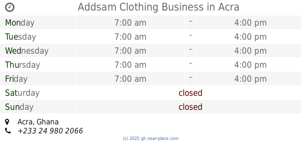
Addsam Clothing Business
Accra
Clothing store
read more
891 m
Mama Esther African Wear.
Ghana
Clothing store
read more
909 m
Cloth Bank
Oblogo Road, Accra
Clothing store
read more
915 m
Samuel Ofori Collections
Pentecost Dansoman
Clothing store
read more
955 m
Yawa Clothing
Ghana
Clothing store
read more
983 m
Af-Fro Wear
Oblogo Road, Accra
Clothing store
read more
998 m
Fashion Lounge Boutique
Banana inn
Clothing store
read more
1.005 km
Ken and Eu shop
Dansoman, Accra
Clothing store
read more
1.008 km
Ladies (Silas Boutique) Gents
Ghana
Clothing store
read more
1.047 km
Grabot Fashion Centre
Ghana
Clothing store
read more
1.061 km
Spark Beads
Sakumo Crescent, Accra
Clothing store
read more
1.118 km
Paradise Collections
Oblogo Road, Accra
Clothing store
read more
1.169 km
No Problem The Best T-Shirt
Ghana
Clothing store
read more
1.169 km
No Problem The Best T-Shirt
217 Oblogo Road, Accra
Clothing store
read more
1.266 km
Talk'n Apparel
1st Close, Accra
Clothing store
read more
1.303 km
Mandyz Place
Ablekuma
Clothing store
read more
📑
all categories
Accounting
Administrative area level 1
Administrative area level 2
Airport
Amusement park
Aquarium
Art gallery
Atm
Bakery
Bank
Bar
Beauty salon
Bicycle store
Book store
Bus station
Cafe
Campground
Car dealer
Car rental
Car repair
Car wash
Casino
Cemetery
Church
City hall
Clothing store
Colloquial area
Convenience store
Courthouse
Dentist
Department store
Doctor
Electrician
Electronics store
Embassy
Finance
Fire station
Florist
Food
Funeral home
Furniture store
Gas station
General contractor
Grocery or supermarket
Gym
Hair care
Hardware store
Health
Hindu Temple
Home goods store
Hospital
Insurance agency
Intersection
Jewelry store
Laundry
Lawyer
Library
Liquor store
Local government office
Locality
Locksmith
Lodging
Meal delivery
Meal takeaway
Mosque
Movie rental
Movie theater
Moving company
Museum
Natural feature
Neighborhood
Night club
Painter
Park
Parking
Pet store
Pharmacy
Physiotherapist
Place of worship
Plumber
Point of interest
Police
Post office
Premise
Real estate agency
Restaurant
Roofing contractor
Route
Rv park, camping
School
Shoe store
Shopping mall
Spa
Stadium
Storage
Store
Subpremise
Subway station
Supermarket
Synagogue
Taxi stand
Train station
Transit station
Travel agency
University
Veterinary care
Zoo
sublocality level 1
↑