Health nearby Scientellect Biomedical Laboratory
Coronavirus disease (COVID-19) Situation
confirmed cases
171889
deaths
1462
Ghana
Health nearby Scientellect Biomedical Laboratory
Scientellect Biomedical Laboratory
5.639672,-0.0588832,17z, Ghana
contacts phone
:
+233 30 297 1562
Latitude:
5.6396282
, Longitude:
-0.0566686
larger map & directions
read more
nearest Health
1.018 km
Care Unit First Aid Services
P.O.Box GP 4299 Accra, Huntington Drive, Sakumono
Health
read more
1.701 km
Well Care
Tema
Health
read more
1.762 km
Trust Clinic
Sakumono
Health
read more
1.778 km
Mercy Home Care Center
C13 PLT G160, Sakumono., Tema
Health
read more
1.804 km
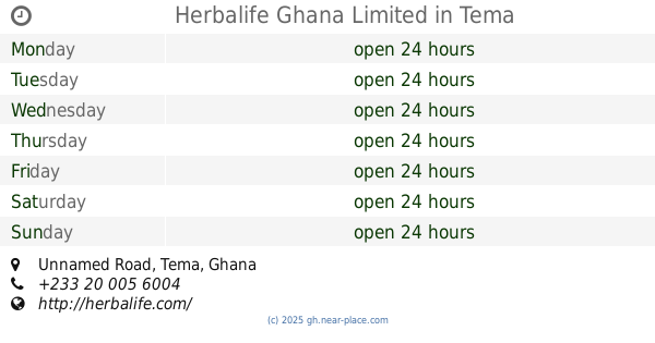
Herbalife Ghana Limited
Unnamed Road, Tema
Health
read more
1.83 km
Makay Pharmacy Ltd
Unnamed Road, Tema
Health
read more
1.834 km
Equilinks
Unnamed Road, Sakumono
Health
read more
1.845 km
EQUILINKS
Sakumono
Health
read more
1.921 km
Community 20 Spinal Clinic
Tema New Town
Health
read more
1.927 km
Spinal Clinic Limited
Moss Close
Health
read more
2.084 km
Nelmax Clinic
17 Eucalyptus Cl, Tema New Town
Health
read more
2.2 km
mobiMED Pharmacy Limited - Sakumono
Sakumono
Health
read more
2.239 km
Recovery Nutritionals Ltd
Community 16, Along Spintex Road, Lashibi
Health
read more
2.329 km
Nolan Pharmacy ltd
West Boundary Road community 18, Tema
Health
read more
2.381 km
VNVHEALTHCARE
Sakumono
Health
read more
2.432 km
Brobbson Pharmacy
Sakumono
Health
read more
2.555 km
AMASHA Optical Services
Ghana
Health
read more
2.625 km
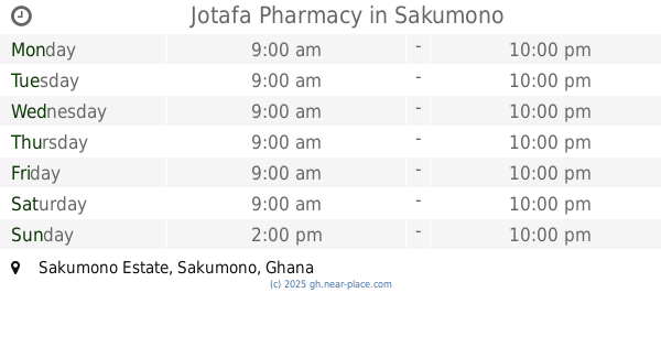
Jotafa Pharmacy
Sakumono Estate, Sakumono
Health
read more
2.861 km
Herbelle Pharmacy
Tema Metropolitan
Health
read more
2.899 km
ACO
Spintex Road, Accra
Health
read more
2.923 km
Millan Chemists Pharmacy
Accra
Health
read more
3.04 km
TINATETT HERBAL
Plot no. 48A, Spintex. Kotobabi, Accra
Health
read more
3.33 km
Crossroad Clinic
Reg Gray Est
Health
read more
3.395 km
Life Health Care - Junction Mall
Accra
Health
read more
3.588 km
Pharmaceutical Society Of Ghana Accra
Accra
Health
read more
📑
all categories
Accounting
Administrative area level 1
Administrative area level 2
Airport
Amusement park
Aquarium
Art gallery
Atm
Bakery
Bank
Bar
Beauty salon
Bicycle store
Book store
Bus station
Cafe
Campground
Car dealer
Car rental
Car repair
Car wash
Casino
Cemetery
Church
City hall
Clothing store
Colloquial area
Convenience store
Courthouse
Dentist
Department store
Doctor
Electrician
Electronics store
Embassy
Finance
Fire station
Florist
Food
Funeral home
Furniture store
Gas station
General contractor
Grocery or supermarket
Gym
Hair care
Hardware store
Health
Hindu Temple
Home goods store
Hospital
Insurance agency
Intersection
Jewelry store
Laundry
Lawyer
Library
Liquor store
Local government office
Locality
Locksmith
Lodging
Meal delivery
Meal takeaway
Mosque
Movie rental
Movie theater
Moving company
Museum
Natural feature
Neighborhood
Night club
Painter
Park
Parking
Pet store
Pharmacy
Physiotherapist
Place of worship
Plumber
Point of interest
Police
Post office
Premise
Real estate agency
Restaurant
Roofing contractor
Route
Rv park, camping
School
Shoe store
Shopping mall
Spa
Stadium
Storage
Store
Subpremise
Subway station
Supermarket
Synagogue
Taxi stand
Train station
Transit station
Travel agency
University
Veterinary care
Zoo
sublocality level 1
↑