Local government office nearby USAID Ghana Evaluate for Health Project
Ghana
Local government office nearby USAID Ghana Evaluate for Health Project
USAID Ghana Evaluate for Health Project
Abafun Crescent, Accra, Accra Metropolis, GH Ghana
contacts phone
:
+233
Latitude:
5.5717207
, Longitude:
-0.1661746
larger map & directions
read more
nearest Local government office
548 m
Jesus Is Mine Enterprise
Labone, Accra
Local government office
read more
743 m
CCM Ghana Secretariat
Accra
Local government office
read more
1.502 km
Awana National Office
Accra
Local government office
read more
1.505 km
Bangalores of Prison Service Personnel
Labone, Accra
Local government office
read more
1.532 km
Prison Officers Bangalores
Labone, Accra
Local government office
read more
1.834 km
Kaja-Tech Enterprise
5A Second Circular Road, Accra
Local government office
read more
1.859 km
Airport Zonal Council
Accra
Local government office
read more
2.025 km
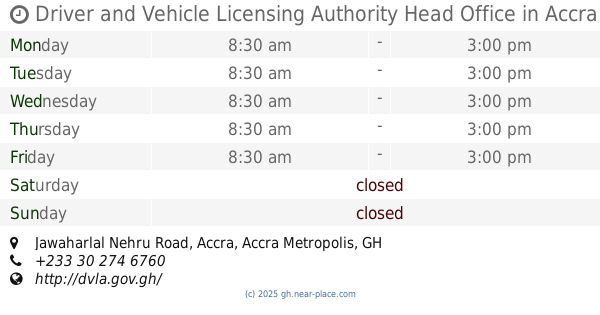
Driver and Vehicle Licensing Authority Head Office
Jawaharlal Nehru Road, Accra
Local government office
read more
2.034 km
My Office
Cantonments, Accra
Local government office
read more
2.089 km
Department Of Parks And Garden
Cantonments, Accra
Local government office
read more
2.171 km
Osu Trade Fair
2nd Lane, Accra
Local government office
read more
2.182 km
La Dade-Kotopon Municipal Assembly
Adjacent La Trade Fair Centre, Accra
Local government office
read more
2.306 km
Geo-tech Surveys Ltd
Accra
Local government office
read more
2.779 km
DVLA 37 OFFICE
Liberation Crescent, Accra
Local government office
read more
2.823 km
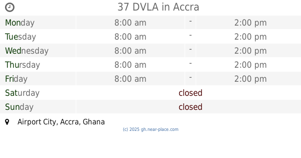
37 DVLA
Airport City, Accra
Local government office
read more
2.951 km
10 Bonsu Road
Basel Street, Accra
Local government office
read more
3.228 km
Ghana Investment Fund for Electronic Communications
North Ridge, Accra
Local government office
read more
3.237 km
Ministry of Communications
5°33'34.1"N 0°11'33., William Tubman Avenue, Accra
Local government office
read more
3.253 km
NADMO HQ ACCRA
E, Al Seka Al Hadid
Local government office
read more
3.284 km
Ayawaso East Sub Metro
East Kanda Road, Accra
Local government office
read more
4.423 km
MDPI Ghana
Victoria Borg, Accra
Local government office
read more
4.483 km
CSS PRECISE SYSTEMS LTD
Airport Area, Accra
Local government office
read more
4.54 km
Family Health Division
Accra
Local government office
read more
4.753 km
Accra Metropolitan Assembly New Office
Victoria Borg, Accra
Local government office
read more
4.931 km
Accra Metropolitan Assembly, Ayawaso Central Sub-Metro Office
New Town Road, Accra
Local government office
read more
📑
all categories
Accounting
Administrative area level 1
Administrative area level 2
Airport
Amusement park
Aquarium
Art gallery
Atm
Bakery
Bank
Bar
Beauty salon
Bicycle store
Book store
Bus station
Cafe
Campground
Car dealer
Car rental
Car repair
Car wash
Casino
Cemetery
Church
City hall
Clothing store
Colloquial area
Convenience store
Courthouse
Dentist
Department store
Doctor
Electrician
Electronics store
Embassy
Finance
Fire station
Florist
Food
Funeral home
Furniture store
Gas station
General contractor
Grocery or supermarket
Gym
Hair care
Hardware store
Health
Hindu Temple
Home goods store
Hospital
Insurance agency
Intersection
Jewelry store
Laundry
Lawyer
Library
Liquor store
Local government office
Locality
Locksmith
Lodging
Meal delivery
Meal takeaway
Mosque
Movie rental
Movie theater
Moving company
Museum
Natural feature
Neighborhood
Night club
Painter
Park
Parking
Pet store
Pharmacy
Physiotherapist
Place of worship
Plumber
Point of interest
Police
Post office
Premise
Real estate agency
Restaurant
Roofing contractor
Route
Rv park, camping
School
Shoe store
Shopping mall
Spa
Stadium
Storage
Store
Subpremise
Subway station
Supermarket
Synagogue
Taxi stand
Train station
Transit station
Travel agency
University
Veterinary care
Zoo
sublocality level 1
↑