Lodging nearby A & M Beach House
Ghana
Lodging nearby A & M Beach House
A & M Beach House
Kokrobite Street, Kokrobite, Accra Metropolis, GH Ghana
contacts phone
:
+233 54 374 2200
Latitude:
5.5356009
, Longitude:
-0.2466411
larger map & directions
read more
nearest Lodging
2 m
Best Atlantic Guesthouse Ltd
Kokrobite Street, Accra
Lodging
read more
187 m
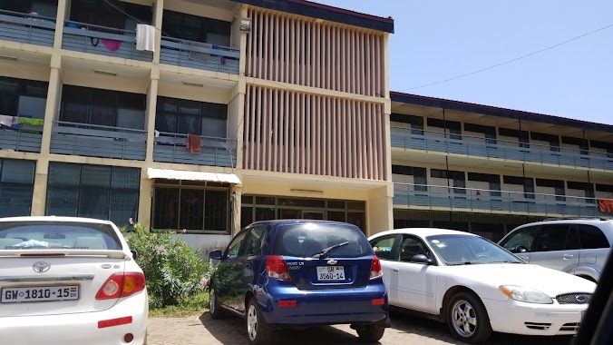
Church Of Pentecost_Mission House
Chorkor, Accra
Lodging
read more
239 m
Victory House
Chorkor, Accra
Lodging
read more
360 m
Tina's Millenium Hostel
Old Dansoman High Street, Accra
Lodging
read more
516 m
Kembs Hotel
Lartebiokorshie, Accra
Lodging
read more
578 m
Teeberg Hostel
Kpakpo Briamah Street, Accra
Lodging
read more
740 m
Santana Guest House
Chorkor, Accra
Lodging
read more
896 m
Ricardo's Hotel
Doctor Nanka Bruce Road, Accra
Lodging
read more
982 m
Comfort zone
Nsakina Street, Accra
Lodging
read more
1.088 km
old elta school
4th Sakumo Street, Accra
Lodging
read more
1.162 km
Stay Home Hotel
Banana Inn, Accra
Lodging
read more
1.234 km
Morte Mpata St
Dansoman, Accra
Lodging
read more
1.269 km
Naos Inn
Off South Odorkor Estate Road, Near Akokofoto, Dansoman
Lodging
read more
1.498 km
Golden Door Hostel
Lartebiokorshie, Accra
Lodging
read more
1.504 km
Mascot Hotel
Dansoman, Accra
Lodging
read more
1.585 km
Nuga's Cottage (Guest House)
Jonkobri Road, Accra
Lodging
read more
1.615 km
R-Block (Medical Students' Hostel)
Accra
Lodging
read more
1.621 km
Jehovah Inn
7th Sakumo Link, Accra
Lodging
read more
1.646 km
Good NIght Hotel
Accra
Lodging
read more
1.646 km
Mascot Hotel
Accra
Lodging
read more
1.962 km
Pescourt Hotel
Accra
Lodging
read more
2.081 km
Royal Dede Beach Resort
Old Winneba Road, Accra
Lodging
read more
2.275 km
Nurses And Midwives Hostel
Accra
Lodging
read more
2.342 km
SSNIT FLATS
Chief Lagbo Street, Accra
Lodging
read more
2.395 km
Naos Inn
HSE No A 52/20, Accra
Lodging
read more
📑
all categories
Accounting
Administrative area level 1
Administrative area level 2
Airport
Amusement park
Aquarium
Art gallery
Atm
Bakery
Bank
Bar
Beauty salon
Bicycle store
Book store
Bus station
Cafe
Campground
Car dealer
Car rental
Car repair
Car wash
Casino
Cemetery
Church
City hall
Clothing store
Colloquial area
Convenience store
Courthouse
Dentist
Department store
Doctor
Electrician
Electronics store
Embassy
Finance
Fire station
Florist
Food
Funeral home
Furniture store
Gas station
General contractor
Grocery or supermarket
Gym
Hair care
Hardware store
Health
Hindu Temple
Home goods store
Hospital
Insurance agency
Intersection
Jewelry store
Laundry
Lawyer
Library
Liquor store
Local government office
Locality
Locksmith
Lodging
Meal delivery
Meal takeaway
Mosque
Movie rental
Movie theater
Moving company
Museum
Natural feature
Neighborhood
Night club
Painter
Park
Parking
Pet store
Pharmacy
Physiotherapist
Place of worship
Plumber
Point of interest
Police
Post office
Premise
Real estate agency
Restaurant
Roofing contractor
Route
Rv park, camping
School
Shoe store
Shopping mall
Spa
Stadium
Storage
Store
Subpremise
Subway station
Supermarket
Synagogue
Taxi stand
Train station
Transit station
Travel agency
University
Veterinary care
Zoo
sublocality level 1
↑