Lodging nearby Asew Lodge
Ghana
Lodging nearby Asew Lodge
Asew Lodge
Sun City, Ghana
contacts phone
:
+233
Latitude:
5.6962982
, Longitude:
-0.1941551
larger map & directions
read more
nearest Lodging
217 m
COP Atinga Bio
Sun City
Lodging
read more
682 m
Proguesthouse
Block 35, Agbogba Grace Filling Station, North Legon
Lodging
read more
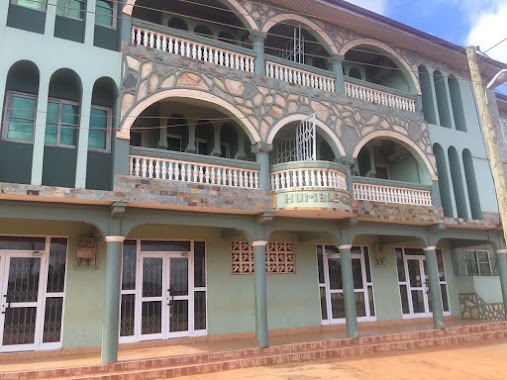
694 m
Humble Grace Guest House
Haatso-Atomic Road, Accra
Lodging
read more
754 m
Elegance Guest House
Lodging
read more
878 m
Check Attio Guest House
Agbogba
Lodging
read more
986 m
Weema Hostel
Norwood City
Lodging
read more
1.087 km
Wisconsin Hostel
Ghana
Lodging
read more
1.121 km
Ecstacy Royal Hotel
Ghana
Lodging
read more
1.182 km
Life Camp Hotel
Ritz Junction on the Ecowas Rd, near Agboba Police Station, Ecowas Road
Lodging
read more
1.188 km
El-Virtues estate
Ghana
Lodging
read more
1.25 km
Pebble Pine Hotel
Ghana
Lodging
read more
1.339 km
J&J Hostel Adenta Sakora
Adenta Municipality
Lodging
read more
1.418 km
Wisconsin International Hostel
Cosway Street
Lodging
read more
1.431 km
Nabegyi Hotel
Agbogba
Lodging
read more
1.534 km
Kobby's Hotel
Anum Street, Madina
Lodging
read more
1.606 km
Idyllic Moments Guest House
Ghana
Lodging
read more
1.78 km
Acacia guest Lodge
Haatso
Lodging
read more
1.839 km
HanPrince Lodge
Adenta, West
Lodging
read more
1.951 km
Jayliz Lodge
No. 113, Angel View Residential Area, Adenta West, Adenta
Lodging
read more
1.975 km
Travellers Palm Court
Agbogba - Ashongman Road, Agbogba
Lodging
read more
1.984 km
Ashongman
Ghana
Lodging
read more
1.99 km
nanas holiday let guest house
Nii Tempon Street, ghana
Lodging
read more
2.174 km
International Students Hostel Ghana (ISHG)
Abokobi Road, Accra
Lodging
read more
2.331 km
The Green Hostel
Haatso
Lodging
read more
2.464 km
Bethel Heights Hotel
Redco, Madina
Lodging
read more
📑
all categories
Accounting
Administrative area level 1
Administrative area level 2
Airport
Amusement park
Aquarium
Art gallery
Atm
Bakery
Bank
Bar
Beauty salon
Bicycle store
Book store
Bus station
Cafe
Campground
Car dealer
Car rental
Car repair
Car wash
Casino
Cemetery
Church
City hall
Clothing store
Colloquial area
Convenience store
Courthouse
Dentist
Department store
Doctor
Electrician
Electronics store
Embassy
Finance
Fire station
Florist
Food
Funeral home
Furniture store
Gas station
General contractor
Grocery or supermarket
Gym
Hair care
Hardware store
Health
Hindu Temple
Home goods store
Hospital
Insurance agency
Intersection
Jewelry store
Laundry
Lawyer
Library
Liquor store
Local government office
Locality
Locksmith
Lodging
Meal delivery
Meal takeaway
Mosque
Movie rental
Movie theater
Moving company
Museum
Natural feature
Neighborhood
Night club
Painter
Park
Parking
Pet store
Pharmacy
Physiotherapist
Place of worship
Plumber
Point of interest
Police
Post office
Premise
Real estate agency
Restaurant
Roofing contractor
Route
Rv park, camping
School
Shoe store
Shopping mall
Spa
Stadium
Storage
Store
Subpremise
Subway station
Supermarket
Synagogue
Taxi stand
Train station
Transit station
Travel agency
University
Veterinary care
Zoo
sublocality level 1
↑