Lodging nearby Blue Royal Hotel (Adabraka)
Ghana
Lodging nearby Blue Royal Hotel (Adabraka)
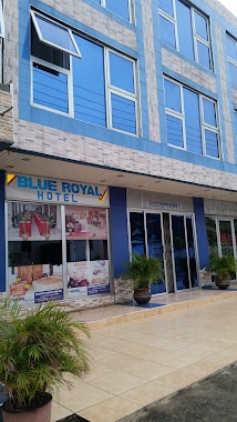
Blue Royal Hotel (Adabraka)
Castle Road, Accra, Accra Metropolis, GH Ghana
contacts phone
:
+233 30 220 1934
Latitude:
5.5606299
, Longitude:
-0.2128249
larger map & directions
read more
nearest Lodging
151 m
Evandy Hostel, Adabraka
Accra
Lodging
read more
228 m
Shobby Hostel
Angetebu Road, Accra
Lodging
read more
320 m
Tesano Cottage
Cliff Street, Accra
Lodging
read more
346 m
Denne Hostel
West Ridge, Accra
Lodging
read more
349 m
Hotel Avenida
Kojo Thompson Road, Accra
Lodging
read more
363 m
Ingot Hotel
Accra
Lodging
read more
364 m
St. Georges Hotel
Chartfield Avenue, Accra
Lodging
read more
504 m
Niagara Inn
Ofoli Kpakpo Road, Accra
Lodging
read more
631 m
City Apartments Hotel
Ghana
Lodging
read more
643 m
Niagara Hotel
Farrar Avenue, Accra
Lodging
read more
669 m
Ashaiman
Castle Road, Accra
Lodging
read more
704 m
Hotel President
Accra
Lodging
read more
729 m
Teachers Hall GNAT
Accra
Lodging
read more
776 m
Millenium Guest House
Accra
Lodging
read more
828 m
Calvary Methodist Church Guest House
Tsiranana, Accra
Lodging
read more
879 m
Beverly Hills Hotel
17 Samora Machel, Accra
Lodging
read more
914 m
Eltonim Hostel
Tudu, Accra
Lodging
read more
918 m
Efa Gardens
Accra
Lodging
read more
970 m
Traveller's Paradise Hotel
Tudu Crescent, Accra
Lodging
read more
994 m
Bellview Hotel
Tudu Crescent, Accra
Lodging
read more
1.022 km
Tropical Breeze Guest House
Accra
Lodging
read more
1.041 km
Time Square Lodge
Accra
Lodging
read more
1.091 km
Pacific Farms Hotel
Klagon Tema, Community 19
Lodging
read more
1.166 km
Sempe Villa
32 Samora Machel Road, Accra
Lodging
read more
1.301 km
Accra City Hotel
Barnes Road, Accra
Lodging
read more
📑
all categories
Accounting
Administrative area level 1
Administrative area level 2
Airport
Amusement park
Aquarium
Art gallery
Atm
Bakery
Bank
Bar
Beauty salon
Bicycle store
Book store
Bus station
Cafe
Campground
Car dealer
Car rental
Car repair
Car wash
Casino
Cemetery
Church
City hall
Clothing store
Colloquial area
Convenience store
Courthouse
Dentist
Department store
Doctor
Electrician
Electronics store
Embassy
Finance
Fire station
Florist
Food
Funeral home
Furniture store
Gas station
General contractor
Grocery or supermarket
Gym
Hair care
Hardware store
Health
Hindu Temple
Home goods store
Hospital
Insurance agency
Intersection
Jewelry store
Laundry
Lawyer
Library
Liquor store
Local government office
Locality
Locksmith
Lodging
Meal delivery
Meal takeaway
Mosque
Movie rental
Movie theater
Moving company
Museum
Natural feature
Neighborhood
Night club
Painter
Park
Parking
Pet store
Pharmacy
Physiotherapist
Place of worship
Plumber
Point of interest
Police
Post office
Premise
Real estate agency
Restaurant
Roofing contractor
Route
Rv park, camping
School
Shoe store
Shopping mall
Spa
Stadium
Storage
Store
Subpremise
Subway station
Supermarket
Synagogue
Taxi stand
Train station
Transit station
Travel agency
University
Veterinary care
Zoo
sublocality level 1
↑