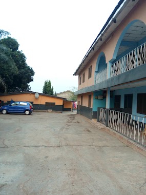
Lodging nearby French Hostel
Ghana
Lodging nearby French Hostel
French Hostel
akweteman, Achimota Road, Accra Ghana
contacts phone
:
+233
Latitude:
5.613146
, Longitude:
-0.2379146
read more
nearest Lodging
264 m
Adogate Executive Lodge
Kingsby round about, Akweteymang, Accra
Lodging
read more
297 m
SAN GIORGIO HOTEL
Akweteyman
Lodging
read more
303 m
BROWN HOSTEL
Akweteyman
Lodging
read more
393 m
Ajope Lodge
Pumpkin Avenue, Akweteyman
Lodging
read more
398 m
Green Ice Hotel
P.O Box AN 11013, Accra
Lodging
read more
429 m
la royal beach hotel
George W Bush Highway, Accra
Lodging
read more
487 m
Residence Eagle Vision
Akweteyman
Lodging
read more
579 m
Seasons Resort Beach And Hotel
Achimota, Accra
Lodging
read more
633 m
Sue's Royal Cottage
Tesano, Accra
Lodging
read more
655 m
O'Adom Lodge Hotel
Kwame Nkrumah Motorway, Lapaz Nii Boi Town, Off Achimota Highway, Akweteyman, Accra
Lodging
read more
782 m
Santana Hotel Accra
Accra
Lodging
read more
818 m
Vanderpuye's Lodge
Pumpkin Avenue, Accra
Lodging
read more
844 m
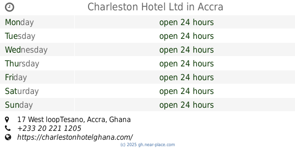
Charleston Hotel Ltd
17 West loopTesano, Accra
Lodging
read more
924 m
FAIRWINDS HOTEL
Accra
Lodging
read more
1.007 km
Ace Pit Stop
Abeka Junction, Tesano
Lodging
read more
1.13 km
Akokoraba Hostel
Ghana
Lodging
read more
1.14 km
Babylon Gardens
Tesano, Accra
Lodging
read more
1.143 km
Brookvale Hotel
Sampa Valley, Kasoa
Lodging
read more
1.152 km
Kwabeksco Hotel (Accra)
Lapaz Main Traffic Light, Near Lass-Palmas, Accra
Lodging
read more
1.174 km
Shaky's Hotel Achimota
Accra
Lodging
read more
1.254 km
Kinsby Hotel
Ghana
Lodging
read more
1.443 km
Lincoln Hotel
Kinsby Junction, Neoplan station, Achimota
Lodging
read more
1.634 km
Kings Premier Lodge
16th Street New, Achimota
Lodging
read more
1.67 km
Naa Akuyea Lodge
Market Close, Accra
Lodging
read more
1.95 km
GTUC International Students'Hostel
Tesano, Accra
Lodging
read more
📑
all categories
Accounting
Administrative area level 1
Administrative area level 2
Airport
Amusement park
Aquarium
Art gallery
Atm
Bakery
Bank
Bar
Beauty salon
Bicycle store
Book store
Bus station
Cafe
Campground
Car dealer
Car rental
Car repair
Car wash
Casino
Cemetery
Church
City hall
Clothing store
Colloquial area
Convenience store
Courthouse
Dentist
Department store
Doctor
Electrician
Electronics store
Embassy
Finance
Fire station
Florist
Food
Funeral home
Furniture store
Gas station
General contractor
Grocery or supermarket
Gym
Hair care
Hardware store
Health
Hindu Temple
Home goods store
Hospital
Insurance agency
Intersection
Jewelry store
Laundry
Lawyer
Library
Liquor store
Local government office
Locality
Locksmith
Lodging
Meal delivery
Meal takeaway
Mosque
Movie rental
Movie theater
Moving company
Museum
Natural feature
Neighborhood
Night club
Painter
Park
Parking
Pet store
Pharmacy
Physiotherapist
Place of worship
Plumber
Point of interest
Police
Post office
Premise
Real estate agency
Restaurant
Roofing contractor
Route
Rv park, camping
School
Shoe store
Shopping mall
Spa
Stadium
Storage
Store
Subpremise
Subway station
Supermarket
Synagogue
Taxi stand
Train station
Transit station
Travel agency
University
Veterinary care
Zoo
sublocality level 1
↑