Lodging nearby Hotel De Doris
Ghana
Lodging nearby Hotel De Doris
Hotel De Doris
Ga East, Ghana
contacts phone
:
+233
Latitude:
5.7334286
, Longitude:
-0.2165538
larger map & directions
read more
nearest Lodging
1.433 km
Abokobi Presbyterian Women's Centre
Ghana
Lodging
read more
1.465 km
Guest Villa
Ghana
Lodging
read more
1.655 km
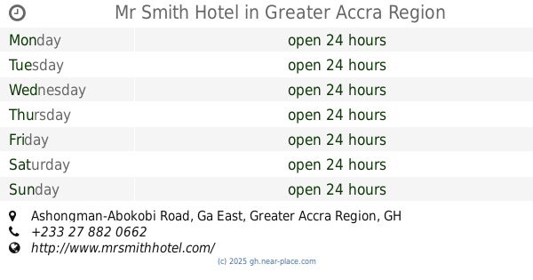
Mr Smith Hotel
Ashongman-Abokobi Road
Lodging
read more
2.526 km
El-Virtues Estate
Pantang West
Lodging
read more
2.668 km
International Students Hostel Ghana (ISHG)
Abokobi Road, Accra
Lodging
read more
2.695 km
Regal Palm Villa Hotel Guest House
Saint Johns - Dome - Kwabenya - Brekusu Road, Accra
Lodging
read more
2.778 km
New Student Hostels
Todd and Ruth Warren Library, 1 University Avenue
Lodging
read more
2.797 km
Student Hostel
1 University Avenue
Lodging
read more
2.983 km
Oscars Hostel
Lodging
read more
3.002 km
Nananom Hostel
Ghana
Lodging
read more
3.041 km
Travellers Palm Court
Agbogba - Ashongman Road, Agbogba
Lodging
read more
3.155 km
Isgc
Lodging
read more
3.177 km
Columbiana
University Avenue
Lodging
read more
3.19 km
INTERNATIONAL STUDENT GUEST CENTER
Lodging
read more
3.291 km
El-Virtues Estates
Ghana
Lodging
read more
3.403 km
Oyarifa White House
Lodging
read more
3.984 km
Burger Town Guest House
Ghana
Lodging
read more
4.02 km
Manak Heights Apartments
Ghana
Lodging
read more
4.633 km
Crystal Rock Hotel
Kwakwranya Street Oyarifa, Accra
Lodging
read more
5.527 km
J&J Hostel Adenta Sakora
Adenta Municipality
Lodging
read more
5.773 km
HanPrince Lodge
Adenta, West
Lodging
read more
5.784 km
Kobby's Hotel
Anum Street, Madina
Lodging
read more
6.16 km
Jolee Guest House
Kumasi Road, Behind Lucky Filling Station, GA East, Kwabenya
Lodging
read more
6.431 km
Grace Inn Hotel
Kwabenya-Pokuase Road, Kwabenya
Lodging
read more
6.435 km
Jayliz Lodge
No. 113, Angel View Residential Area, Adenta West, Adenta
Lodging
read more
📑
all categories
Accounting
Administrative area level 1
Administrative area level 2
Airport
Amusement park
Aquarium
Art gallery
Atm
Bakery
Bank
Bar
Beauty salon
Bicycle store
Book store
Bus station
Cafe
Campground
Car dealer
Car rental
Car repair
Car wash
Casino
Cemetery
Church
City hall
Clothing store
Colloquial area
Convenience store
Courthouse
Dentist
Department store
Doctor
Electrician
Electronics store
Embassy
Finance
Fire station
Florist
Food
Funeral home
Furniture store
Gas station
General contractor
Grocery or supermarket
Gym
Hair care
Hardware store
Health
Hindu Temple
Home goods store
Hospital
Insurance agency
Intersection
Jewelry store
Laundry
Lawyer
Library
Liquor store
Local government office
Locality
Locksmith
Lodging
Meal delivery
Meal takeaway
Mosque
Movie rental
Movie theater
Moving company
Museum
Natural feature
Neighborhood
Night club
Painter
Park
Parking
Pet store
Pharmacy
Physiotherapist
Place of worship
Plumber
Point of interest
Police
Post office
Premise
Real estate agency
Restaurant
Roofing contractor
Route
Rv park, camping
School
Shoe store
Shopping mall
Spa
Stadium
Storage
Store
Subpremise
Subway station
Supermarket
Synagogue
Taxi stand
Train station
Transit station
Travel agency
University
Veterinary care
Zoo
sublocality level 1
↑