Lodging nearby The Florence Hotel - Accra
Ghana
Lodging nearby The Florence Hotel - Accra
The Florence Hotel - Accra
15 Odaw Street, Accra Ghana
contacts phone
:
+233
Latitude:
5.5757706
, Longitude:
-0.205952
read more
nearest Lodging
36 m
The Florence Accra
15 Odaw Street, Accra
Lodging
read more
127 m
HORAK HOTEL
Accra
Lodging
read more
185 m
Somewhere Nice
9,, Cotton Avenue, Accra
Lodging
read more
216 m
Accra Central View Hotel
Accra
Lodging
read more
222 m
New Kokomlemle Guest House
Accra
Lodging
read more
329 m
Acquah Place - Short Stay Apartments
Kokomlemle, Accra
Lodging
read more
351 m
Paloma Hotel Ring Road Central
11 Ringway Close, Accra
Lodging
read more
378 m
Movie House Plaza Kokomlemle
Abele Road, Accra
Lodging
read more
456 m
Hotel C'est Si Bon Kokomlemle
Royalt Castle Road, Accra
Lodging
read more
510 m
Ampax Hotel - Asylum Down
Asylum Down Roundabout, Asylum Down
Lodging
read more
552 m
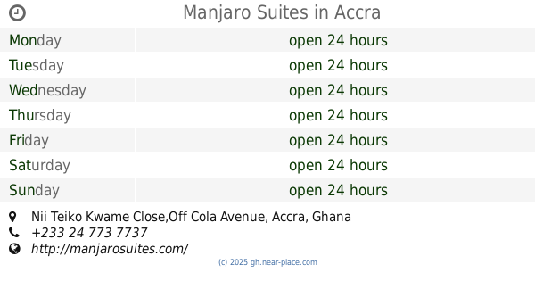
Manjaro Suites
Nii Teiko Kwame Close,Off Cola Avenue
Lodging
read more
585 m
Building in Construction
Accra
Lodging
read more
640 m
Ampaqx Grand Hotel
5 TH CRESCENT & OKUKUSEKU RD ACCRA
Lodging
read more
669 m
Gye Nyame Hotel
3rd Mango Tree Avenue, Accra
Lodging
read more
697 m
Korkdam Hotel
Nyadji Crescent, Accra
Lodging
read more
731 m
Vitara Hotel
New Town Road, Accra
Lodging
read more
745 m
City Centre guest House
Mango Tree Avenue, Accra
Lodging
read more
763 m
Highgate Hotel
70 Mango Tree Avenue, Accra
Lodging
read more
928 m
New Town Hostel
Accra
Lodging
read more
934 m
Efa Gardens
Accra
Lodging
read more
972 m
Ruby Kay Hotel
U.P.S Road, ARS roundabout, Accra
Lodging
read more
974 m
Freeman Hostel
24 Odorkor Street, Accra
Lodging
read more
1.011 km
Georgetown Court
Sakou Toure Street, North Ridge, Accra
Lodging
read more
1.032 km
Frankies Annex Nima A
Justin Street, Accra
Lodging
read more
1.241 km
The Post Lodge
Accra
Lodging
read more
📑
all categories
Accounting
Administrative area level 1
Administrative area level 2
Airport
Amusement park
Aquarium
Art gallery
Atm
Bakery
Bank
Bar
Beauty salon
Bicycle store
Book store
Bus station
Cafe
Campground
Car dealer
Car rental
Car repair
Car wash
Casino
Cemetery
Church
City hall
Clothing store
Colloquial area
Convenience store
Courthouse
Dentist
Department store
Doctor
Electrician
Electronics store
Embassy
Finance
Fire station
Florist
Food
Funeral home
Furniture store
Gas station
General contractor
Grocery or supermarket
Gym
Hair care
Hardware store
Health
Hindu Temple
Home goods store
Hospital
Insurance agency
Intersection
Jewelry store
Laundry
Lawyer
Library
Liquor store
Local government office
Locality
Locksmith
Lodging
Meal delivery
Meal takeaway
Mosque
Movie rental
Movie theater
Moving company
Museum
Natural feature
Neighborhood
Night club
Painter
Park
Parking
Pet store
Pharmacy
Physiotherapist
Place of worship
Plumber
Point of interest
Police
Post office
Premise
Real estate agency
Restaurant
Roofing contractor
Route
Rv park, camping
School
Shoe store
Shopping mall
Spa
Stadium
Storage
Store
Subpremise
Subway station
Supermarket
Synagogue
Taxi stand
Train station
Transit station
Travel agency
University
Veterinary care
Zoo
sublocality level 1
↑