Pharmacy nearby Avenue Chemist
Ghana
Pharmacy nearby Avenue Chemist
Avenue Chemist
10th Avenue, Accra, Accra Metropolis, GH Ghana
contacts phone
:
+233 30 222 8247
Latitude:
5.5973733
, Longitude:
-0.2295146
larger map & directions
read more
nearest Pharmacy
160 m
Bamel Pharmacy
10th Avenue, Accra
Pharmacy
read more
429 m
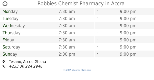
Robbies Chemist Pharmacy
Tesano, Accra
Pharmacy
read more
471 m
3A Health Pharm Ltd.
30 Mukose Street, Accra
Pharmacy
read more
471 m
3A Health Pharm Ltd.
Ghana
Pharmacy
read more
794 m
Addpharma Retail - North Industrial Area
Reberrson Crescent, Accra
Pharmacy
read more
1.377 km
Rophi Pharmacy
Ghana
Pharmacy
read more
1.42 km
Pyxis Systems
Second Close Palace, Palace Street, Accra
Pharmacy
read more
1.507 km
Josly Pharmacy Ltd.
Ghana
Pharmacy
read more
1.536 km
Imorich Enterprise
Accra
Pharmacy
read more
1.545 km
Medcare Pharmacy
Fadama Road, Accra
Pharmacy
read more
1.57 km
Elsheen Pharma Ltd.
Ghana
Pharmacy
read more
1.57 km
AD Pharmacy
North Industrial Area, Accra
Pharmacy
read more
1.588 km
Enie Chemist Limited
Paradise Crescent, Accra
Pharmacy
read more
1.844 km
Matt-Mill Pharmacy
Primpongwe Street, Accra
Pharmacy
read more
1.966 km
Free Mart Pharmacy
Palace Street, Accra
Pharmacy
read more
2.056 km
Dufie Chemicals
Accra
Pharmacy
read more
2.149 km
Op Pharmacy
Ghana
Pharmacy
read more
2.223 km
Right Pharmacy
Ghana
Pharmacy
read more
2.539 km
Unichem Industries Limited
Bubuashie,, Agbon Boi Street, Accra
Pharmacy
read more
2.579 km
Endurance Pharmacy Ltd
Ghana
Pharmacy
read more
2.663 km
Lab-aid
Accra
Pharmacy
read more
2.703 km
Flexta Pharmacy
Agbon Boi Street, Accra
Pharmacy
read more
2.833 km
Stevako Pharmacy Ltd.
Alajo High Street, Accra
Pharmacy
read more
3.288 km
Lifeline Chemists
Nii Amasa Street, Accra
Pharmacy
read more
3.861 km
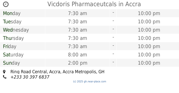
Vicdoris Pharmaceutcals
Ring Road Central, Accra
Pharmacy
read more
📑
all categories
Accounting
Administrative area level 1
Administrative area level 2
Airport
Amusement park
Aquarium
Art gallery
Atm
Bakery
Bank
Bar
Beauty salon
Bicycle store
Book store
Bus station
Cafe
Campground
Car dealer
Car rental
Car repair
Car wash
Casino
Cemetery
Church
City hall
Clothing store
Colloquial area
Convenience store
Courthouse
Dentist
Department store
Doctor
Electrician
Electronics store
Embassy
Finance
Fire station
Florist
Food
Funeral home
Furniture store
Gas station
General contractor
Grocery or supermarket
Gym
Hair care
Hardware store
Health
Hindu Temple
Home goods store
Hospital
Insurance agency
Intersection
Jewelry store
Laundry
Lawyer
Library
Liquor store
Local government office
Locality
Locksmith
Lodging
Meal delivery
Meal takeaway
Mosque
Movie rental
Movie theater
Moving company
Museum
Natural feature
Neighborhood
Night club
Painter
Park
Parking
Pet store
Pharmacy
Physiotherapist
Place of worship
Plumber
Point of interest
Police
Post office
Premise
Real estate agency
Restaurant
Roofing contractor
Route
Rv park, camping
School
Shoe store
Shopping mall
Spa
Stadium
Storage
Store
Subpremise
Subway station
Supermarket
Synagogue
Taxi stand
Train station
Transit station
Travel agency
University
Veterinary care
Zoo
sublocality level 1
↑