Restaurant nearby Harvest Restaurant
Ghana
Restaurant nearby Harvest Restaurant
Harvest Restaurant
Located within Jempat Hotel Ghana
contacts phone
:
+233
Latitude:
5.6997729
, Longitude:
-0.1747084
read more
nearest Restaurant
391 m
Baritas Restaurant
N4, Madina
Restaurant
read more
772 m
Barita's Chinese and Pizza Takeaway Joint
Adenta barrier
Restaurant
read more
827 m
KFC Adenta Shell Filling Station
Lame Dwaahe Street, Adenta Municipality
Restaurant
read more
1.101 km
Daavi’s Kitchen
Adenta Municipality
Restaurant
read more
1.114 km
Sunkwa Fast Food
Ghana
Restaurant
read more
1.179 km
Put Your Trust In God
Adenta Municipality
Restaurant
read more
1.216 km
NaCl SISI BISTRO
Ghana
Restaurant
read more
1.285 km
Shop n Save Supermarker
Ghana
Restaurant
read more
1.426 km
Mama gee food
Norwood City
Restaurant
read more
1.524 km
Mama T Fast Food
Ghana
Restaurant
read more
1.602 km
Zainabs Swallow
Madina
Restaurant
read more
1.659 km
La Bella Napoli Bar and Restaurant
Shalom Junction Road, Adenta Municipality
Restaurant
read more
1.719 km
Adenta Kenkey
Adenta Municipality
Restaurant
read more
1.784 km
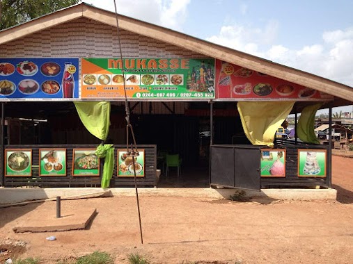
MUKASSE RESTURANT/FOOD JOINT
Redco Flats, Legon East Road, Madina
Restaurant
read more
1.841 km
Tasty Chow Resturant
Adenta, Adenta Municipality
Restaurant
read more
1.925 km
RosyLand
Adenta Municipality
Restaurant
read more
1.958 km
ALL BAR ONE RESTAURANT
Ghana
Restaurant
read more
1.96 km
All Bar One Restaurant
North Legon
Restaurant
read more
1.977 km
Medina Ritz Hotel
Madina
Restaurant
read more
2.014 km
African Kitchen
Madina
Restaurant
read more
2.148 km
Area Corner Pub
Madina
Restaurant
read more
2.226 km
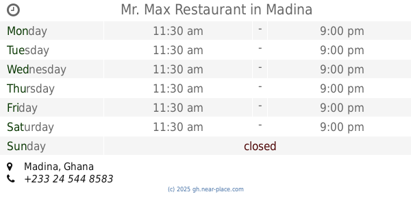
Mr. Max Restaurant
Madina
Restaurant
read more
2.23 km
Africa Mama Fast Food
Ghana
Restaurant
read more
2.26 km
Milani Fast Food
Madina
Restaurant
read more
2.272 km
JUST FREDDIES
Adenta Municipality
Restaurant
read more
📑
all categories
Accounting
Administrative area level 1
Administrative area level 2
Airport
Amusement park
Aquarium
Art gallery
Atm
Bakery
Bank
Bar
Beauty salon
Bicycle store
Book store
Bus station
Cafe
Campground
Car dealer
Car rental
Car repair
Car wash
Casino
Cemetery
Church
City hall
Clothing store
Colloquial area
Convenience store
Courthouse
Dentist
Department store
Doctor
Electrician
Electronics store
Embassy
Finance
Fire station
Florist
Food
Funeral home
Furniture store
Gas station
General contractor
Grocery or supermarket
Gym
Hair care
Hardware store
Health
Hindu Temple
Home goods store
Hospital
Insurance agency
Intersection
Jewelry store
Laundry
Lawyer
Library
Liquor store
Local government office
Locality
Locksmith
Lodging
Meal delivery
Meal takeaway
Mosque
Movie rental
Movie theater
Moving company
Museum
Natural feature
Neighborhood
Night club
Painter
Park
Parking
Pet store
Pharmacy
Physiotherapist
Place of worship
Plumber
Point of interest
Police
Post office
Premise
Real estate agency
Restaurant
Roofing contractor
Route
Rv park, camping
School
Shoe store
Shopping mall
Spa
Stadium
Storage
Store
Subpremise
Subway station
Supermarket
Synagogue
Taxi stand
Train station
Transit station
Travel agency
University
Veterinary care
Zoo
sublocality level 1
↑