Restaurant nearby Njoy Salad
Coronavirus disease (COVID-19) Situation
confirmed cases
171889
deaths
1462
Ghana
Restaurant nearby Njoy Salad
Njoy Salad
Titus Street, Accra Ghana
contacts phone
:
+233
Latitude:
5.5370469
, Longitude:
-0.2587141
read more
nearest Restaurant
329 m
Golden Palace
28th Street, Accra
Restaurant
read more
424 m
Rami's Food
26th Close, Accra
Restaurant
read more
553 m
Christie's Food Joint
Nsakina Street, Accra
Restaurant
read more
684 m
McQueens Cafe & Catering Services
Chorkor, Accra
Restaurant
read more
693 m
Summer Kiss Restaurant
Dansoman, Accra
Restaurant
read more
721 m
Peevees Food Palace
15 21st Close, Accra
Restaurant
read more
733 m
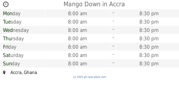
Mango Down
Accra
Restaurant
read more
779 m
Perez Kitchen
Dansoman High Street, Accra
Restaurant
read more
802 m
The Royal Eatery
Dansoman Datus road
Restaurant
read more
811 m
Reggie's Kitchen
Old Dansoman High Street, Accra
Restaurant
read more
847 m
Kit Kat Bar
30th Road, Accra
Restaurant
read more
851 m
Kit Kat Bar
19th Close, Accra
Restaurant
read more
868 m
CEMO
Mpoase, Accra
Restaurant
read more
876 m
Camara Hotel
4th Guggisberg Avenue, Accra
Restaurant
read more
987 m
Pizza Palace
Dansoman High Street, Accra
Restaurant
read more
995 m
Blessed Hands Fast Food
Chemu Road, Accra
Restaurant
read more
1.014 km
Homestyle
Dansoman High Street, Accra
Restaurant
read more
1.054 km
NO# 10 Dinnning Street
Commodore Street, Accra
Restaurant
read more
1.067 km
Vip Restaurant
Mpoase, Accra
Restaurant
read more
1.136 km
Las Palmas Restaurant
Dansoman High Street, Accra
Restaurant
read more
1.177 km
Asia Gardens and Restaurant
Dansoman High Street, Accra
Restaurant
read more
1.254 km
lutterodtresidence
laud bill street 3rd Damba Lane, Accra
Restaurant
read more
1.67 km
Victory Chops ( Ghanaian Local Dish Cook House )
Ebenezer Crescent, Accra
Restaurant
read more
1.878 km
Golden Pot
Armah Twitwegu Street, Accra
Restaurant
read more
2.132 km
Give And Take Fast Food
Ghana
Restaurant
read more
📑
all categories
Accounting
Administrative area level 1
Administrative area level 2
Airport
Amusement park
Aquarium
Art gallery
Atm
Bakery
Bank
Bar
Beauty salon
Bicycle store
Book store
Bus station
Cafe
Campground
Car dealer
Car rental
Car repair
Car wash
Casino
Cemetery
Church
City hall
Clothing store
Colloquial area
Convenience store
Courthouse
Dentist
Department store
Doctor
Electrician
Electronics store
Embassy
Finance
Fire station
Florist
Food
Funeral home
Furniture store
Gas station
General contractor
Grocery or supermarket
Gym
Hair care
Hardware store
Health
Hindu Temple
Home goods store
Hospital
Insurance agency
Intersection
Jewelry store
Laundry
Lawyer
Library
Liquor store
Local government office
Locality
Locksmith
Lodging
Meal delivery
Meal takeaway
Mosque
Movie rental
Movie theater
Moving company
Museum
Natural feature
Neighborhood
Night club
Painter
Park
Parking
Pet store
Pharmacy
Physiotherapist
Place of worship
Plumber
Point of interest
Police
Post office
Premise
Real estate agency
Restaurant
Roofing contractor
Route
Rv park, camping
School
Shoe store
Shopping mall
Spa
Stadium
Storage
Store
Subpremise
Subway station
Supermarket
Synagogue
Taxi stand
Train station
Transit station
Travel agency
University
Veterinary care
Zoo
sublocality level 1
↑