Restaurant nearby Thai House Ghana
Ghana
Restaurant nearby Thai House Ghana
Thai House Ghana
Sun Flower Road, Accra Ghana
contacts phone
:
+233
Latitude:
5.6382521
, Longitude:
-0.1451695
read more
nearest Restaurant
176 m
Noble House
Accra
Restaurant
read more
573 m
Citrus Restaurant & Lounge
Jungle Road, Accra
Restaurant
read more
583 m
Nature’s Own Smoothie Bar
Cocoa Street, Accra
Restaurant
read more
637 m
Jamrock Restaurant & Grill
10 Jungle Road, Accra
Restaurant
read more
645 m
French Fingers
Jungle Road, Accra
Restaurant
read more
670 m
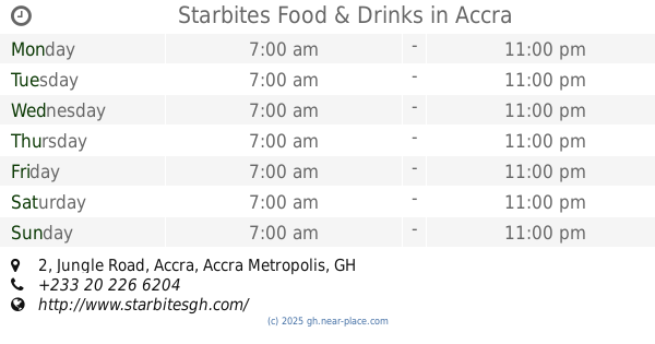
Starbites Food & Drinks
2 Jungle Road, Accra
Restaurant
read more
677 m
Mum's Kitchen
Accra
Restaurant
read more
709 m
Restaurant TP
4121, Garden road, Accra
Restaurant
read more
783 m
WAFFAKES, Waffles, Pancakes & more
Accra
Restaurant
read more
789 m
Cynthia's Night Tea & Indomie
Watermelon Avenue, Tema
Restaurant
read more
840 m
Rose Joy Restaurant
Accra
Restaurant
read more
845 m
Papaye Fast Food - Spintex
Spintex Road, Accra
Restaurant
read more
867 m
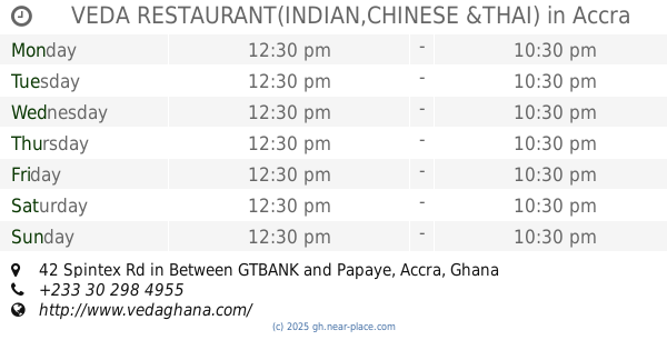
VEDA RESTAURANT(INDIAN,CHINESE &THAI)
42 Spintex Rd in Between GTBANK and Papaye
Restaurant
read more
903 m
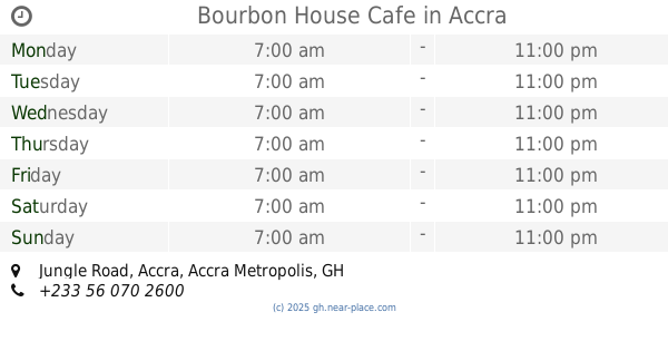
Bourbon House Cafe
Shop NoB1B, A&C Mall, Jungle Road, Accra
Restaurant
read more
919 m
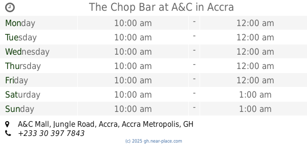
The Chop Bar at A&C
A&C Mall Jungle Road, Accra
Restaurant
read more
932 m
The Venue
Madina
Restaurant
read more
959 m
Papaye - Spintex
Accra
Restaurant
read more
974 m
Salmas Eatery
Otele Avenue, Accra
Restaurant
read more
982 m
The Calorie HotSpot at DreamTree
Adjiringanor, Madina
Restaurant
read more
985 m
The Venue
Apple Street, Accra
Restaurant
read more
986 m
Samba Food House
Otele Avenue, Accra
Restaurant
read more
1.045 km
Living Room
Flower Road, Accra
Restaurant
read more
1.104 km
East Legon khebab House
East Legon, Accra
Restaurant
read more
1.146 km
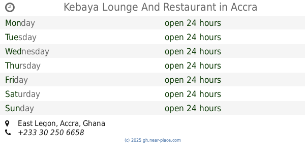
Kebaya Lounge And Restaurant
East Legon, Accra
Restaurant
read more
1.361 km
chicken and pork joint
La-Bawaleshi Road, Accra
Restaurant
read more
📑
all categories
Accounting
Administrative area level 1
Administrative area level 2
Airport
Amusement park
Aquarium
Art gallery
Atm
Bakery
Bank
Bar
Beauty salon
Bicycle store
Book store
Bus station
Cafe
Campground
Car dealer
Car rental
Car repair
Car wash
Casino
Cemetery
Church
City hall
Clothing store
Colloquial area
Convenience store
Courthouse
Dentist
Department store
Doctor
Electrician
Electronics store
Embassy
Finance
Fire station
Florist
Food
Funeral home
Furniture store
Gas station
General contractor
Grocery or supermarket
Gym
Hair care
Hardware store
Health
Hindu Temple
Home goods store
Hospital
Insurance agency
Intersection
Jewelry store
Laundry
Lawyer
Library
Liquor store
Local government office
Locality
Locksmith
Lodging
Meal delivery
Meal takeaway
Mosque
Movie rental
Movie theater
Moving company
Museum
Natural feature
Neighborhood
Night club
Painter
Park
Parking
Pet store
Pharmacy
Physiotherapist
Place of worship
Plumber
Point of interest
Police
Post office
Premise
Real estate agency
Restaurant
Roofing contractor
Route
Rv park, camping
School
Shoe store
Shopping mall
Spa
Stadium
Storage
Store
Subpremise
Subway station
Supermarket
Synagogue
Taxi stand
Train station
Transit station
Travel agency
University
Veterinary care
Zoo
sublocality level 1
↑