School nearby Johans Preparatory School
Ghana
School nearby Johans Preparatory School
Johans Preparatory School
Mpoase, Accra Ghana
contacts phone
:
+233
Latitude:
5.5301617
, Longitude:
-0.2520927
read more
nearest School
79 m
New Success Academy
Mpoase, Accra
School
read more
252 m
St. Elizabeth Sch. Complex
Ghana
School
read more
312 m
Kharis School
22 Old Dansoman High Street, Accra
School
read more
313 m
Kharis Early Development Centre
Dansoman, 205
School
read more
354 m
Calvary Wisdom Academy
Ghana
School
read more
395 m
New Universal Academy JHS, Alaji
Appiah Street, Accra
School
read more
399 m
St. Mark Preparatory School
Nii Amartey Avenue, Accra
School
read more
491 m
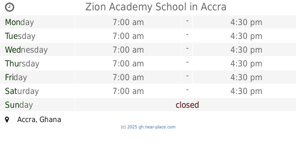
Zion Academy School
Accra
School
read more
522 m
Riches of Glory Academy
Accra
School
read more
608 m
Zion Academy
Camara Hotel, 4th Guggisberg Avenue, Accra
School
read more
647 m
Eddhley International School
Nii Kpakpo Moffat Street, Accra
School
read more
697 m
Richmat Education Center
Accra
School
read more
714 m
Chorkor Presby Primary School
Old Winneba Road, Accra
School
read more
740 m
St. Dominic Nursery School
Titus Street, Accra
School
read more
754 m
Feemepp Saviour School
Accra
School
read more
771 m
Rosda School
Kaashimi Street, Dansoman
School
read more
791 m
New Hope Of Glory Academy
Ghana
School
read more
795 m
Ewit Greenwhich Classical Academy
Accra
School
read more
819 m
Rising Star Academy
Outer Ring Road, Accra
School
read more
834 m
Top Class Education Centre
Laryea, Addo Street, Accra
School
read more
868 m
Glorious Grammar School
Ghana
School
read more
950 m
مدرسة الباكيات
Kweikuma Road, Accra
School
read more
1.104 km
Saint Marys
Chemu Road, Accra
School
read more
1.106 km
CAGD Staff Training School
Accra
School
read more
1.147 km
Duke Williams Ltd, Mamprobi Office
10 Fanaa Crescent, Accra
School
read more
📑
all categories
Accounting
Administrative area level 1
Administrative area level 2
Airport
Amusement park
Aquarium
Art gallery
Atm
Bakery
Bank
Bar
Beauty salon
Bicycle store
Book store
Bus station
Cafe
Campground
Car dealer
Car rental
Car repair
Car wash
Casino
Cemetery
Church
City hall
Clothing store
Colloquial area
Convenience store
Courthouse
Dentist
Department store
Doctor
Electrician
Electronics store
Embassy
Finance
Fire station
Florist
Food
Funeral home
Furniture store
Gas station
General contractor
Grocery or supermarket
Gym
Hair care
Hardware store
Health
Hindu Temple
Home goods store
Hospital
Insurance agency
Intersection
Jewelry store
Laundry
Lawyer
Library
Liquor store
Local government office
Locality
Locksmith
Lodging
Meal delivery
Meal takeaway
Mosque
Movie rental
Movie theater
Moving company
Museum
Natural feature
Neighborhood
Night club
Painter
Park
Parking
Pet store
Pharmacy
Physiotherapist
Place of worship
Plumber
Point of interest
Police
Post office
Premise
Real estate agency
Restaurant
Roofing contractor
Route
Rv park, camping
School
Shoe store
Shopping mall
Spa
Stadium
Storage
Store
Subpremise
Subway station
Supermarket
Synagogue
Taxi stand
Train station
Transit station
Travel agency
University
Veterinary care
Zoo
sublocality level 1
↑