School nearby Kaneshie 1 Junior High School
Ghana
School nearby Kaneshie 1 Junior High School
Kaneshie 1 Junior High School
Anunsah Clottey Street, Accra Ghana
contacts phone
:
+233
Latitude:
5.5678524
, Longitude:
-0.2337699
read more
nearest School
396 m
Accra Wesley Girls Senior High School
Nii Lantey Okunka Street, Accra
School
read more
399 m
Joulu Galaxy School
Winneba Road, Accra
School
read more
412 m
Galore International College
Accra
School
read more
426 m
Cripple's Home
Nii Asere Ayittey Road, Accra
School
read more
583 m
St. Nicholas Preparatory School
APOSTOLIC CHURCH BUBUASHIE,, Accra
School
read more
583 m
Mega Sales Acedemy
Klotey Road, Accra
School
read more
592 m
Fly High
Accra
School
read more
599 m
Kaneshie Kingsway Cluster Of Schools
Accra
School
read more
635 m
Kaneshie Presbytarian School
Shia Shia Street, Accra
School
read more
686 m
Awudome JHS
Awudome Crescent, Accra
School
read more
689 m
Kanshie Bishop1&2 JHS
Accra
School
read more
706 m
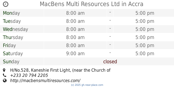
MacBens Multi Resources Ltd
H/No.528, Kaneshie First Light, (near the Church of Pentecost- Kaneshie Central)
School
read more
799 m
Corporate IT (CiTA)
CiTA Technology Campus Location: Kaneshie-Mamprobi Road, ABii National Building. Near st. Andrew Anglican Church. P.O.Box CT 9619, Ghana, Accra
School
read more
869 m
Kaneshie Shs Tech
Abosseyokai, Accra
School
read more
869 m
ELCG Main Office
Accra
School
read more
873 m
Media World
Mantse Boi Street, Accra
School
read more
919 m
Emit Electronic Institute
Theodosia Kubi St, Mateheko, Accra
School
read more
965 m
Holy Family Kindergarten
Mataheko, Accra
School
read more
969 m
Mataheko Roman Catholic Primary School
Nmenmete Walk, Accra
School
read more
971 m
Royal Beginners Nursery
Otinkorang Street, Accra
School
read more
982 m
Abossey Okai Roman Catholic Primary School
Nmenmete Walk, Accra
School
read more
1.007 km
Saint Pierre Claver
Abosseyokai, Accra
School
read more
1.012 km
Mataheko Roman Catholic JHS
Jonkobri Road, Accra
School
read more
1.107 km
Lospat School Complex
Abosseyokai, Accra
School
read more
1.13 km
Starward Preparatory School
Flo Oyeo Road, Accra
School
read more
📑
all categories
Accounting
Administrative area level 1
Administrative area level 2
Airport
Amusement park
Aquarium
Art gallery
Atm
Bakery
Bank
Bar
Beauty salon
Bicycle store
Book store
Bus station
Cafe
Campground
Car dealer
Car rental
Car repair
Car wash
Casino
Cemetery
Church
City hall
Clothing store
Colloquial area
Convenience store
Courthouse
Dentist
Department store
Doctor
Electrician
Electronics store
Embassy
Finance
Fire station
Florist
Food
Funeral home
Furniture store
Gas station
General contractor
Grocery or supermarket
Gym
Hair care
Hardware store
Health
Hindu Temple
Home goods store
Hospital
Insurance agency
Intersection
Jewelry store
Laundry
Lawyer
Library
Liquor store
Local government office
Locality
Locksmith
Lodging
Meal delivery
Meal takeaway
Mosque
Movie rental
Movie theater
Moving company
Museum
Natural feature
Neighborhood
Night club
Painter
Park
Parking
Pet store
Pharmacy
Physiotherapist
Place of worship
Plumber
Point of interest
Police
Post office
Premise
Real estate agency
Restaurant
Roofing contractor
Route
Rv park, camping
School
Shoe store
Shopping mall
Spa
Stadium
Storage
Store
Subpremise
Subway station
Supermarket
Synagogue
Taxi stand
Train station
Transit station
Travel agency
University
Veterinary care
Zoo
sublocality level 1
↑