School nearby My Playroom School
Ghana
School nearby My Playroom School
My Playroom School
Tesano, Accra Ghana
contacts phone
:
+233
Latitude:
5.5991941
, Longitude:
-0.2264836
read more
nearest School
278 m
GLABAP Pre-school
Tesano, Accra
School
read more
348 m
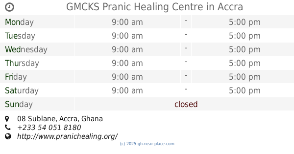
GMCKS Pranic Healing Centre
Tesano, 08 Sublane, Accra
School
read more
449 m
GTUC Software Systems Unit
North Industrial Area, Accra
School
read more
457 m
GTUC Reception Tessano
Nsawam Road, Accra
School
read more
483 m
Library
GTUC-SRC Office, Accra
School
read more
512 m
Rev. William Vernon Ofori Memorial School
Accra
School
read more
627 m
Danquah International school
Abeka, Accra
School
read more
730 m
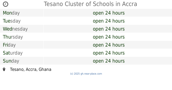
Tesano Cluster of Schools
Tesano, Accra
School
read more
826 m
English Language Laboratory
Alajo, Accra
School
read more
841 m
E-Language Laboratory
Alajo, Accra
School
read more
943 m
Mizpah International School
Ninth Road, Accra
School
read more
944 m
Fun And Learn (North Kaneshi.)
1st Mukose link, Accra
School
read more
951 m
God's Grace International Montessori School
P. O. Box AB 56 Abeka, 2 Naa Ata Street, Accra
School
read more
952 m
Kwame
2 Naa Ata Street, Accra
School
read more
955 m
Sam's Academy
Accra
School
read more
968 m
Tina Roses Creche and Day Care
16th Close, Accra
School
read more
995 m
Alajo Public School
Alajo, Accra
School
read more
1.019 km
Green U College
2 Naa Ata Street, Accra
School
read more
1.031 km
Success Creche Nursery & Kindergarten
Abeka, Accra
School
read more
1.047 km
Joyful Home Academy
Pinto Road, Accra
School
read more
1.048 km
CELPS Ghana
Accra
School
read more
1.056 km
Ghana Technology University College C15
Nsawam Road, Accra
School
read more
1.141 km
ALABASTER INTERNATIONAL SCHOOL
4th Mukose link, Accra
School
read more
1.262 km
Mothers' Pride, North kaneshie
Abeka, Accra
School
read more
1.399 km
Holy Bethel Preparatory School
2nd Manhean Loop, Accra
School
read more
📑
all categories
Accounting
Administrative area level 1
Administrative area level 2
Airport
Amusement park
Aquarium
Art gallery
Atm
Bakery
Bank
Bar
Beauty salon
Bicycle store
Book store
Bus station
Cafe
Campground
Car dealer
Car rental
Car repair
Car wash
Casino
Cemetery
Church
City hall
Clothing store
Colloquial area
Convenience store
Courthouse
Dentist
Department store
Doctor
Electrician
Electronics store
Embassy
Finance
Fire station
Florist
Food
Funeral home
Furniture store
Gas station
General contractor
Grocery or supermarket
Gym
Hair care
Hardware store
Health
Hindu Temple
Home goods store
Hospital
Insurance agency
Intersection
Jewelry store
Laundry
Lawyer
Library
Liquor store
Local government office
Locality
Locksmith
Lodging
Meal delivery
Meal takeaway
Mosque
Movie rental
Movie theater
Moving company
Museum
Natural feature
Neighborhood
Night club
Painter
Park
Parking
Pet store
Pharmacy
Physiotherapist
Place of worship
Plumber
Point of interest
Police
Post office
Premise
Real estate agency
Restaurant
Roofing contractor
Route
Rv park, camping
School
Shoe store
Shopping mall
Spa
Stadium
Storage
Store
Subpremise
Subway station
Supermarket
Synagogue
Taxi stand
Train station
Transit station
Travel agency
University
Veterinary care
Zoo
sublocality level 1
↑