School nearby Paradise Children Academy
Ghana
School nearby Paradise Children Academy
Paradise Children Academy
Parakuo Estates, Accra, Ghana
contacts phone
:
+233
Latitude:
5.6425551
, Longitude:
-0.2234931
larger map & directions
read more
nearest School
Paradise Children Academy
Dome Road Parakuo Estate
School
read more
14 m
Paradise Children Academy
Acra
School
read more
14 m
Paradise Children Academy
Accra
School
read more
117 m
Midodzi James Mawuko
Dome Road, Accra
School
read more
129 m
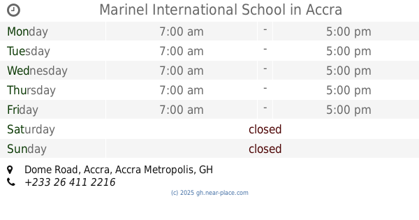
Marinel International School
Dome Road, Accra
School
read more
170 m
Learning Adventure Montessori School
Parakuo Estates, Accra
School
read more
241 m
Dominion Miracle Church
Dome crossing , Achimota, Accra
School
read more
466 m
Udanok Academy
Paradise Residential Area, Accra
School
read more
475 m
Greater Tomorrow
Accra
School
read more
573 m
Beautiful Morning Glory International School
Dome Road, Accra
School
read more
629 m
St. James Prep. School
Accra
School
read more
673 m
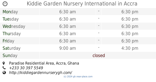
Kiddie Garden Nursery International
Paradise Residential Area, Accra
School
read more
688 m
Rising Sun Montessori Sch, Dome
Accra
School
read more
713 m
New Legon Oko Presby School
Parakuo Estates, Accra
School
read more
748 m
Deacons Academy Montessori
Accra
School
read more
776 m
Gem Driving School
West Legon, Accra
School
read more
973 m
Gate Management Consult
Asafo Agyei Street, Accra
School
read more
1.003 km
Mount Zion Academy Complex
Accra
School
read more
1.034 km
Freshers Complex School
Acra
School
read more
1.034 km
Freshers Complex School
Accra
School
read more
1.457 km
New Fountain Int.
Acra
School
read more
1.6 km
Tema Sec Sch
Saint Johns - Dome - Kwabenya - Brekusu Road, Accra
School
read more
1.733 km
Perfect School
Accra
School
read more
1.984 km
Jorinda Cake Training School
Accra
School
read more
2.226 km
Grins N Giggles
105 Nii Annan Street, Accra
School
read more
📑
all categories
Accounting
Administrative area level 1
Administrative area level 2
Airport
Amusement park
Aquarium
Art gallery
Atm
Bakery
Bank
Bar
Beauty salon
Bicycle store
Book store
Bus station
Cafe
Campground
Car dealer
Car rental
Car repair
Car wash
Casino
Cemetery
Church
City hall
Clothing store
Colloquial area
Convenience store
Courthouse
Dentist
Department store
Doctor
Electrician
Electronics store
Embassy
Finance
Fire station
Florist
Food
Funeral home
Furniture store
Gas station
General contractor
Grocery or supermarket
Gym
Hair care
Hardware store
Health
Hindu Temple
Home goods store
Hospital
Insurance agency
Intersection
Jewelry store
Laundry
Lawyer
Library
Liquor store
Local government office
Locality
Locksmith
Lodging
Meal delivery
Meal takeaway
Mosque
Movie rental
Movie theater
Moving company
Museum
Natural feature
Neighborhood
Night club
Painter
Park
Parking
Pet store
Pharmacy
Physiotherapist
Place of worship
Plumber
Point of interest
Police
Post office
Premise
Real estate agency
Restaurant
Roofing contractor
Route
Rv park, camping
School
Shoe store
Shopping mall
Spa
Stadium
Storage
Store
Subpremise
Subway station
Supermarket
Synagogue
Taxi stand
Train station
Transit station
Travel agency
University
Veterinary care
Zoo
sublocality level 1
↑