School nearby PHILEO CRECHE AND DAYCARE
Ghana
School nearby PHILEO CRECHE AND DAYCARE
PHILEO CRECHE AND DAYCARE
Ashongman Estates, Ghana
contacts phone
:
+233
Latitude:
5.70364
, Longitude:
-0.23914
larger map & directions
read more
nearest School
436 m
Child Of The Light School
Ashongman Estates kwabenya Aboum Junction, ALine, Ashongman Estates
School
read more
471 m
Capital Hill Int. School
Ghana
School
read more
482 m
Child Of The Light School
Ashongman Estates
School
read more
483 m
Child of the Light School
Kwabenya-Berekuso-Aburi Road
School
read more
484 m
Atomic Hills Presbyterian School
Ghana
School
read more
539 m
Atomic Hills Estate Demonstration School
Ghana
School
read more
737 m
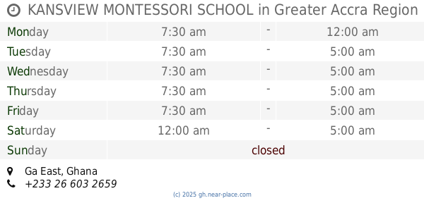
KANSVIEW MONTESSORI SCHOOL
School
read more
737 m
Saint James Anglican School
School
read more
762 m
Keskim I.T Training Centre
School
read more
774 m
Hillview Momtessori School
Ghana
School
read more
810 m
St Mark Primary and JSS
Ghana
School
read more
882 m
Republic Model School
School
read more
1.077 km
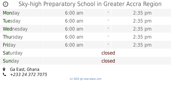
Sky-high Preparatory School
School
read more
1.271 km
Daylight International School
Kwabenya
School
read more
1.568 km
North Star Academy School
Ghana
School
read more
1.64 km
Lormva Flats
Atomic Hills Estate Street, Kwabenya
School
read more
1.644 km
Michelle Montessori
Ashongman Ridge
School
read more
1.788 km
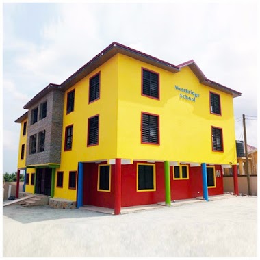
WestBridge School
School
read more
1.95 km
Sambel Academy
Kwabenya
School
read more
1.985 km
Kwabenya MA Basic Schools
Kwabenya
School
read more
1.999 km
Kwabenya Cluster Of Schools
Kwabenya
School
read more
2.056 km
Wards International School. Kwabenya
Kwabenya
School
read more
2.336 km
G-best Excellence Academy (New Ashongman.)
School
read more
2.34 km
VicGrace International Montessori
Kwabenya
School
read more
2.646 km
Fair Light International Academy
Kwabenya
School
read more
📑
all categories
Accounting
Administrative area level 1
Administrative area level 2
Airport
Amusement park
Aquarium
Art gallery
Atm
Bakery
Bank
Bar
Beauty salon
Bicycle store
Book store
Bus station
Cafe
Campground
Car dealer
Car rental
Car repair
Car wash
Casino
Cemetery
Church
City hall
Clothing store
Colloquial area
Convenience store
Courthouse
Dentist
Department store
Doctor
Electrician
Electronics store
Embassy
Finance
Fire station
Florist
Food
Funeral home
Furniture store
Gas station
General contractor
Grocery or supermarket
Gym
Hair care
Hardware store
Health
Hindu Temple
Home goods store
Hospital
Insurance agency
Intersection
Jewelry store
Laundry
Lawyer
Library
Liquor store
Local government office
Locality
Locksmith
Lodging
Meal delivery
Meal takeaway
Mosque
Movie rental
Movie theater
Moving company
Museum
Natural feature
Neighborhood
Night club
Painter
Park
Parking
Pet store
Pharmacy
Physiotherapist
Place of worship
Plumber
Point of interest
Police
Post office
Premise
Real estate agency
Restaurant
Roofing contractor
Route
Rv park, camping
School
Shoe store
Shopping mall
Spa
Stadium
Storage
Store
Subpremise
Subway station
Supermarket
Synagogue
Taxi stand
Train station
Transit station
Travel agency
University
Veterinary care
Zoo
sublocality level 1
↑