School nearby White Dove School Complex
Ghana
School nearby White Dove School Complex
White Dove School Complex
Taifa Ghana
contacts phone
:
+233
Latitude:
5.6647043
, Longitude:
-0.2567838
read more
nearest School
360 m
The Royal Beacon School
Taifa
School
read more
509 m
Higher Learning Int. School
Taifa
School
read more
594 m
Sensels School
Taifa
School
read more
714 m
Shalom International School
Taifa
School
read more
755 m
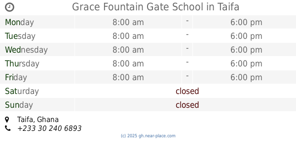
Grace Fountain Gate School
Taifa
School
read more
932 m
St.Ncholas Computer Based School Academy
Taifa Burkina-R O Junction
School
read more
940 m
Higher Learning Int.school
Taifa Banyase
School
read more
964 m
Golden Star Prep School
ofankor
School
read more
964 m
Ofankor St. Peter's Anglican School
Taifa
School
read more
964 m
Silicon Valley International School
Ofankor
School
read more
964 m
Sarfoa Memorial School
sarfoa memorial school
School
read more
977 m
EAGLENEST INTERNATIONAL SCHOOL
Taifa
School
read more
991 m
Ghanaian Child School
Ofankor
School
read more
993 m
Taifa Burkina Central Mosque
Kwabenya
School
read more
1.001 km
taifa community school
Taifa
School
read more
1.018 km
Salvation Preparatory And Junior High School
Kwabenya
School
read more
1.047 km
FAITH KIDS ACADEMY
Taifa
School
read more
1.063 km
Mount Mary Schools
Taifa
School
read more
1.114 km
Great Favour International School
Kwabenya
School
read more
1.126 km
Anglican School Ofankor
Taifa
School
read more
1.281 km
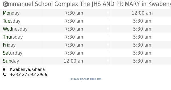
Emmanuel School Complex The JHS AND PRIMARY
Kwabenya
School
read more
1.829 km
Jancel Christian School
Ga West
School
read more
1.982 km
Bright Lilies Early Child Learning Center
Saint Johns - Dome - Kwabenya - Brekusu Road, Taifa
School
read more
2.284 km
West Hatch School
Kwabenya
School
read more
2.33 km
Blessed Home Sch And Crech
Kwabenya
School
read more
📑
all categories
Accounting
Administrative area level 1
Administrative area level 2
Airport
Amusement park
Aquarium
Art gallery
Atm
Bakery
Bank
Bar
Beauty salon
Bicycle store
Book store
Bus station
Cafe
Campground
Car dealer
Car rental
Car repair
Car wash
Casino
Cemetery
Church
City hall
Clothing store
Colloquial area
Convenience store
Courthouse
Dentist
Department store
Doctor
Electrician
Electronics store
Embassy
Finance
Fire station
Florist
Food
Funeral home
Furniture store
Gas station
General contractor
Grocery or supermarket
Gym
Hair care
Hardware store
Health
Hindu Temple
Home goods store
Hospital
Insurance agency
Intersection
Jewelry store
Laundry
Lawyer
Library
Liquor store
Local government office
Locality
Locksmith
Lodging
Meal delivery
Meal takeaway
Mosque
Movie rental
Movie theater
Moving company
Museum
Natural feature
Neighborhood
Night club
Painter
Park
Parking
Pet store
Pharmacy
Physiotherapist
Place of worship
Plumber
Point of interest
Police
Post office
Premise
Real estate agency
Restaurant
Roofing contractor
Route
Rv park, camping
School
Shoe store
Shopping mall
Spa
Stadium
Storage
Store
Subpremise
Subway station
Supermarket
Synagogue
Taxi stand
Train station
Transit station
Travel agency
University
Veterinary care
Zoo
sublocality level 1
↑