Bakery nearby Joyful deli &desserts
Ghana
Bakery nearby Joyful deli &desserts
Joyful deli &desserts
Mama Adjele Road, Accra, Accra Metropolis, GH Ghana
contacts phone
:
+233 26 624 0348
website:
joyfulcakesgh.business.site
Latitude:
5.620541
, Longitude:
-0.152502
larger map & directions
read more
nearest Bakery
590 m
Oriental Patisserie
Accra
Bakery
read more
1.569 km
Pink panda bakery
Spintex Road, Accra
Bakery
read more
2.051 km
Baked Gh
Dr Tagoe St, Accra
Bakery
read more
2.471 km
Baker Girl Ghana Limited
Agblezaa - Manet Road, Accra
Bakery
read more
2.49 km
Teapal Bakery & Mini Mart
Abotsi Street, Accra
Bakery
read more
2.64 km
MaxMart Bakery
Aluguntugui Street, Accra
Bakery
read more
2.691 km
Foonoo Phood Factory
Accra
Bakery
read more
2.951 km
Cake Oooo
Agblaashie Link, Accra
Bakery
read more
3.031 km
Bofrot GH
Pineapple Loop, Legon
Bakery
read more
3.066 km
The Butter place bakery
Accra
Bakery
read more
3.274 km
D café
Marina Mall, Airport Bypass Road, Accra
Bakery
read more
3.281 km
Jaesm Cakes
Accra
Bakery
read more
3.329 km
Cuppycake House
La-Bawaleshi Road, Accra
Bakery
read more
3.436 km
DyazBakeshop
Nii Osae Ntiful Avenue
Bakery
read more
3.532 km
Kakes N Bakes
Accra
Bakery
read more
3.625 km
Stesi Ghana House
Accra
Bakery
read more
3.777 km
Tysons Bagel Bakery
Accra
Bakery
read more
4.247 km
La Baguette
Ocansey Plaza
Bakery
read more
4.273 km
Pink Panda Bakery
348 fourth street, east legon, Accra
Bakery
read more
4.616 km
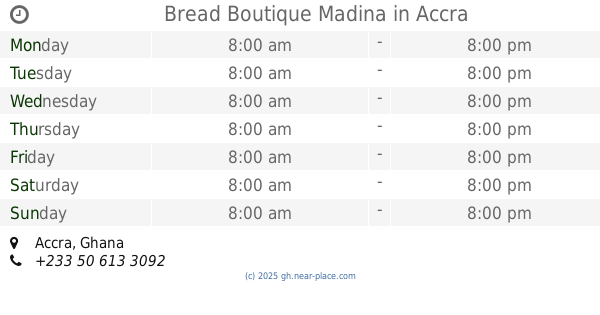
Bread Boutique Madina
Accra
Bakery
read more
4.749 km
EAT by ZÖE
2 Mankralo Street, East Cantonments, Accra
Bakery
read more
4.828 km
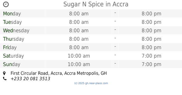
Sugar N Spice
First Circular Road, Accra
Bakery
read more
5.862 km
Kanda Bakery
Ayawaso East Sub Metro, Accra
Bakery
read more
5.889 km
Vixx Cakes
Ayawaso East Sub Metro, Accra
Bakery
read more
6.867 km
Afro Pizza Inn And Bakery Ltd
Teshie, Accra
Bakery
read more
📑
all categories
Accounting
Administrative area level 1
Administrative area level 2
Airport
Amusement park
Aquarium
Art gallery
Atm
Bakery
Bank
Bar
Beauty salon
Bicycle store
Book store
Bus station
Cafe
Campground
Car dealer
Car rental
Car repair
Car wash
Casino
Cemetery
Church
City hall
Clothing store
Colloquial area
Convenience store
Courthouse
Dentist
Department store
Doctor
Electrician
Electronics store
Embassy
Finance
Fire station
Florist
Food
Funeral home
Furniture store
Gas station
General contractor
Grocery or supermarket
Gym
Hair care
Hardware store
Health
Hindu Temple
Home goods store
Hospital
Insurance agency
Intersection
Jewelry store
Laundry
Lawyer
Library
Liquor store
Local government office
Locality
Locksmith
Lodging
Meal delivery
Meal takeaway
Mosque
Movie rental
Movie theater
Moving company
Museum
Natural feature
Neighborhood
Night club
Painter
Park
Parking
Pet store
Pharmacy
Physiotherapist
Place of worship
Plumber
Point of interest
Police
Post office
Premise
Real estate agency
Restaurant
Roofing contractor
Route
Rv park, camping
School
Shoe store
Shopping mall
Spa
Stadium
Storage
Store
Subpremise
Subway station
Supermarket
Synagogue
Taxi stand
Train station
Transit station
Travel agency
University
Veterinary care
Zoo
sublocality level 1
↑