Bar nearby Sweeties
Coronavirus disease (COVID-19) Situation
confirmed cases
171889
deaths
1462
Ghana
Bar nearby Sweeties
Sweeties
Mama Adjele Road, Accra Ghana
contacts phone
:
+233
Latitude:
5.6203955
, Longitude:
-0.1529289
read more
nearest Bar
724 m
Joe's Bar In Oak Plaza Hotel
Accra
Bar
read more
1.613 km
Sandy Spot
Spintex Road, Accra
Bar
read more
1.756 km
Day Break( Taco Taco)
East Legon, Accra
Bar
read more
1.833 km
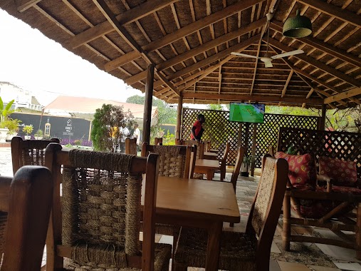
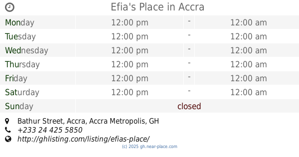
Efia's Place
Bathur Street, Accra
Bar
read more
2.052 km
Briefcase Pub & Shisha
Flower Road, Accra
Bar
read more
2.056 km
Diamond's Pub & Grill
Sharp Curve, Boundary Road, Accra
Bar
read more
2.155 km
Adehye House - Irish Pub
1, Bathur Street, Accra
Bar
read more
2.224 km
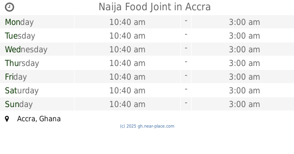
Naija Food Joint
Accra
Bar
read more
2.428 km
Yenkodi Bar & Restaurant
Corner of Mensah Wood Road & Opposite Ghana Link Services, Lagos Avenue, Accra
Bar
read more
2.433 km
The Honeysuckle - A&C Mall Branch
Accra
Bar
read more
2.457 km
K Power Pub
Garden Road, Accra
Bar
read more
2.504 km
Figures Pub
Bissau Avenue, Accra
Bar
read more
2.521 km
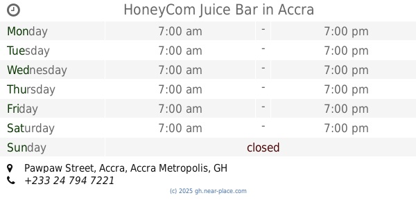
HoneyCom Juice Bar
Pawpaw Street, Accra
Bar
read more
2.582 km
Abotare Spot
air force market
Bar
read more
2.585 km
Ashquams Pub
Boundary Road, Accra
Bar
read more
2.666 km
Bar Naas
Accra
Bar
read more
2.716 km
AM&PM
Accra
Bar
read more
2.743 km
Chez Amis
Shitor Street., Accra
Bar
read more
2.753 km
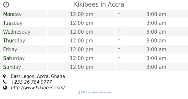
Kikibees
East Legon, Accra
Bar
read more
3.099 km
Brotherhood Pub
Madina
Bar
read more
3.267 km
Bamboo Spot
Accra
Bar
read more
3.462 km
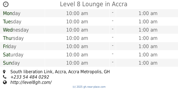
Level 8 Lounge
One, South liberation Link, Accra
Bar
read more
3.469 km
ibis Styles Accra Airport City Hotel
Plot 24 area Airport City Enclave, Accra
Bar
read more
3.481 km
ibis Styles Accra Airport City Hotel
area Airport City Enclave, Plot 24 Liberation Road, Accra
Bar
read more
3.556 km
The Godfather Bar & Grill
Unnamed Road, Accra
Bar
read more
📑
all categories
Accounting
Administrative area level 1
Administrative area level 2
Airport
Amusement park
Aquarium
Art gallery
Atm
Bakery
Bank
Bar
Beauty salon
Bicycle store
Book store
Bus station
Cafe
Campground
Car dealer
Car rental
Car repair
Car wash
Casino
Cemetery
Church
City hall
Clothing store
Colloquial area
Convenience store
Courthouse
Dentist
Department store
Doctor
Electrician
Electronics store
Embassy
Finance
Fire station
Florist
Food
Funeral home
Furniture store
Gas station
General contractor
Grocery or supermarket
Gym
Hair care
Hardware store
Health
Hindu Temple
Home goods store
Hospital
Insurance agency
Intersection
Jewelry store
Laundry
Lawyer
Library
Liquor store
Local government office
Locality
Locksmith
Lodging
Meal delivery
Meal takeaway
Mosque
Movie rental
Movie theater
Moving company
Museum
Natural feature
Neighborhood
Night club
Painter
Park
Parking
Pet store
Pharmacy
Physiotherapist
Place of worship
Plumber
Point of interest
Police
Post office
Premise
Real estate agency
Restaurant
Roofing contractor
Route
Rv park, camping
School
Shoe store
Shopping mall
Spa
Stadium
Storage
Store
Subpremise
Subway station
Supermarket
Synagogue
Taxi stand
Train station
Transit station
Travel agency
University
Veterinary care
Zoo
sublocality level 1
↑