Cafe nearby Vegan Spice Bakery
Ghana
Cafe nearby Vegan Spice Bakery
Vegan Spice Bakery
Osu, 10 Puplampu Road, Accra Ghana
contacts phone
:
+233
Latitude:
5.55859
, Longitude:
-0.1763355
read more
nearest Cafe
365 m
The YieldJuicery
Klannaa Street, Accra
Cafe
read more
451 m
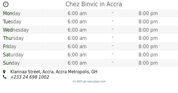
Chez Binvic
Klannaa Street, Accra
Cafe
read more
542 m
Kukun
10 Koi Street, Accra
Cafe
read more
642 m
NourishLab Smoothy's
Accra
Cafe
read more
673 m
Frankie's Foods And Rooms LTD
Oxford st Road , Cantonments, Accra
Cafe
read more
823 m
Sotto Zerro Gelateria
North Ridge, Accra
Cafe
read more
823 m
Sotto Zerro
North Ridge, Accra
Cafe
read more
872 m
Second Cup Osu
Ghana
Cafe
read more
897 m
Andis Barber's Shop
Labone, Accra
Cafe
read more
1.149 km
Vida e Caffe - Labone
Labone, Accra
Cafe
read more
1.305 km
Slices Cafe
F832/1 First Street, OSU, Re, Accra
Cafe
read more
1.321 km
Brown Shugar Bakery
Osu, Accra
Cafe
read more
1.514 km
The Cupcake Boutique
Accra
Cafe
read more
1.519 km
Ringway Estates
8th Ringway, Accra
Cafe
read more
1.573 km
UB Café - Ringway
Ringway Link, Accra
Cafe
read more
1.589 km
Cafe Mondo
Cantonments, Accra
Cafe
read more
1.798 km
La Beat Business Centre
55, Olooti Road, Accra
Cafe
read more
2.246 km
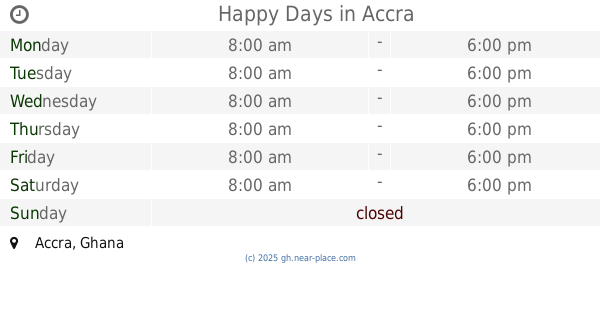
Happy Days
Accra
Cafe
read more
2.492 km
Ict Plus Ltd
Kojo sardine
Cafe
read more
2.772 km
Vida e Caffe - Accra Financial Centre
Financial Centre, Independence Avenue, Accra
Cafe
read more
2.934 km
The Deli
Mövenpick Ambassador Hotel, Independence Avenue, Accra
Cafe
read more
3.044 km
Multilynk Business Center
Labadi, Accra
Cafe
read more
3.057 km
LADL Patisserie
23 Latebu Crescent, East Cantonments Estates, Accra
Cafe
read more
4.402 km
Kanta Bar
South Industrial Area, Accra
Cafe
read more
5.108 km
Cash Money Barbering
Burma Camp, Accra
Cafe
read more
📑
all categories
Accounting
Administrative area level 1
Administrative area level 2
Airport
Amusement park
Aquarium
Art gallery
Atm
Bakery
Bank
Bar
Beauty salon
Bicycle store
Book store
Bus station
Cafe
Campground
Car dealer
Car rental
Car repair
Car wash
Casino
Cemetery
Church
City hall
Clothing store
Colloquial area
Convenience store
Courthouse
Dentist
Department store
Doctor
Electrician
Electronics store
Embassy
Finance
Fire station
Florist
Food
Funeral home
Furniture store
Gas station
General contractor
Grocery or supermarket
Gym
Hair care
Hardware store
Health
Hindu Temple
Home goods store
Hospital
Insurance agency
Intersection
Jewelry store
Laundry
Lawyer
Library
Liquor store
Local government office
Locality
Locksmith
Lodging
Meal delivery
Meal takeaway
Mosque
Movie rental
Movie theater
Moving company
Museum
Natural feature
Neighborhood
Night club
Painter
Park
Parking
Pet store
Pharmacy
Physiotherapist
Place of worship
Plumber
Point of interest
Police
Post office
Premise
Real estate agency
Restaurant
Roofing contractor
Route
Rv park, camping
School
Shoe store
Shopping mall
Spa
Stadium
Storage
Store
Subpremise
Subway station
Supermarket
Synagogue
Taxi stand
Train station
Transit station
Travel agency
University
Veterinary care
Zoo
sublocality level 1
↑