Church nearby Believers Sanctuary International
Ghana
Church nearby Believers Sanctuary International
Believers Sanctuary International
Ghana Ghana
contacts phone
:
+233
Latitude:
5.6870744
, Longitude:
-0.1733941
read more
nearest Church
32 m
Upcity Church International
Ghana
Church
read more
110 m
The Miracle Family Church
Ghana
Church
read more
194 m
Powerful Finger Of Min. Intl.
Redco
Church
read more
250 m
Upcity Church International
Redco
Church
read more
403 m
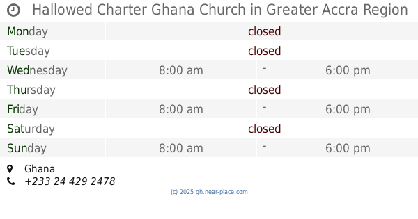
Hallowed Charter Ghana Church
Ghana
Church
read more
407 m
World Missionary Church International
Ghana
Church
read more
418 m
Victory Bible Church, REDCO
Ghana
Church
read more
544 m
Assemblies of God
Adenta West
Church
read more
609 m
Apostles Revelation Society
Adenta West
Church
read more
629 m
kingdom hall of Jehovah's witnesses, Madina Market
Madina
Church
read more
668 m
Kingdom Of Grace Chapel
Redco
Church
read more
773 m
The Church of Jesus Christ of Latter-Day Saints, Adenta
Ghana
Church
read more
777 m
Presbyterian Church Of Ghana - Adentan Christ Congregation
Madina
Church
read more
856 m
Reconciliation Church International
N4, Madina
Church
read more
928 m
Lighthouse Chapel International, La-Nkwantanang Branch
Behind Redco Flats,, Madina
Church
read more
963 m
Logos Rhema Adenta Community Assembly
Ghana
Church
read more
976 m
Harvest Chapel International,Adenta
Unnamed Road, Madina
Church
read more
987 m
Presbyterian Church Of Ghana - Convenant Congregation
Djorshie Street
Church
read more
993 m
Presbyterian church(prince of peace)
zongo junction
Church
read more
1.007 km
Covenant Presby Church
Djorshie Street
Church
read more
1.047 km
Bethel Methodist Church
Church
read more
1.118 km
Savior PRESBY CHURCH
Madina Zongo, Madina
Church
read more
1.175 km
Saviour Presby Church - Madina West
West Lybia Quarters Road, Madina
Church
read more
1.209 km
Our Lady of Assumption Catholic Church
Madina Zongo, Madina
Church
read more
1.218 km
Our Lady Of Apostles Catholic Church, Madina
Libya Quarters West, Madina
Church
read more
📑
all categories
Accounting
Administrative area level 1
Administrative area level 2
Airport
Amusement park
Aquarium
Art gallery
Atm
Bakery
Bank
Bar
Beauty salon
Bicycle store
Book store
Bus station
Cafe
Campground
Car dealer
Car rental
Car repair
Car wash
Casino
Cemetery
Church
City hall
Clothing store
Colloquial area
Convenience store
Courthouse
Dentist
Department store
Doctor
Electrician
Electronics store
Embassy
Finance
Fire station
Florist
Food
Funeral home
Furniture store
Gas station
General contractor
Grocery or supermarket
Gym
Hair care
Hardware store
Health
Hindu Temple
Home goods store
Hospital
Insurance agency
Intersection
Jewelry store
Laundry
Lawyer
Library
Liquor store
Local government office
Locality
Locksmith
Lodging
Meal delivery
Meal takeaway
Mosque
Movie rental
Movie theater
Moving company
Museum
Natural feature
Neighborhood
Night club
Painter
Park
Parking
Pet store
Pharmacy
Physiotherapist
Place of worship
Plumber
Point of interest
Police
Post office
Premise
Real estate agency
Restaurant
Roofing contractor
Route
Rv park, camping
School
Shoe store
Shopping mall
Spa
Stadium
Storage
Store
Subpremise
Subway station
Supermarket
Synagogue
Taxi stand
Train station
Transit station
Travel agency
University
Veterinary care
Zoo
sublocality level 1
↑