Clothing store nearby BenJude Boutique
Ghana
Clothing store nearby BenJude Boutique
BenJude Boutique
Cantonments, Accra Ghana
contacts phone
:
+233
Latitude:
5.58561
, Longitude:
-0.1754417
read more
nearest Clothing store
45 m
Pssuits Men Clothing
Cantonment post office, light
Clothing store
read more
524 m
Euphoric Connections
Labardi, 9 Giffard Road, Accra
Clothing store
read more
926 m
Jozel garments
Cape Coast,Ancem,New Site Liberation Crescent, Accra
Clothing store
read more
952 m
HgN-Limited
Cantonments, Fourth Circular Road, Accra
Clothing store
read more
1.033 km
Weaverbird Trading Enterprise
Dade Street, Accra
Clothing store
read more
1.13 km
Beedagel Boutique
17th Lane, Accra
Clothing store
read more
1.21 km
Noble fashion Plus
Sixth Circular Road, Accra
Clothing store
read more
1.639 km
Charlotte Prive
Accra
Clothing store
read more
1.689 km
Moda's Fashion
Tumu Avenue, Accra
Clothing store
read more
1.738 km
Boulevard Menswear
Fifth Circular Road, Accra
Clothing store
read more
1.805 km
Enams Collections
Hilla Limann Highway, Accra
Clothing store
read more
1.818 km
MG Perfectdeco
Fifth Circular Road, Accra
Clothing store
read more
1.827 km
Primatex-xl
21 Ndabaningi Sithole Road, Accra
Clothing store
read more
1.936 km
A & G Enterprise
Nima, Accra
Clothing store
read more
1.971 km
Prince Collections
Labone
Clothing store
read more
1.995 km
Hadas Clothing
Labadi Link, Accra
Clothing store
read more
2 km
Traveline Ghana
No 5, Airport City - KIA, Accra
Clothing store
read more
2.142 km
Blue Haven Boutique
Accra
Clothing store
read more
2.184 km
Wrangler Ghana
E960 13th Lane, Accra
Clothing store
read more
2.22 km
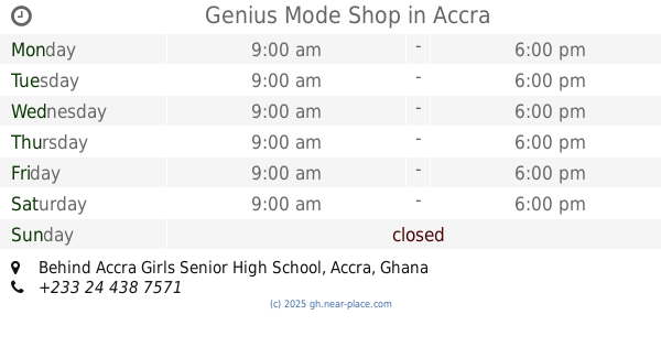
Genius Mode Shop
Behind Accra Girls Senior High School, Accra
Clothing store
read more
2.259 km
Ruby's Place
Accra
Clothing store
read more
2.388 km
CEELEX COLLECTION
GA-106-0772
Clothing store
read more
2.425 km
Exmac Fabrics
10th Street, Accra
Clothing store
read more
2.944 km
POQUA POQU
Osu, Accra
Clothing store
read more
2.984 km
Sesi Clothing
Accra
Clothing store
read more
📑
all categories
Accounting
Administrative area level 1
Administrative area level 2
Airport
Amusement park
Aquarium
Art gallery
Atm
Bakery
Bank
Bar
Beauty salon
Bicycle store
Book store
Bus station
Cafe
Campground
Car dealer
Car rental
Car repair
Car wash
Casino
Cemetery
Church
City hall
Clothing store
Colloquial area
Convenience store
Courthouse
Dentist
Department store
Doctor
Electrician
Electronics store
Embassy
Finance
Fire station
Florist
Food
Funeral home
Furniture store
Gas station
General contractor
Grocery or supermarket
Gym
Hair care
Hardware store
Health
Hindu Temple
Home goods store
Hospital
Insurance agency
Intersection
Jewelry store
Laundry
Lawyer
Library
Liquor store
Local government office
Locality
Locksmith
Lodging
Meal delivery
Meal takeaway
Mosque
Movie rental
Movie theater
Moving company
Museum
Natural feature
Neighborhood
Night club
Painter
Park
Parking
Pet store
Pharmacy
Physiotherapist
Place of worship
Plumber
Point of interest
Police
Post office
Premise
Real estate agency
Restaurant
Roofing contractor
Route
Rv park, camping
School
Shoe store
Shopping mall
Spa
Stadium
Storage
Store
Subpremise
Subway station
Supermarket
Synagogue
Taxi stand
Train station
Transit station
Travel agency
University
Veterinary care
Zoo
sublocality level 1
↑