Clothing store nearby Doss Intex Fashion
Ghana
Clothing store nearby Doss Intex Fashion
Doss Intex Fashion
Unnamed Rd,, Accra, Ghana
contacts phone
:
+233
Latitude:
5.6160342
, Longitude:
-0.236253
larger map & directions
read more
nearest Clothing store
85 m
All Goes Ghana
Akweteyman
Clothing store
read more
327 m
Selly's Hats
No. 18, Royal Street, Achimota, Akweteyman
Clothing store
read more
452 m
Jukel & Sons Ltd
Box No. 41, Mile 7, Achimota
Clothing store
read more
493 m
Bestys Collection
Achimota, Akweteyman
Clothing store
read more
528 m
Serwaa Closet
Akweteyman
Clothing store
read more
723 m
Uni Jay Collection
New Achimota, Banana Street
Clothing store
read more
759 m
Tales of Scissors
Nsawam Road, Accra
Clothing store
read more
785 m
Tippsol Showroom
Accra
Clothing store
read more
832 m
Regula Collections
Ghana
Clothing store
read more
847 m
Zuiki MODA Boutique
Akweteyman
Clothing store
read more
1.006 km
Men's Hood
Kingsby Road, Accra
Clothing store
read more
1.011 km
Feladdop Collections
Accra
Clothing store
read more
1.227 km
Neneel Clothing
Ghana
Clothing store
read more
1.386 km
Majesty Exclusive Kids Wear
Swaniker Street, Accra
Clothing store
read more
1.434 km
Fashion World
Brenya Lane, Accra
Clothing store
read more
1.611 km
Chief's Collection Gents Wear
Abeka Road, Accra
Clothing store
read more
1.776 km
Jah Son Collection
208 15th Street
Clothing store
read more
1.777 km
Monica’s Boutique
Mampon Okai Avenue, Lapaz
Clothing store
read more
1.777 km
Vidash Boutique
208 15th Street
Clothing store
read more
1.779 km
New President Boutique
Ghana
Clothing store
read more
1.838 km
Barkers-Woode Dressmakers
Clothing store
read more
1.877 km
Zimiro Clothing
Amanfro Street, Accra
Clothing store
read more
2.049 km
Code Fashion
Mile 7 Bus Stop, Metropolis, Nii Okaiman West Main Road, Accra
Clothing store
read more
2.076 km
Deluxe Closet GH
Nii Okaiman West Main Rd, Box M236, Ministries - Accra, Accra
Clothing store
read more
2.385 km
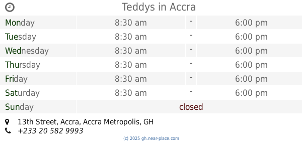
Teddys
9, 13th Street, Accra
Clothing store
read more
📑
all categories
Accounting
Administrative area level 1
Administrative area level 2
Airport
Amusement park
Aquarium
Art gallery
Atm
Bakery
Bank
Bar
Beauty salon
Bicycle store
Book store
Bus station
Cafe
Campground
Car dealer
Car rental
Car repair
Car wash
Casino
Cemetery
Church
City hall
Clothing store
Colloquial area
Convenience store
Courthouse
Dentist
Department store
Doctor
Electrician
Electronics store
Embassy
Finance
Fire station
Florist
Food
Funeral home
Furniture store
Gas station
General contractor
Grocery or supermarket
Gym
Hair care
Hardware store
Health
Hindu Temple
Home goods store
Hospital
Insurance agency
Intersection
Jewelry store
Laundry
Lawyer
Library
Liquor store
Local government office
Locality
Locksmith
Lodging
Meal delivery
Meal takeaway
Mosque
Movie rental
Movie theater
Moving company
Museum
Natural feature
Neighborhood
Night club
Painter
Park
Parking
Pet store
Pharmacy
Physiotherapist
Place of worship
Plumber
Point of interest
Police
Post office
Premise
Real estate agency
Restaurant
Roofing contractor
Route
Rv park, camping
School
Shoe store
Shopping mall
Spa
Stadium
Storage
Store
Subpremise
Subway station
Supermarket
Synagogue
Taxi stand
Train station
Transit station
Travel agency
University
Veterinary care
Zoo
sublocality level 1
↑