Clothing store nearby God Is Able Fashion
Ghana
Clothing store nearby God Is Able Fashion
God Is Able Fashion
Ghana Ghana
contacts phone
:
+233
Latitude:
5.5405659
, Longitude:
-0.2563283
read more
nearest Clothing store
249 m
Ladies (Silas Boutique) Gents
Ghana
Clothing store
read more
323 m
Fashion Lounge Boutique
Banana inn
Clothing store
read more
343 m
Ikeppau Garment
Chemu Road, Accra
Clothing store
read more
404 m
Hybrid Clothing
Guggisberg Avenue, Accra
Clothing store
read more
605 m
Gina's Best-goodies parlour
dansoman, hansonic road
Clothing store
read more
626 m
Angie's Kollections
Dansoman Market, Opposite Gold House, Accra
Clothing store
read more
634 m
Verbiss Enterprise
P. O. Box 1037, Accra
Clothing store
read more
686 m
Nanaba Garment and Trading ENT
Accra
Clothing store
read more
718 m
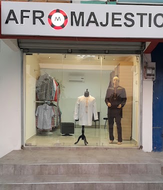
Afro Majestic
Accra
Clothing store
read more
772 m
Gillette Solutions, DC
Accra
Clothing store
read more
840 m
Terrycoff Arts
Near Mascot Hotel, 2 Titus Street, Accra
Clothing store
read more
924 m
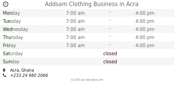
Addsam Clothing Business
Accra
Clothing store
read more
1.066 km
Samuel Ofori Collections
Pentecost Dansoman
Clothing store
read more
1.069 km
The Hog Shop
6 22nd Street, Accra
Clothing store
read more
1.078 km
Essence Kids
6 22nd Street, Accra
Clothing store
read more
1.078 km
Essence Kids
Ghana
Clothing store
read more
1.107 km
Zoe's Kids Collections
Dansoman High Street, Accra
Clothing store
read more
1.607 km
Yawa Clothing
Ghana
Clothing store
read more
1.641 km
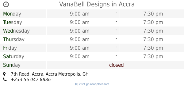
VanaBell Designs
5°33'08.7"N 0°15'54., 7th Road, Accra
Clothing store
read more
1.846 km
Crossgate Boutique
Dansoman High Street, Accra
Clothing store
read more
1.966 km
No Problem The Best T-Shirt
Ghana
Clothing store
read more
2.254 km
J & B Boutique
Brigade Road, Accra
Clothing store
read more
2.493 km
ekhooks fashion house
Accra
Clothing store
read more
2.494 km
Sarah Fabrics
Accra
Clothing store
read more
2.609 km
Tatiyana Curves
Accra
Clothing store
read more
📑
all categories
Accounting
Administrative area level 1
Administrative area level 2
Airport
Amusement park
Aquarium
Art gallery
Atm
Bakery
Bank
Bar
Beauty salon
Bicycle store
Book store
Bus station
Cafe
Campground
Car dealer
Car rental
Car repair
Car wash
Casino
Cemetery
Church
City hall
Clothing store
Colloquial area
Convenience store
Courthouse
Dentist
Department store
Doctor
Electrician
Electronics store
Embassy
Finance
Fire station
Florist
Food
Funeral home
Furniture store
Gas station
General contractor
Grocery or supermarket
Gym
Hair care
Hardware store
Health
Hindu Temple
Home goods store
Hospital
Insurance agency
Intersection
Jewelry store
Laundry
Lawyer
Library
Liquor store
Local government office
Locality
Locksmith
Lodging
Meal delivery
Meal takeaway
Mosque
Movie rental
Movie theater
Moving company
Museum
Natural feature
Neighborhood
Night club
Painter
Park
Parking
Pet store
Pharmacy
Physiotherapist
Place of worship
Plumber
Point of interest
Police
Post office
Premise
Real estate agency
Restaurant
Roofing contractor
Route
Rv park, camping
School
Shoe store
Shopping mall
Spa
Stadium
Storage
Store
Subpremise
Subway station
Supermarket
Synagogue
Taxi stand
Train station
Transit station
Travel agency
University
Veterinary care
Zoo
sublocality level 1
↑