Hospital nearby Standard Chartered Hospital
Ghana
Hospital nearby Standard Chartered Hospital
Standard Chartered Hospital
Accra Ghana
contacts phone
:
+233
Latitude:
5.5522069
, Longitude:
-0.2086303
read more
nearest Hospital
212 m
SIC Bob Freeman clinic
Kojo Thompson Road, Accra
Hospital
read more
242 m
C & J Hospital
Accra
Hospital
read more
337 m
Swanzy medical center
South Industrial Area, Accra
Hospital
read more
497 m
Kojach Medicare Diagnostic Centre
D-747 7, Okaishie, Kimberly Avenue, Accra
Hospital
read more
523 m
Nyaho Medical Centre, Accra Central
Barnes Road, The Octagon, Block, Accra
Hospital
read more
735 m
Medical eye Centre
Liberia Road, Accra
Hospital
read more
806 m
Graphic Clinic
West Ridge, Accra
Hospital
read more
929 m
atta quarshie morton memorial hospital
Kwame Nkrumah Avenue, Accra
Hospital
read more
970 m
Children's Hospital
Akra
Hospital
read more
970 m
Children's Hospital
Acra
Hospital
read more
970 m
Children's Hospital
Accra
Hospital
read more
996 m
Princess Marie Louise Children's Hospital
Derby Avenue, Accra
Hospital
read more
1.061 km
Korle Bu Teaching Hospital
Amoonakwa Road, Accra
Hospital
read more
1.086 km
Odorna Medical Centre
Adama Ave Accra Republic of
Hospital
read more
1.116 km
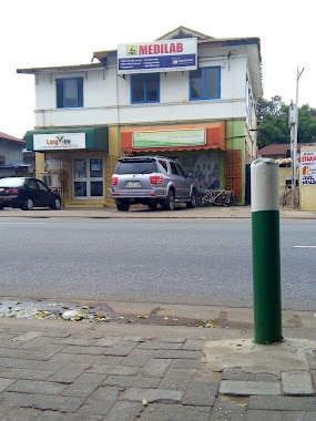
Medilab
85 Kojo Thompson Road, Accra
Hospital
read more
1.329 km
Accra Psychiatric Hospital
Castle Road, Accra
Hospital
read more
1.383 km
Civil Service Clinic
Finance Drive, Accra
Hospital
read more
1.401 km
Civil Service Polyclinic
28 February Road, Ministries, Accra
Hospital
read more
1.501 km
Greater Accra Regional Hospital
Castle Road, Accra
Hospital
read more
1.793 km
Iran Clinic
Kojo Thompson Road, Accra
Hospital
read more
1.954 km
Bank of Ghana Clinic
Accra
Hospital
read more
2.084 km
MedFocus International
Sam Nujoma Road, Accra
Hospital
read more
2.253 km
Korle-Bu Fevers Unit
Ghana, Accra
Hospital
read more
2.38 km
Korle Bu Polyclinic
Accra
Hospital
read more
2.393 km
Korle Bu Medical ICU
Ashiedu Keteke Sub-Metro, Accra
Hospital
read more
📑
all categories
Accounting
Administrative area level 1
Administrative area level 2
Airport
Amusement park
Aquarium
Art gallery
Atm
Bakery
Bank
Bar
Beauty salon
Bicycle store
Book store
Bus station
Cafe
Campground
Car dealer
Car rental
Car repair
Car wash
Casino
Cemetery
Church
City hall
Clothing store
Colloquial area
Convenience store
Courthouse
Dentist
Department store
Doctor
Electrician
Electronics store
Embassy
Finance
Fire station
Florist
Food
Funeral home
Furniture store
Gas station
General contractor
Grocery or supermarket
Gym
Hair care
Hardware store
Health
Hindu Temple
Home goods store
Hospital
Insurance agency
Intersection
Jewelry store
Laundry
Lawyer
Library
Liquor store
Local government office
Locality
Locksmith
Lodging
Meal delivery
Meal takeaway
Mosque
Movie rental
Movie theater
Moving company
Museum
Natural feature
Neighborhood
Night club
Painter
Park
Parking
Pet store
Pharmacy
Physiotherapist
Place of worship
Plumber
Point of interest
Police
Post office
Premise
Real estate agency
Restaurant
Roofing contractor
Route
Rv park, camping
School
Shoe store
Shopping mall
Spa
Stadium
Storage
Store
Subpremise
Subway station
Supermarket
Synagogue
Taxi stand
Train station
Transit station
Travel agency
University
Veterinary care
Zoo
sublocality level 1
↑