Night club nearby Coltrane Jazz Club
Ghana
Night club nearby Coltrane Jazz Club
Coltrane Jazz Club
Adenta Municipality, Ghana
contacts phone
:
+233 24 438 3252
website:
www.coltranejazzclub.com
Latitude:
5.7080465
, Longitude:
-0.166077
larger map & directions
read more
nearest Night club
1.009 km
Hush Lounge
Ghana
Night club
read more
2.971 km
Club Kudjoe
North, Legon
Night club
read more
3.501 km
Pagayouth Club
Madina
Night club
read more
4.008 km
ParDees nite club
Madina
Night club
read more
4.242 km
C&J Pub and Lounge
Madina
Night club
read more
4.295 km
Cylabite Healthy Alternatives
Ghana
Night club
read more
6.662 km
Knk Deals
Madina
Night club
read more
7.338 km
Paparazzi Lounge
1 Cotton Street, Accra
Night club
read more
7.362 km
TRUTH ALL BLACK PARTY
2-16, Cotton Street, Accra
Night club
read more
7.949 km
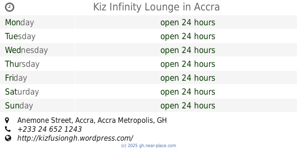
Kiz Infinity Lounge
Anemone Street, Accra
Night club
read more
8.263 km
Bill and Jeanne Bliss Student Lounge
University Avenue
Night club
read more
9.692 km
The Snack Lounge
Parakuo Estates, Accra
Night club
read more
10.23 km
Jazz Tone
Senchi Street, Accra
Night club
read more
10.801 km
Exel Exclusive Lounge
# 45, Kofi Annan Street, Accra
Night club
read more
11.827 km
Sky Bar
Accra
Night club
read more
12.163 km
Carbon Nightclub
Airport City, Accra
Night club
read more
12.875 km
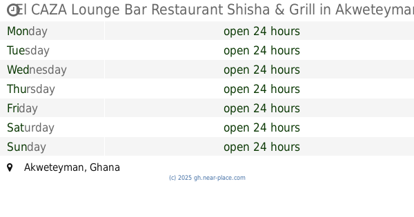
El CAZA Lounge Bar Restaurant Shisha & Grill
Akweteyman
Night club
read more
13.575 km
Exceptional Ladies Investment Club
Cantonment, Jawaharlal Nehru Road, Accra
Night club
read more
14.468 km
Society Builders' Club
Old Fort Link Road, Accra
Night club
read more
14.521 km
Gumzang Night Club
Ashaiman, Tema
Night club
read more
14.978 km
Club Onyx
Osu Avenue Extension, Accra
Night club
read more
15.07 km
City Bar And Grill
Fourth Mukose Link, Accra
Night club
read more
16.05 km
Billy Jane Night Club
Accra
Night club
read more
16.151 km
PM's Lounge And Bar
Orgle Road, Accra
Night club
read more
16.791 km
+10 Pub & Shisha Lounge
Night club
read more
📑
all categories
Accounting
Administrative area level 1
Administrative area level 2
Airport
Amusement park
Aquarium
Art gallery
Atm
Bakery
Bank
Bar
Beauty salon
Bicycle store
Book store
Bus station
Cafe
Campground
Car dealer
Car rental
Car repair
Car wash
Casino
Cemetery
Church
City hall
Clothing store
Colloquial area
Convenience store
Courthouse
Dentist
Department store
Doctor
Electrician
Electronics store
Embassy
Finance
Fire station
Florist
Food
Funeral home
Furniture store
Gas station
General contractor
Grocery or supermarket
Gym
Hair care
Hardware store
Health
Hindu Temple
Home goods store
Hospital
Insurance agency
Intersection
Jewelry store
Laundry
Lawyer
Library
Liquor store
Local government office
Locality
Locksmith
Lodging
Meal delivery
Meal takeaway
Mosque
Movie rental
Movie theater
Moving company
Museum
Natural feature
Neighborhood
Night club
Painter
Park
Parking
Pet store
Pharmacy
Physiotherapist
Place of worship
Plumber
Point of interest
Police
Post office
Premise
Real estate agency
Restaurant
Roofing contractor
Route
Rv park, camping
School
Shoe store
Shopping mall
Spa
Stadium
Storage
Store
Subpremise
Subway station
Supermarket
Synagogue
Taxi stand
Train station
Transit station
Travel agency
University
Veterinary care
Zoo
sublocality level 1
↑