Pharmacy nearby Health Box Pharmacy
Ghana
Pharmacy nearby Health Box Pharmacy
Health Box Pharmacy
Ghana Ghana
contacts phone
:
+233
Latitude:
5.6010973
, Longitude:
-0.108074
read more
nearest Pharmacy
279 m
Peniel Pharmacy
Accra
Pharmacy
read more
480 m
VICMAG PHAMARCY LTD
Accra
Pharmacy
read more
807 m
Jim-Beck Pharmacy Gh. Ltd.
Ghana
Pharmacy
read more
829 m
Health Consult Pharmacy
Accra
Pharmacy
read more
967 m
Samsel Pharmacy
Ghana
Pharmacy
read more
967 m
Samsel Pharmacy
2 Tsui Bleoo Road, Accra
Pharmacy
read more
1.074 km
BRIGHT PHARMACY
Accra
Pharmacy
read more
1.128 km
Elshadai
Accra
Pharmacy
read more
1.191 km
Pelben Pharmacy
Ghana
Pharmacy
read more
1.304 km
Pro-life Pharmacy
Accra
Pharmacy
read more
1.456 km
Atako Licensed Chemical Store
Accra
Pharmacy
read more
1.52 km
Old Pro Life Pharmacy
Teshie, Accra
Pharmacy
read more
1.52 km
Old Pro Life Pharmacy
Teshie South, Accra
Pharmacy
read more
1.662 km
Biotic Pharmacy (Retail Division)
First Junction, Accra
Pharmacy
read more
1.746 km
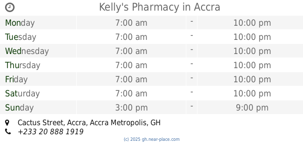
Kelly's Pharmacy
Cactus Street, Accra
Pharmacy
read more
1.761 km
Edivade Pharmacy Ltd.
Cactus Street, Accra
Pharmacy
read more
1.795 km
GLem Pharmacy
Coffie Street, Accra
Pharmacy
read more
1.834 km
PillPoint Pharmacy (Teshie)
Teshie Road, Accra
Pharmacy
read more
2.122 km
No Vime Pharmacy
Ghana
Pharmacy
read more
2.157 km
Mawudem Pharmacy
Agblezaa - Manet Road, Accra
Pharmacy
read more
2.171 km
Christian Pharmacy
Teshie Road, Accra
Pharmacy
read more
2.247 km
Coco Beach Road Pharmacy
Ghana
Pharmacy
read more
2.304 km
Health Royale (Pharmacy Ltd.)
Ghana
Pharmacy
read more
2.482 km
Denaka Community Pharmacy
Martin Sowah's Road, Accra
Pharmacy
read more
2.629 km
Cedar Life Pharmacy
19 th boundary road okpoi gomno
Pharmacy
read more
📑
all categories
Accounting
Administrative area level 1
Administrative area level 2
Airport
Amusement park
Aquarium
Art gallery
Atm
Bakery
Bank
Bar
Beauty salon
Bicycle store
Book store
Bus station
Cafe
Campground
Car dealer
Car rental
Car repair
Car wash
Casino
Cemetery
Church
City hall
Clothing store
Colloquial area
Convenience store
Courthouse
Dentist
Department store
Doctor
Electrician
Electronics store
Embassy
Finance
Fire station
Florist
Food
Funeral home
Furniture store
Gas station
General contractor
Grocery or supermarket
Gym
Hair care
Hardware store
Health
Hindu Temple
Home goods store
Hospital
Insurance agency
Intersection
Jewelry store
Laundry
Lawyer
Library
Liquor store
Local government office
Locality
Locksmith
Lodging
Meal delivery
Meal takeaway
Mosque
Movie rental
Movie theater
Moving company
Museum
Natural feature
Neighborhood
Night club
Painter
Park
Parking
Pet store
Pharmacy
Physiotherapist
Place of worship
Plumber
Point of interest
Police
Post office
Premise
Real estate agency
Restaurant
Roofing contractor
Route
Rv park, camping
School
Shoe store
Shopping mall
Spa
Stadium
Storage
Store
Subpremise
Subway station
Supermarket
Synagogue
Taxi stand
Train station
Transit station
Travel agency
University
Veterinary care
Zoo
sublocality level 1
↑