Pharmacy nearby Kent pharmacy
Ghana
Pharmacy nearby Kent pharmacy
Kent pharmacy
Ghana
contacts phone
:
+233
Latitude:
5.6238506
, Longitude:
-0.2406468
larger map & directions
read more
nearest Pharmacy
581 m
Fidel Pharmacy
Ghana
Pharmacy
read more
714 m
Pharma Choice Pharmacy
Pharmacy
read more
722 m
Exxell Pharmacy
Pumpkin Avenue, Akweteyman
Pharmacy
read more
722 m
Exxell Pharma Ltd
Pumpkin Avenue, Akweteyman
Pharmacy
read more
834 m
Mile 7 Chemist Ltd
Justice A. Brobbey Avenue
Pharmacy
read more
987 m
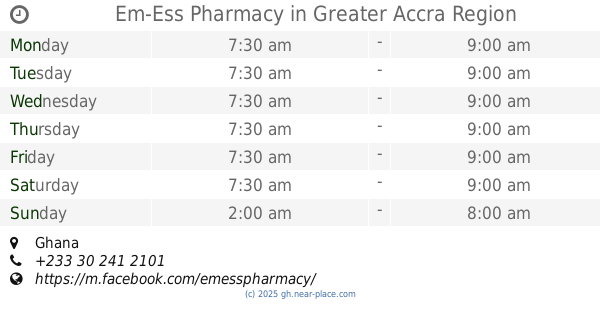
Em-Ess Pharmacy
Ghana
Pharmacy
read more
1.265 km
Emboch Pharmacy Achimota Mile 7, T - Junction
7, Achimota Road, Accra
Pharmacy
read more
1.513 km
Price Chemist Pharmacy
Nii Okaiman West Main Road
Pharmacy
read more
1.769 km
Josly Pharmacy Ltd.
Ghana
Pharmacy
read more
1.796 km
Premier Pharmacy Ltd
Nii Okaiman East
Pharmacy
read more
1.824 km
Willer Pharmacy Ltd
Nii Okaiman West Main Road, Nii Okaiman East
Pharmacy
read more
1.826 km
Redemption Pharmaceuticals
354 Saint Johns - Dome - Kwabenya - Brekusu Road, Accra
Pharmacy
read more
1.917 km
Op Pharmacy
Ghana
Pharmacy
read more
1.975 km
Imorich Enterprise
Accra
Pharmacy
read more
2.088 km
Dzofam Pharmacy
Christian Village, Accra
Pharmacy
read more
2.194 km
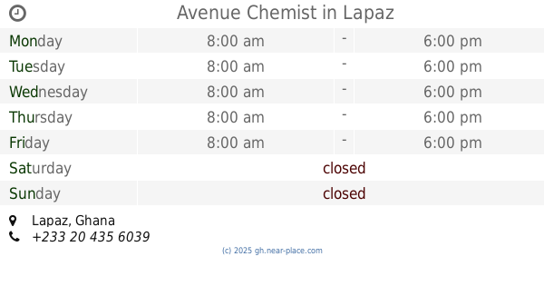
Avenue Chemist
Lapaz
Pharmacy
read more
2.305 km
Prijo Pharmacy
Pharmacy
read more
2.473 km
Dufie Chemicals
Accra
Pharmacy
read more
2.581 km
Big Maron Pharmacy
Accra Lapaz, New Market
Pharmacy
read more
2.65 km
Medcare Pharmacy
Fadama Road, Accra
Pharmacy
read more
2.893 km
Willy G Pharmacy
Pharmacy
read more
3.025 km
Danslob Pharmacy Limited
Ghana
Pharmacy
read more
3.025 km
Danslob Pharmacy Limited
Pharmacy
read more
3.176 km
Bamel Pharmacy
10th Avenue, Accra
Pharmacy
read more
3.191 km
Avenue Chemist
10th Avenue, Accra
Pharmacy
read more
📑
all categories
Accounting
Administrative area level 1
Administrative area level 2
Airport
Amusement park
Aquarium
Art gallery
Atm
Bakery
Bank
Bar
Beauty salon
Bicycle store
Book store
Bus station
Cafe
Campground
Car dealer
Car rental
Car repair
Car wash
Casino
Cemetery
Church
City hall
Clothing store
Colloquial area
Convenience store
Courthouse
Dentist
Department store
Doctor
Electrician
Electronics store
Embassy
Finance
Fire station
Florist
Food
Funeral home
Furniture store
Gas station
General contractor
Grocery or supermarket
Gym
Hair care
Hardware store
Health
Hindu Temple
Home goods store
Hospital
Insurance agency
Intersection
Jewelry store
Laundry
Lawyer
Library
Liquor store
Local government office
Locality
Locksmith
Lodging
Meal delivery
Meal takeaway
Mosque
Movie rental
Movie theater
Moving company
Museum
Natural feature
Neighborhood
Night club
Painter
Park
Parking
Pet store
Pharmacy
Physiotherapist
Place of worship
Plumber
Point of interest
Police
Post office
Premise
Real estate agency
Restaurant
Roofing contractor
Route
Rv park, camping
School
Shoe store
Shopping mall
Spa
Stadium
Storage
Store
Subpremise
Subway station
Supermarket
Synagogue
Taxi stand
Train station
Transit station
Travel agency
University
Veterinary care
Zoo
sublocality level 1
↑