Pharmacy nearby Kokrobite Drug Store
Ghana
Pharmacy nearby Kokrobite Drug Store
Kokrobite Drug Store
Kokrobite Ghana
contacts phone
:
+233
Latitude:
5.499091
, Longitude:
-0.364994
read more
nearest Pharmacy
3.566 km
Livingstone Chemist Licensed Chemical Shop
Ghana
Pharmacy
read more
5.745 km
Rakmor Pharmacy
Ghana
Pharmacy
read more
9.083 km
Peace Licenced Chemical Shop
Djama Road
Pharmacy
read more
10.519 km
All Aid Pharmacy
Kasoa
Pharmacy
read more
11.61 km
PillPoint Pharmacy - Mallam
Mallam
Pharmacy
read more
11.801 km
Netab Pharmacy
Gbawe Road, Mallam
Pharmacy
read more
11.819 km
Pharmacy Metropharm Ltd.
Gbawe Road
Pharmacy
read more
11.902 km
Triple B Pharmacy
Obonu Road, Accra
Pharmacy
read more
12.633 km
Lifedoor Pharmacy Ltd
Sankofa Avenue, Accra
Pharmacy
read more
12.653 km
Ranedy Pharmacy
Woowoti Street, Accra
Pharmacy
read more
13.132 km
Neo Aid Pharmacy
136 General Ankrah High Street, Accra
Pharmacy
read more
13.447 km
PillPoint Pharmacy - Awoshie
Pharmacy
read more
13.898 km
Salby Pharmacy
Dansoman, Accra
Pharmacy
read more
13.957 km
Link Pharmacy
Dansoman Road, Accra
Pharmacy
read more
14.253 km
Hendino Pharmacy
Sakumo Crescent, Accra
Pharmacy
read more
14.714 km
RadiMed Chemist
Ghana
Pharmacy
read more
15.338 km
Lifeline Chemists
Nii Amasa Street, Accra
Pharmacy
read more
15.428 km
Romart Pharmacy Annex
santa maria, last stop
Pharmacy
read more
15.529 km
Gina Chemicals Shop
Pharmacy
read more
15.752 km
Krisdof Pharmacy
Korlebu Street, Accra
Pharmacy
read more
16.419 km
Unichem Industries Limited
Bubuashie,, Agbon Boi Street, Accra
Pharmacy
read more
17.548 km
Medcare Pharmacy
Fadama Road, Accra
Pharmacy
read more
18.402 km
Bamel Pharmacy
10th Avenue, Accra
Pharmacy
read more
19.168 km
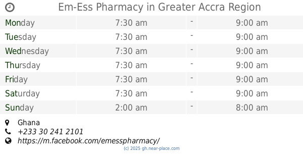
Em-Ess Pharmacy
Ghana
Pharmacy
read more
19.262 km
Fidel Pharmacy
Ghana
Pharmacy
read more
📑
all categories
Accounting
Administrative area level 1
Administrative area level 2
Airport
Amusement park
Aquarium
Art gallery
Atm
Bakery
Bank
Bar
Beauty salon
Bicycle store
Book store
Bus station
Cafe
Campground
Car dealer
Car rental
Car repair
Car wash
Casino
Cemetery
Church
City hall
Clothing store
Colloquial area
Convenience store
Courthouse
Dentist
Department store
Doctor
Electrician
Electronics store
Embassy
Finance
Fire station
Florist
Food
Funeral home
Furniture store
Gas station
General contractor
Grocery or supermarket
Gym
Hair care
Hardware store
Health
Hindu Temple
Home goods store
Hospital
Insurance agency
Intersection
Jewelry store
Laundry
Lawyer
Library
Liquor store
Local government office
Locality
Locksmith
Lodging
Meal delivery
Meal takeaway
Mosque
Movie rental
Movie theater
Moving company
Museum
Natural feature
Neighborhood
Night club
Painter
Park
Parking
Pet store
Pharmacy
Physiotherapist
Place of worship
Plumber
Point of interest
Police
Post office
Premise
Real estate agency
Restaurant
Roofing contractor
Route
Rv park, camping
School
Shoe store
Shopping mall
Spa
Stadium
Storage
Store
Subpremise
Subway station
Supermarket
Synagogue
Taxi stand
Train station
Transit station
Travel agency
University
Veterinary care
Zoo
sublocality level 1
↑