Pharmacy nearby Medical Stores
Ghana
Pharmacy nearby Medical Stores
Medical Stores
Koforidua Ghana
contacts phone
:
+233
Latitude:
6.0723728
, Longitude:
-0.2485644
read more
nearest Pharmacy
415 m
Max Hope Pharmacy
Ghana
Pharmacy
read more
2.278 km
Kama Pharmacy
Koforidua
Pharmacy
read more
2.375 km
ANCASTER PHARMACY
Koforidua Central Business District, Koforidua
Pharmacy
read more
2.493 km
Gabson Pharmacy ltd
Koforidua
Pharmacy
read more
2.613 km
Eastern Chemist Ltd
Nsukwao Road, Koforidua
Pharmacy
read more
2.691 km
Ernest Chemists Limited - Koforidua Branch
Koforidua Central Business District, Koforidua
Pharmacy
read more
2.862 km
Eastern Chemists Ltd
Ghana
Pharmacy
read more
3.101 km
Eastern Chemist
Koforidua
Pharmacy
read more
3.289 km
Joseph Amissah Pharmaceuticals
Koforidua
Pharmacy
read more
3.934 km
Roman Pharmacy Ltd.
Ghana
Pharmacy
read more
22.349 km
Providence Pharmacy LTD
Unnamed Road, Suhum
Pharmacy
read more
22.734 km
Tonykay Pharmacy Ltd.
Suhum-Koforidua Road, Suhum
Pharmacy
read more
23.046 km
Philly Chemicals
Suhum
Pharmacy
read more
40.605 km
24/7 Mother-Love Pharmacy
Adenta Municipality
Pharmacy
read more
44.502 km
Emerald Pharmacy
Ghana
Pharmacy
read more
45.372 km
CS Allot Pharmacy
Haatso-Atomic Road, Haatso
Pharmacy
read more
45.38 km
Radiance Pharmacy
Ghana
Pharmacy
read more
45.692 km
Crystal Tabs Pharmacy
49 Saint Johns - Dome - Kwabenya - Brekusu Road, Taifa
Pharmacy
read more
46.528 km
Leticia Aryee Pharmacy
Pharmacy
read more
47.073 km
Danslob Pharmacy Limited
Pharmacy
read more
47.359 km
Ajolah Chemical Store
Lebanon
Pharmacy
read more
49.228 km
Dr Sackey Veterinary Clinic
2nd Dr Tagoe Street, Accra
Pharmacy
read more
49.506 km
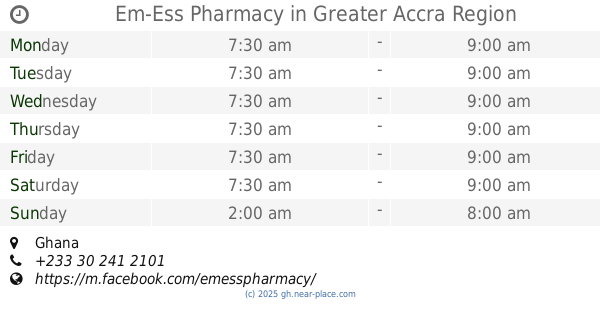
Em-Ess Pharmacy
Ghana
Pharmacy
read more
51.084 km
Pills n Tabs Pharmacy - Spintex Branch
5°38'10.6"N 0°06'11., 4th Avenue, Accra
Pharmacy
read more
51.329 km
Ernest Chemists Limited
Sixth Avenue, Tema
Pharmacy
read more
📑
all categories
Accounting
Administrative area level 1
Administrative area level 2
Airport
Amusement park
Aquarium
Art gallery
Atm
Bakery
Bank
Bar
Beauty salon
Bicycle store
Book store
Bus station
Cafe
Campground
Car dealer
Car rental
Car repair
Car wash
Casino
Cemetery
Church
City hall
Clothing store
Colloquial area
Convenience store
Courthouse
Dentist
Department store
Doctor
Electrician
Electronics store
Embassy
Finance
Fire station
Florist
Food
Funeral home
Furniture store
Gas station
General contractor
Grocery or supermarket
Gym
Hair care
Hardware store
Health
Hindu Temple
Home goods store
Hospital
Insurance agency
Intersection
Jewelry store
Laundry
Lawyer
Library
Liquor store
Local government office
Locality
Locksmith
Lodging
Meal delivery
Meal takeaway
Mosque
Movie rental
Movie theater
Moving company
Museum
Natural feature
Neighborhood
Night club
Painter
Park
Parking
Pet store
Pharmacy
Physiotherapist
Place of worship
Plumber
Point of interest
Police
Post office
Premise
Real estate agency
Restaurant
Roofing contractor
Route
Rv park, camping
School
Shoe store
Shopping mall
Spa
Stadium
Storage
Store
Subpremise
Subway station
Supermarket
Synagogue
Taxi stand
Train station
Transit station
Travel agency
University
Veterinary care
Zoo
sublocality level 1
↑