Restaurant nearby Auntie Mary's Beans Joint
Ghana
Restaurant nearby Auntie Mary's Beans Joint
Auntie Mary's Beans Joint
New Road, Madina, Accra Metropolis, GH Ghana
contacts phone
:
+233
Latitude:
5.6701651
, Longitude:
-0.1640493
larger map & directions
read more
nearest Restaurant
207 m
KINGS TREAT SERVICES
404 New Road, Madina
Restaurant
read more
211 m
Vien Inn Restaurant and Bar
Madina
Restaurant
read more
234 m
Ave Maria Restaurant
Madina
Restaurant
read more
248 m
Marfio's Kitchen
Madina
Restaurant
read more
265 m
Mama Lit Restaurant
Madina
Restaurant
read more
349 m
Demasfy California Eatery
Westland Boulevard Road, Madina
Restaurant
read more
410 m
Knightbridge House
Westland Boulevard Road, Madina
Restaurant
read more
413 m
moringa cottage house
mdn/163/1
Restaurant
read more
437 m
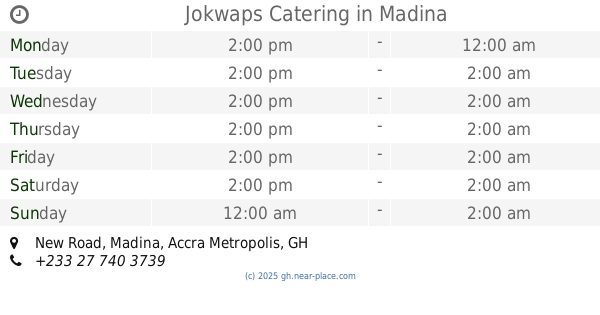
Jokwaps Catering
New Road, Madina
Restaurant
read more
437 m
Agatha's Perfect Taste l
Madina
Restaurant
read more
605 m
Agatha's Perfect Taste 2.0
Madina
Restaurant
read more
620 m
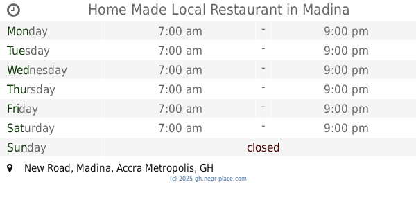
Home Made Local Restaurant
New Road, Madina
Restaurant
read more
641 m
Sky Filling Station Gym Centre
Unnamed Road, Madina
Restaurant
read more
743 m
Philipo's Tilapia Joint
University of professional studies
Restaurant
read more
780 m
Fulera Special
Madina
Restaurant
read more
785 m
Redd Lobster
Madina
Restaurant
read more
868 m
Mama Lit Catering Services
Boundary Road, Madina
Restaurant
read more
917 m
Mol's Kitchen
Agbotui Avenue, Madina
Restaurant
read more
919 m
Johnny King
Ghana
Restaurant
read more
1.029 km
JayDee Restaurant and Catering Services
Westland Boulevard Road, Madina
Restaurant
read more
1.037 km
Las Palmas
Madina
Restaurant
read more
1.14 km
Asante Home Touch
Madina
Restaurant
read more
1.569 km
African Kitchen
Madina
Restaurant
read more
1.745 km
Area Corner Pub
Madina
Restaurant
read more
2.289 km
Alvaro's
Accra
Restaurant
read more
📑
all categories
Accounting
Administrative area level 1
Administrative area level 2
Airport
Amusement park
Aquarium
Art gallery
Atm
Bakery
Bank
Bar
Beauty salon
Bicycle store
Book store
Bus station
Cafe
Campground
Car dealer
Car rental
Car repair
Car wash
Casino
Cemetery
Church
City hall
Clothing store
Colloquial area
Convenience store
Courthouse
Dentist
Department store
Doctor
Electrician
Electronics store
Embassy
Finance
Fire station
Florist
Food
Funeral home
Furniture store
Gas station
General contractor
Grocery or supermarket
Gym
Hair care
Hardware store
Health
Hindu Temple
Home goods store
Hospital
Insurance agency
Intersection
Jewelry store
Laundry
Lawyer
Library
Liquor store
Local government office
Locality
Locksmith
Lodging
Meal delivery
Meal takeaway
Mosque
Movie rental
Movie theater
Moving company
Museum
Natural feature
Neighborhood
Night club
Painter
Park
Parking
Pet store
Pharmacy
Physiotherapist
Place of worship
Plumber
Point of interest
Police
Post office
Premise
Real estate agency
Restaurant
Roofing contractor
Route
Rv park, camping
School
Shoe store
Shopping mall
Spa
Stadium
Storage
Store
Subpremise
Subway station
Supermarket
Synagogue
Taxi stand
Train station
Transit station
Travel agency
University
Veterinary care
Zoo
sublocality level 1
↑