Restaurant nearby DE KONSAB RESTAURANT
Ghana
Restaurant nearby DE KONSAB RESTAURANT
DE KONSAB RESTAURANT
Accra Ghana
contacts phone
:
+233
Latitude:
5.5818884
, Longitude:
-0.1865245
read more
nearest Restaurant
200 m
De Konsab
Old Grip Road, Accra
Restaurant
read more
333 m
Bamboo Chinese Fusion Restaurant
Switchback Crescent, Accra
Restaurant
read more
572 m
Molly's Kitchen
Tumu Avenue, Accra
Restaurant
read more
667 m
The Grillroom
Cantonments, Accra
Restaurant
read more
688 m
Clear Spice
Accra
Restaurant
read more
702 m
Afrikiko
Accra
Restaurant
read more
710 m
Afrikiko Leisure Centre
1st Csir Close, Accra
Restaurant
read more
712 m
Toro Tapas Bar
Presidential Drive, Accra
Restaurant
read more
746 m
Restaurante Tro Tapas Bar
Accra
Restaurant
read more
747 m
Mango And Wheat
Sunyani Avenue, Accra
Restaurant
read more
772 m
Fali's Hot Pot
Accra
Restaurant
read more
779 m
Taj Restaurant
Ayawaso East Sub Metro, Accra
Restaurant
read more
801 m
Toro Tapas Spanish Tapas Restaurant
Accra
Restaurant
read more
813 m
IL Pranzo Restaurant limited
Between WAEC and Children's Park Community Five,Tema Church Lane, Accra
Restaurant
read more
918 m
Curve Pub
2nd Estate Road, Accra
Restaurant
read more
922 m
Cocoa Board Club House
Accra
Restaurant
read more
946 m
Lunch City
Accra
Restaurant
read more
969 m
Mummy's Kitchen GH
Fourth Circular Road, Accra
Restaurant
read more
1.008 km
Ted's Place
Kade Avenue, Accra
Restaurant
read more
1.012 km
Addis Ababa
Sunyani Avenue, Accra
Restaurant
read more
1.089 km
The Cock Tail Mr. Rees
Airport Residential Area, Accra
Restaurant
read more
1.089 km
The Cock Tail Mr. Rees
Airport Area, Accra
Restaurant
read more
1.092 km
City Garden Korean Restaurant
Cantonments Crescent, Accra
Restaurant
read more
2.145 km
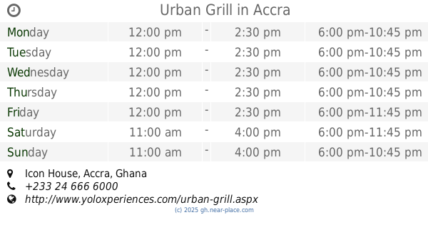
Urban Grill
Icon House, Accra
Restaurant
read more
2.393 km
R.A.A Catering Services
Accra
Restaurant
read more
📑
all categories
Accounting
Administrative area level 1
Administrative area level 2
Airport
Amusement park
Aquarium
Art gallery
Atm
Bakery
Bank
Bar
Beauty salon
Bicycle store
Book store
Bus station
Cafe
Campground
Car dealer
Car rental
Car repair
Car wash
Casino
Cemetery
Church
City hall
Clothing store
Colloquial area
Convenience store
Courthouse
Dentist
Department store
Doctor
Electrician
Electronics store
Embassy
Finance
Fire station
Florist
Food
Funeral home
Furniture store
Gas station
General contractor
Grocery or supermarket
Gym
Hair care
Hardware store
Health
Hindu Temple
Home goods store
Hospital
Insurance agency
Intersection
Jewelry store
Laundry
Lawyer
Library
Liquor store
Local government office
Locality
Locksmith
Lodging
Meal delivery
Meal takeaway
Mosque
Movie rental
Movie theater
Moving company
Museum
Natural feature
Neighborhood
Night club
Painter
Park
Parking
Pet store
Pharmacy
Physiotherapist
Place of worship
Plumber
Point of interest
Police
Post office
Premise
Real estate agency
Restaurant
Roofing contractor
Route
Rv park, camping
School
Shoe store
Shopping mall
Spa
Stadium
Storage
Store
Subpremise
Subway station
Supermarket
Synagogue
Taxi stand
Train station
Transit station
Travel agency
University
Veterinary care
Zoo
sublocality level 1
↑