Restaurant nearby Lawrencia's Restaurant
Ghana
Restaurant nearby Lawrencia's Restaurant
Lawrencia's Restaurant
Ghana Ghana
contacts phone
:
+233
Latitude:
5.700352
, Longitude:
-0.144502
read more
nearest Restaurant
595 m
Ensu Nyame Ye Food Joint
Ayaben Street, Adenta Municipality
Restaurant
read more
694 m
Village Canteen
Ghana
Restaurant
read more
704 m
The Icy Blus Spot
Ghana
Restaurant
read more
984 m
Trade Point
Madina
Restaurant
read more
1.344 km
Queens Tavern Bar & Restaurant
Adenta Municipality
Restaurant
read more
1.387 km
GRACIES Deli
South Boundry Road, Madina
Restaurant
read more
1.61 km
Favours Grill Restaurant
Adenta Municipality
Restaurant
read more
1.642 km
KENKEYCLASSICS
Adenta Municipality
Restaurant
read more
1.649 km
Halal Special
Ghana
Restaurant
read more
1.655 km
Sabali Special Shito
Adenta Municipality
Restaurant
read more
1.663 km
Akoto's Greens
Ghana
Restaurant
read more
1.725 km
Starbites Food and Drink
Ghana
Restaurant
read more
1.75 km
Checkers Inn
South Boundry Road, Madina
Restaurant
read more
1.753 km
CHECKERS RESTAURANT
Lake Side Estate, Ashaley Botwe
Restaurant
read more
1.819 km
Nanas Cottage
Ghana
Restaurant
read more
1.897 km
Tasty Chow Resturant
Adenta, Adenta Municipality
Restaurant
read more
1.965 km
Adenta Kenkey
Adenta Municipality
Restaurant
read more
2.047 km
Edenic Restaurant
Madina
Restaurant
read more
2.136 km
Just Eat Restaurant And Bar
Unnamed Road, Madina
Restaurant
read more
2.352 km
JUST FREDDIES
Adenta Municipality
Restaurant
read more
2.406 km
F-T TAWAKALTU ALLALAH
Adenta Municipality
Restaurant
read more
2.428 km
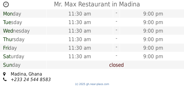
Mr. Max Restaurant
Madina
Restaurant
read more
2.463 km
Milani Fast Food
Madina
Restaurant
read more
2.488 km
Area Corner Pub
Madina
Restaurant
read more
2.493 km
Niisai Brown Gate
MAYE HOT, 114 Deedaw Ln, Madina
Restaurant
read more
📑
all categories
Accounting
Administrative area level 1
Administrative area level 2
Airport
Amusement park
Aquarium
Art gallery
Atm
Bakery
Bank
Bar
Beauty salon
Bicycle store
Book store
Bus station
Cafe
Campground
Car dealer
Car rental
Car repair
Car wash
Casino
Cemetery
Church
City hall
Clothing store
Colloquial area
Convenience store
Courthouse
Dentist
Department store
Doctor
Electrician
Electronics store
Embassy
Finance
Fire station
Florist
Food
Funeral home
Furniture store
Gas station
General contractor
Grocery or supermarket
Gym
Hair care
Hardware store
Health
Hindu Temple
Home goods store
Hospital
Insurance agency
Intersection
Jewelry store
Laundry
Lawyer
Library
Liquor store
Local government office
Locality
Locksmith
Lodging
Meal delivery
Meal takeaway
Mosque
Movie rental
Movie theater
Moving company
Museum
Natural feature
Neighborhood
Night club
Painter
Park
Parking
Pet store
Pharmacy
Physiotherapist
Place of worship
Plumber
Point of interest
Police
Post office
Premise
Real estate agency
Restaurant
Roofing contractor
Route
Rv park, camping
School
Shoe store
Shopping mall
Spa
Stadium
Storage
Store
Subpremise
Subway station
Supermarket
Synagogue
Taxi stand
Train station
Transit station
Travel agency
University
Veterinary care
Zoo
sublocality level 1
↑