Restaurant nearby Papaye Fast Food
Ghana
Restaurant nearby Papaye Fast Food
Papaye Fast Food
Accra Ghana
contacts phone
:
+233
Latitude:
5.6086691
, Longitude:
-0.2271519
read more
nearest Restaurant
364 m
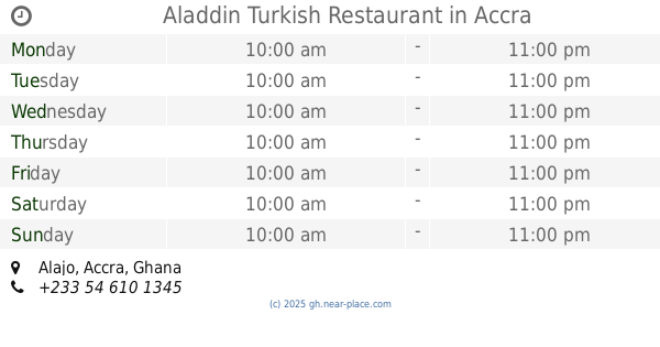
Aladdin Turkish Restaurant
Alajo, Accra
Restaurant
read more
462 m
Marwako Abelemkpe
Swaniker Street, Accra
Restaurant
read more
476 m
Marwako - Abelempke
Accra
Restaurant
read more
477 m
Jehovah Is My Friend Restaurant
Accra
Restaurant
read more
527 m
Insha Allah (Food Joint)
Ghana
Restaurant
read more
576 m
Chibuaku Restaurant
53 Onyankle Street, Accra
Restaurant
read more
613 m
Chez Sébastien
Ninth Road, Accra
Restaurant
read more
658 m
Tasty Grills Restaurant Gh.
Accra
Restaurant
read more
702 m
Alladin Turkish Restaurants
1st Tesano Crescent, Accra
Restaurant
read more
714 m
Abena Special
Trotro Street, Accra
Restaurant
read more
732 m
Midunu House
21, Sixth Road, Accra
Restaurant
read more
847 m
Hajia Garage
8 Trotro Street, Accra
Restaurant
read more
850 m
African Cho Bar
Swaniker Street, Accra
Restaurant
read more
860 m
LEZER FOODS
Accra
Restaurant
read more
904 m
Grab & Go
Alajo, Accra
Restaurant
read more
955 m
Chibuaku Restaurant
Abelemkpe Street, Accra
Restaurant
read more
1.001 km
Zchris Enterprise
Nsawam Road Link, Accra
Restaurant
read more
1.016 km
Green Pepper
Abeka Junction, Accra
Restaurant
read more
1.029 km
Las Palmas Restaurant Achimota
Accra
Restaurant
read more
1.106 km
Village Inn
Santana Road, Accra
Restaurant
read more
1.201 km
Golden Key Club And Restaurant
Accra
Restaurant
read more
1.227 km
Commodore Country Kitchen
36 Onyankle Street, Accra
Restaurant
read more
1.253 km
McKay's Pub & Restaurant
Accra
Restaurant
read more
1.985 km
In The Name of Allah
Fadama Road, Accra
Restaurant
read more
2.248 km
D-Flex Foods Chinese And Continental
Fadama Road, Accra
Restaurant
read more
📑
all categories
Accounting
Administrative area level 1
Administrative area level 2
Airport
Amusement park
Aquarium
Art gallery
Atm
Bakery
Bank
Bar
Beauty salon
Bicycle store
Book store
Bus station
Cafe
Campground
Car dealer
Car rental
Car repair
Car wash
Casino
Cemetery
Church
City hall
Clothing store
Colloquial area
Convenience store
Courthouse
Dentist
Department store
Doctor
Electrician
Electronics store
Embassy
Finance
Fire station
Florist
Food
Funeral home
Furniture store
Gas station
General contractor
Grocery or supermarket
Gym
Hair care
Hardware store
Health
Hindu Temple
Home goods store
Hospital
Insurance agency
Intersection
Jewelry store
Laundry
Lawyer
Library
Liquor store
Local government office
Locality
Locksmith
Lodging
Meal delivery
Meal takeaway
Mosque
Movie rental
Movie theater
Moving company
Museum
Natural feature
Neighborhood
Night club
Painter
Park
Parking
Pet store
Pharmacy
Physiotherapist
Place of worship
Plumber
Point of interest
Police
Post office
Premise
Real estate agency
Restaurant
Roofing contractor
Route
Rv park, camping
School
Shoe store
Shopping mall
Spa
Stadium
Storage
Store
Subpremise
Subway station
Supermarket
Synagogue
Taxi stand
Train station
Transit station
Travel agency
University
Veterinary care
Zoo
sublocality level 1
↑