School nearby Cutiebridal Beauty School
Ghana
School nearby Cutiebridal Beauty School
Cutiebridal Beauty School
Mataheko, Accra Ghana
contacts phone
:
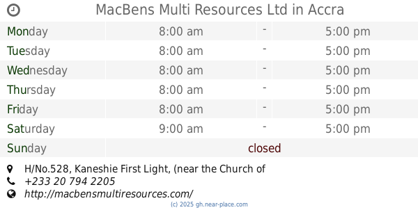
+233
Latitude:
5.5653317
, Longitude:
-0.2483025
read more
nearest School
503 m
Vertie Day Care
Mataheko, Accra
School
read more
514 m
Faith Evangelical Complex Schools
Mataheko, Accra
School
read more
545 m
Kateco
Mount Zion Street, Accra
School
read more
579 m
Grace Preparatory School, Kaneshie
Kaneshie 1st, Light
School
read more
654 m
Tina Kids
mataheko
School
read more
715 m
Mercy Kiddy Montessori Centre
Oblogo Road, Accra
School
read more
718 m
Val's Prep School
Akwadu Street, Accra
School
read more
739 m
Abossey Okai Roman Catholic Primary School
Nmenmete Walk, Accra
School
read more
774 m
JR Montessori Child Development Centre
Mataheko, Accra
School
read more
790 m
Kaneshie Shs Tech
Abosseyokai, Accra
School
read more
802 m
Holy Family Kindergarten
Mataheko, Accra
School
read more
807 m
Saint Pierre Claver
Abosseyokai, Accra
School
read more
809 m
MARS Business College
2nd Ponpon Street, Accra
School
read more
810 m
Haos Enterprise
Oblogo Road, Accra
School
read more
823 m
Mataheko Roman Catholic JHS
Jonkobri Road, Accra
School
read more
848 m
Seven Great Princes Academy
Oblogo Road, Accra
School
read more
849 m
Accra Academy
Winneba Road, Accra
School
read more
936 m
Lospat School Complex
Abosseyokai, Accra
School
read more
945 m
Media World
Mantse Boi Street, Accra
School
read more
952 m
MacBens Multi Resources Ltd
H/No.528, Kaneshie First Light, (near the Church of Pentecost- Kaneshie Central)
School
read more
969 m
Queens
Abosseyokai, Accra
School
read more
991 m
Odorkor MacLean Junior High School
Odorkor, Accra
School
read more
1.061 km
Newman Preparatory School
Accra
School
read more
1.09 km
OMG STUDIO
Odorkor, Accra
School
read more
1.121 km
EMMABS School
Odorkor, Accra
School
read more
📑
all categories
Accounting
Administrative area level 1
Administrative area level 2
Airport
Amusement park
Aquarium
Art gallery
Atm
Bakery
Bank
Bar
Beauty salon
Bicycle store
Book store
Bus station
Cafe
Campground
Car dealer
Car rental
Car repair
Car wash
Casino
Cemetery
Church
City hall
Clothing store
Colloquial area
Convenience store
Courthouse
Dentist
Department store
Doctor
Electrician
Electronics store
Embassy
Finance
Fire station
Florist
Food
Funeral home
Furniture store
Gas station
General contractor
Grocery or supermarket
Gym
Hair care
Hardware store
Health
Hindu Temple
Home goods store
Hospital
Insurance agency
Intersection
Jewelry store
Laundry
Lawyer
Library
Liquor store
Local government office
Locality
Locksmith
Lodging
Meal delivery
Meal takeaway
Mosque
Movie rental
Movie theater
Moving company
Museum
Natural feature
Neighborhood
Night club
Painter
Park
Parking
Pet store
Pharmacy
Physiotherapist
Place of worship
Plumber
Point of interest
Police
Post office
Premise
Real estate agency
Restaurant
Roofing contractor
Route
Rv park, camping
School
Shoe store
Shopping mall
Spa
Stadium
Storage
Store
Subpremise
Subway station
Supermarket
Synagogue
Taxi stand
Train station
Transit station
Travel agency
University
Veterinary care
Zoo
sublocality level 1
↑