School nearby King of Kings International School
Ghana
School nearby King of Kings International School
King of Kings International School
Blohum Road, Accra Ghana
contacts phone
:
+233
Latitude:
5.6121099
, Longitude:
-0.2028018
read more
nearest School
202 m
Learning Hive
Dzorwulu, Accra
School
read more
269 m
Dzworwulu Basic School
Dzorwulu, Accra
School
read more
283 m
Trinity Montessori School, Dzorwulu
Sapele Crescent, Accra
School
read more
322 m
Everlasting Peace Academy
Dzorwulu, Accra
School
read more
359 m
Edify Ghana
Dzorwulu Crescent, Accra
School
read more
380 m
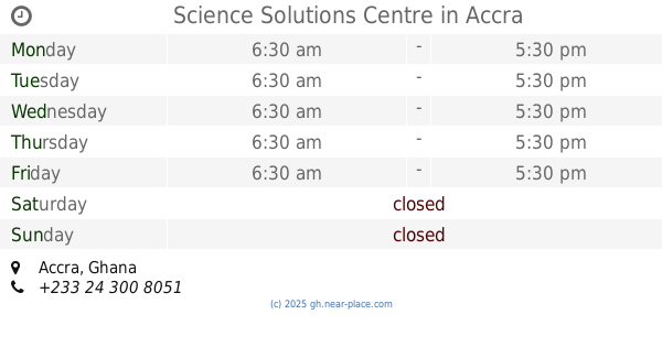
Science Solutions Centre
Accra
School
read more
409 m
Dzorwulu Special School
Kwabena Aniefe Street Number 1, Accra
School
read more
468 m
Joy Kids School
2nd Odotei Tsui Street, Accra
School
read more
471 m
Everlasting Peace Academy
Brown Link, Accra
School
read more
536 m
Frontline Petroleum Institute
Ghana highways Authority, No. 58 Nako House Second Floor, opp. Nogahil Hotel, George Walker Bush (N1) Ghana., Accra
School
read more
550 m
ASTRO TURF
Osu Bado Avenue, Accra
School
read more
584 m
Dzorwulu Primary A & B School
Ayawaso
School
read more
621 m
McAshley Driving School
Dzorwulu, Accra
School
read more
688 m
Little Flower Montessori School
Dzorwulu, Accra
School
read more
741 m
Pride Of The East School
Kpentenplebi Road, Accra
School
read more
795 m
Pfl Ghana
Accra
School
read more
800 m
Vichans School
Dzorwulu, Accra
School
read more
938 m
Redeemer Preparatory And Jhs
Ebony Crescent, Accra
School
read more
983 m
Alsyd Academy
Accra
School
read more
1.025 km
Prisons 1 and 2 School
Continental Crescent, Accra
School
read more
1.292 km
Lincoln Community School
N126/21, Accra
School
read more
1.497 km
Victoria Grammar School
8 Saflo Link, Accra
School
read more
1.656 km
Immanuel Restoration School Complex
Accra
School
read more
1.711 km
Abelemkpe Cluster Of Schools
Abelemkpe, Accra
School
read more
1.985 km
Cape Coast Univ
19 Patrice Lumumba Road, Accra
School
read more
📑
all categories
Accounting
Administrative area level 1
Administrative area level 2
Airport
Amusement park
Aquarium
Art gallery
Atm
Bakery
Bank
Bar
Beauty salon
Bicycle store
Book store
Bus station
Cafe
Campground
Car dealer
Car rental
Car repair
Car wash
Casino
Cemetery
Church
City hall
Clothing store
Colloquial area
Convenience store
Courthouse
Dentist
Department store
Doctor
Electrician
Electronics store
Embassy
Finance
Fire station
Florist
Food
Funeral home
Furniture store
Gas station
General contractor
Grocery or supermarket
Gym
Hair care
Hardware store
Health
Hindu Temple
Home goods store
Hospital
Insurance agency
Intersection
Jewelry store
Laundry
Lawyer
Library
Liquor store
Local government office
Locality
Locksmith
Lodging
Meal delivery
Meal takeaway
Mosque
Movie rental
Movie theater
Moving company
Museum
Natural feature
Neighborhood
Night club
Painter
Park
Parking
Pet store
Pharmacy
Physiotherapist
Place of worship
Plumber
Point of interest
Police
Post office
Premise
Real estate agency
Restaurant
Roofing contractor
Route
Rv park, camping
School
Shoe store
Shopping mall
Spa
Stadium
Storage
Store
Subpremise
Subway station
Supermarket
Synagogue
Taxi stand
Train station
Transit station
Travel agency
University
Veterinary care
Zoo
sublocality level 1
↑