Lodging nearby Ako Loop,Adenta-Housing down
Ghana
Lodging nearby Ako Loop,Adenta-Housing down
Ako Loop,Adenta-Housing down
Ako Loop, Greater Accra Region, GH Ghana
contacts phone
:
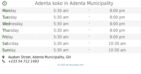
+233
Latitude:
5.7013936
, Longitude:
-0.1467802
larger map & directions
read more
nearest Lodging
83 m
Amalia's Sunrise Breakfast - ASB
Ayaben Street, Adenta Municipality
Lodging
read more
91 m
Adenta koko
58, Ayaben Street, Adenta Municipality
Lodging
read more
758 m
J & A Guest House
Ghana
Lodging
read more
1.05 km
Sir Bee Guest House
Adenta Municipality
Lodging
read more
1.06 km
Bineys Place
Greater Accra Region
Lodging
read more
1.274 km
Rasta Tee's Place
Bedzo Lane
Lodging
read more
1.418 km
Washington Heights Hotel Ltd
Adenta Municipality
Lodging
read more
1.57 km
Ensafoah Lodge
No. 3 Odoi Link, Adenta, Accra
Lodging
read more
1.633 km
Botchway Building
Ghana
Lodging
read more
1.639 km
EriKok Apartments
Adenta Municipality
Lodging
read more
1.639 km
Anoyeb Hotel
Adenta Municipality
Lodging
read more
1.736 km
Lakeside Place
Ghana
Lodging
read more
1.908 km
Dufie Apartments
Off No. Tma 0411, Adjacent Adenta Police Station, Adenta, Accra
Lodging
read more
1.919 km
Lonnie's House
Lake Side Estates
Lodging
read more
1.997 km
Lilyval Hotel
Unnamed Road GD-122-5793, Adentan
Lodging
read more
2.068 km
Sakdana Guest House
Arapajay Junction, Madina
Lodging
read more
2.07 km
Hedzorle Villa
Ashaley Botwe Old town Ashaley Botwe, Ashalebotwe
Lodging
read more
2.143 km
Paradise Lodge
No. 23 Gold Street, Dome
Lodging
read more
2.173 km
FBK Guest House
Madina Estate, Madina
Lodging
read more
2.273 km
Browne Hostel
124, Agbawe Avenue, Adenta Municipality
Lodging
read more
2.356 km
Adenta Frafraha
Kpeshie Road, Adenta Municipality
Lodging
read more
2.414 km
Ayebeas'
Madina
Lodging
read more
2.516 km
Royal Habiba Hotel
Madina
Lodging
read more
2.522 km
Ritz Hotel Approx.
Agblezaa - Manet Road, Accra
Lodging
read more
2.59 km
Hotel Feladei
Ghana
Lodging
read more
📑
all categories
Accounting
Administrative area level 1
Administrative area level 2
Airport
Amusement park
Aquarium
Art gallery
Atm
Bakery
Bank
Bar
Beauty salon
Bicycle store
Book store
Bus station
Cafe
Campground
Car dealer
Car rental
Car repair
Car wash
Casino
Cemetery
Church
City hall
Clothing store
Colloquial area
Convenience store
Courthouse
Dentist
Department store
Doctor
Electrician
Electronics store
Embassy
Finance
Fire station
Florist
Food
Funeral home
Furniture store
Gas station
General contractor
Grocery or supermarket
Gym
Hair care
Hardware store
Health
Hindu Temple
Home goods store
Hospital
Insurance agency
Intersection
Jewelry store
Laundry
Lawyer
Library
Liquor store
Local government office
Locality
Locksmith
Lodging
Meal delivery
Meal takeaway
Mosque
Movie rental
Movie theater
Moving company
Museum
Natural feature
Neighborhood
Night club
Painter
Park
Parking
Pet store
Pharmacy
Physiotherapist
Place of worship
Plumber
Point of interest
Police
Post office
Premise
Real estate agency
Restaurant
Roofing contractor
Route
Rv park, camping
School
Shoe store
Shopping mall
Spa
Stadium
Storage
Store
Subpremise
Subway station
Supermarket
Synagogue
Taxi stand
Train station
Transit station
Travel agency
University
Veterinary care
Zoo
sublocality level 1
↑