Lodging nearby BW
Ghana
Lodging nearby BW
BW
22, Patrice Lumumba Road, Accra, Accra Metropolis, GH Ghana
contacts phone
:
+233
Latitude:
5.6018916
, Longitude:
-0.1863813
larger map & directions
read more
nearest Lodging
151 m
BEST WESTERN PREMIER Accra Airport Hotel
17 Quartey Papafio Avenue, Accra
Lodging
read more
199 m
The Congress Hotel
Patrice Lumumba Road, Accra
Lodging
read more
202 m
Airport Residential Apartment
Quartey Papafio Avenue, Accra
Lodging
read more
213 m
Hotel Adinkra Lodge
Accra
Lodging
read more
213 m
Sunyani SSNIT
Airport Residential Area, Accra
Lodging
read more
213 m
CONSIR EXECUTIVE LODGE
Adjacent to HFC Head Office, Accra
Lodging
read more
213 m
ACCRA & SURROUNDINGS
Accra
Lodging
read more
213 m
Garden View Guest House
Road Leading Community 20, Accra
Lodging
read more
213 m
Sunyani SSNIT
Airport Area, Accra
Lodging
read more
313 m
Hotel Georgia
11 Patrice Lumumba Road, Accra
Lodging
read more
382 m
Hyatt Apartments Ghana
Unit B4, 13 Agostinho Neto Road, Accra
Lodging
read more
410 m
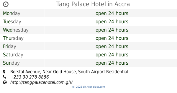
Tang Palace Hotel
Borstal Avenue, Near Gold House, South Airport Residential Area
Lodging
read more
428 m
Coconut Grove Hotels
Ridge Road, Accra
Lodging
read more
461 m
M Plaza Hotel
Borstal Ave Ln, Accra
Lodging
read more
869 m
Airside Hotel
45 Patrice Lumumba Road, Accra
Lodging
read more
869 m
Airside Hotel Hotel
45 Patrice Lumumba Road, Accra
Lodging
read more
894 m
Ghana Highway Authority Accommodation For Employees
no, 1st Onyasia Ln, Accra
Lodging
read more
910 m
Villa Monticello
No.1A Mankata Avenue Link, Accra
Lodging
read more
954 m
Ibis Style Hotel Airport Accra
24 North Airport Road, Accra
Lodging
read more
956 m
Airport View Hotel
Dr Amilcar Cabral Road, Accra
Lodging
read more
980 m
Asanko guest house
Roman Ridge, 10 Quarcoo lane, Accra
Lodging
read more
1.036 km
Esther Hotel
Patrice Lumumba Road, Accra
Lodging
read more
1.095 km
Lady In Red, Roman Ridge
Accra
Lodging
read more
1.129 km
Golden Tulip
Liberation Road, Accra
Lodging
read more
1.257 km
The Palms
Airport Residential Area, Accra
Lodging
read more
📑
all categories
Accounting
Administrative area level 1
Administrative area level 2
Airport
Amusement park
Aquarium
Art gallery
Atm
Bakery
Bank
Bar
Beauty salon
Bicycle store
Book store
Bus station
Cafe
Campground
Car dealer
Car rental
Car repair
Car wash
Casino
Cemetery
Church
City hall
Clothing store
Colloquial area
Convenience store
Courthouse
Dentist
Department store
Doctor
Electrician
Electronics store
Embassy
Finance
Fire station
Florist
Food
Funeral home
Furniture store
Gas station
General contractor
Grocery or supermarket
Gym
Hair care
Hardware store
Health
Hindu Temple
Home goods store
Hospital
Insurance agency
Intersection
Jewelry store
Laundry
Lawyer
Library
Liquor store
Local government office
Locality
Locksmith
Lodging
Meal delivery
Meal takeaway
Mosque
Movie rental
Movie theater
Moving company
Museum
Natural feature
Neighborhood
Night club
Painter
Park
Parking
Pet store
Pharmacy
Physiotherapist
Place of worship
Plumber
Point of interest
Police
Post office
Premise
Real estate agency
Restaurant
Roofing contractor
Route
Rv park, camping
School
Shoe store
Shopping mall
Spa
Stadium
Storage
Store
Subpremise
Subway station
Supermarket
Synagogue
Taxi stand
Train station
Transit station
Travel agency
University
Veterinary care
Zoo
sublocality level 1
↑