Lodging nearby Keegee Hotel
Ghana
Lodging nearby Keegee Hotel
Keegee Hotel
Alhaji Road, Accra, Accra Metropolis, GH Ghana
contacts phone
:
+233 30 240 0893
Latitude:
5.631733
, Longitude:
-0.2581039
larger map & directions
read more
nearest Lodging
403 m
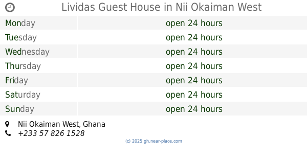
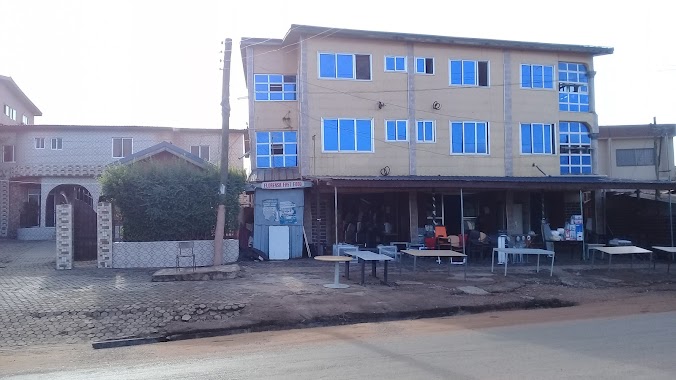
Lividas Guest House
Nii Okaiman West
Lodging
read more
570 m
Mountain Guest Limited
Ghana
Lodging
read more
594 m
Hotel Mountain Guest Limited
Chantan T-Junction, New Achimota, Accra
Lodging
read more
610 m
Florensa Hotel
Chantan-Isreal, Achimota
Lodging
read more
846 m
Sun Splash Hotel
Accra
Lodging
read more
852 m
CRISTAL CROWN HOTEL
Lodging
read more
915 m
Pazzys villa
Lodging
read more
1.016 km
Achimota
125 tantra hills
Lodging
read more
1.035 km
K&D Hotel
Star Junction, Tabora, Accra
Lodging
read more
1.208 km
Milton Hotel
Nii Okaiman West Main Road
Lodging
read more
1.278 km
Palm Plaza Bar and Restaurant
Ghana
Lodging
read more
1.367 km
Bronx View Hotel
Ginger Street, Accra
Lodging
read more
1.415 km
Kings Premier Lodge
16th Street New, Achimota
Lodging
read more
1.471 km
Mazibs International Hostel
Sowutoum
Lodging
read more
1.481 km
Dongola Villa
Nii Okaiman West
Lodging
read more
1.482 km
Detemple Hotel
Ghana
Lodging
read more
1.591 km
Googley Hostel
Sowutoum
Lodging
read more
1.726 km
Filly's Guest house
Off First Lane, Tantra Street, Accra
Lodging
read more
1.812 km
Adomah's Hostel
Sowutoum
Lodging
read more
1.913 km
Akokoraba Hostel
Ghana
Lodging
read more
1.916 km
Alligator Guesthouse
H/N 07, LAPAZ OKOKROKO JUNCTION, new market H/N 07, LAPAZ OKOKROKO JUNCTION, new market, Lapaz
Lodging
read more
1.984 km
TOPPERS GUEST HOUSE
Saint Johns - Dome - Kwabenya - Brekusu Road, Taifa
Lodging
read more
2.08 km
Kinsby Hotel
Ghana
Lodging
read more
2.109 km
Blue Diamond Hotel
Taifa, Dumas junction., Accra
Lodging
read more
2.121 km
Alhaji Hotel
Cfc Estates, Taifa
Lodging
read more
📑
all categories
Accounting
Administrative area level 1
Administrative area level 2
Airport
Amusement park
Aquarium
Art gallery
Atm
Bakery
Bank
Bar
Beauty salon
Bicycle store
Book store
Bus station
Cafe
Campground
Car dealer
Car rental
Car repair
Car wash
Casino
Cemetery
Church
City hall
Clothing store
Colloquial area
Convenience store
Courthouse
Dentist
Department store
Doctor
Electrician
Electronics store
Embassy
Finance
Fire station
Florist
Food
Funeral home
Furniture store
Gas station
General contractor
Grocery or supermarket
Gym
Hair care
Hardware store
Health
Hindu Temple
Home goods store
Hospital
Insurance agency
Intersection
Jewelry store
Laundry
Lawyer
Library
Liquor store
Local government office
Locality
Locksmith
Lodging
Meal delivery
Meal takeaway
Mosque
Movie rental
Movie theater
Moving company
Museum
Natural feature
Neighborhood
Night club
Painter
Park
Parking
Pet store
Pharmacy
Physiotherapist
Place of worship
Plumber
Point of interest
Police
Post office
Premise
Real estate agency
Restaurant
Roofing contractor
Route
Rv park, camping
School
Shoe store
Shopping mall
Spa
Stadium
Storage
Store
Subpremise
Subway station
Supermarket
Synagogue
Taxi stand
Train station
Transit station
Travel agency
University
Veterinary care
Zoo
sublocality level 1
↑