Lodging nearby Sparks Hotel
Ghana
Lodging nearby Sparks Hotel
Sparks Hotel
Abelenkpe, Ghana
contacts phone
:
+233
website:
travel.jumia.com
Latitude:
5.602003
, Longitude:
-0.2168569
larger map & directions
read more
nearest Lodging
158 m
Commordor's
Onyankle Street, Accra
Lodging
read more
214 m
Rayporsh Hotel
Abelenkpe, Accra
Lodging
read more
272 m
Carpenter Fire's Place
Accra
Lodging
read more
319 m
Mainland Hotel
Accra
Lodging
read more
486 m
Hibiscus Guest House
Manhean Loop Road, Accra
Lodging
read more
506 m
Standard Lodge Hotel
Alajo, Accra
Lodging
read more
517 m
Main Merciful Hotel Nana Gyebi
Alajo, Accra
Lodging
read more
578 m
Merciful Hotel Annex
Paradise Street, Accra
Lodging
read more
620 m
Penwood Hotel
13th Close, Accra
Lodging
read more
727 m
Glory Guest house
Sarabande Road, Accra
Lodging
read more
753 m
Blankson Hostel
13th Street, Accra
Lodging
read more
825 m
Henry Djaba House
Accra
Lodging
read more
863 m
The Backpacker Accra
110 Malm Road, Accra
Lodging
read more
879 m
Narpo Hotels
Nsawam Road, Near Mile 7 Police Station Achimota, Accra
Lodging
read more
892 m
Global Summer Hotel
Beside CP Junction, Abelenkpe
Lodging
read more
897 m
Hibuscus Guest House
Lincoln Road, Accra
Lodging
read more
900 m
McDolphin Hostel
Adaman Crescent, Accra
Lodging
read more
919 m
PENWOOD HOTEL, TESANO
Accra
Lodging
read more
921 m
Achimota 2 70ghs
1st Tesano Crescent, Accra
Lodging
read more
979 m
GTUC Hostel Block C
Accra
Lodging
read more
1.004 km
Glass Hostel
Adaman Crescent, Accra
Lodging
read more
1.006 km
Bethel Hostel
Adaman Crescent, Accra
Lodging
read more
1.05 km
Rayporsh Hotel
46 Onyankle St. Abelenkpe, Accra
Lodging
read more
1.131 km
Triple Crown Guest Lodge
Abelemkpe, Accra
Lodging
read more
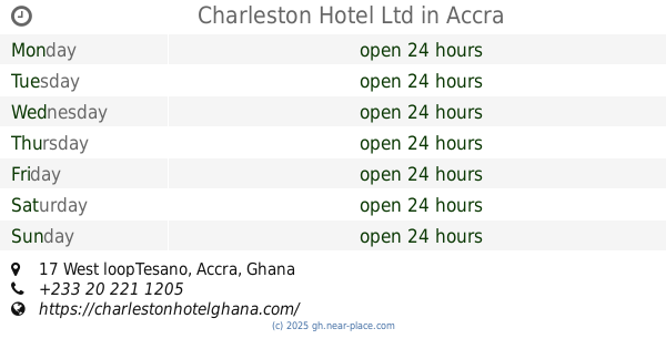
1.957 km
Charleston Hotel Ltd
17 West loopTesano, Accra
Lodging
read more
📑
all categories
Accounting
Administrative area level 1
Administrative area level 2
Airport
Amusement park
Aquarium
Art gallery
Atm
Bakery
Bank
Bar
Beauty salon
Bicycle store
Book store
Bus station
Cafe
Campground
Car dealer
Car rental
Car repair
Car wash
Casino
Cemetery
Church
City hall
Clothing store
Colloquial area
Convenience store
Courthouse
Dentist
Department store
Doctor
Electrician
Electronics store
Embassy
Finance
Fire station
Florist
Food
Funeral home
Furniture store
Gas station
General contractor
Grocery or supermarket
Gym
Hair care
Hardware store
Health
Hindu Temple
Home goods store
Hospital
Insurance agency
Intersection
Jewelry store
Laundry
Lawyer
Library
Liquor store
Local government office
Locality
Locksmith
Lodging
Meal delivery
Meal takeaway
Mosque
Movie rental
Movie theater
Moving company
Museum
Natural feature
Neighborhood
Night club
Painter
Park
Parking
Pet store
Pharmacy
Physiotherapist
Place of worship
Plumber
Point of interest
Police
Post office
Premise
Real estate agency
Restaurant
Roofing contractor
Route
Rv park, camping
School
Shoe store
Shopping mall
Spa
Stadium
Storage
Store
Subpremise
Subway station
Supermarket
Synagogue
Taxi stand
Train station
Transit station
Travel agency
University
Veterinary care
Zoo
sublocality level 1
↑