School nearby Mustard Seed School
Ghana
School nearby Mustard Seed School
Mustard Seed School
Taifa, Ghana
contacts phone
:
+233 57 265 2142
website:
www.mustardseedschoolgh.net
Latitude:
5.650161
, Longitude:
-0.2484557
larger map & directions
read more
nearest School
206 m
Star Of The East School
Cfc Estates, Taifa
School
read more
526 m
Garden Of Eden School
Taifa
School
read more
536 m
Little Bud International School
Cfc Estates, Taifa
School
read more
579 m
Silicon Valley International Sch.
Ghana
School
read more
764 m
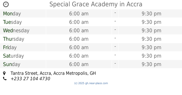
Special Grace Academy
Tantra Street, Accra
School
read more
770 m
Christian IPS Senior High School
Nsawam Road, Taifa
School
read more
797 m
Takyi Campus
Ghana
School
read more
841 m
Living Spring Montessori
Speedy Street, Taifa
School
read more
1.224 km
Rising Sun Montessori School - DOME
Taifa
School
read more
1.274 km
Start-Rite School
Greenhill Street, Taifa
School
read more
1.295 km
Bright Lilies School
Saint Johns - Dome - Kwabenya - Brekusu Road, Taifa
School
read more
1.31 km
Little Legend Preschool
Accra
School
read more
1.331 km
Tema Sec Sch
Saint Johns - Dome - Kwabenya - Brekusu Road, Accra
School
read more
1.382 km
St Johns Grammar School
School
read more
1.498 km
Hamburg International School
Parakuo Boundary Road, Accra
School
read more
1.504 km
Mount Mary Schools
Taifa
School
read more
1.547 km
Shalom International School
Taifa
School
read more
1.654 km
Nobles' Montessori
34 Royal Avenue, off Ansu Link
School
read more
1.69 km
Ghanaian Child School
Ofankor
School
read more
1.772 km
Sensels School
Taifa
School
read more
1.828 km
Cosmos Camp Of Technology
Ghana
School
read more
1.861 km
White Dove School Complex
Taifa
School
read more
2.115 km
Anglican School Ofankor
Taifa
School
read more
2.18 km
Liver Rose International School
Ghana
School
read more
2.629 km
St. John's Preparatory School
Accra
School
read more
📑
all categories
Accounting
Administrative area level 1
Administrative area level 2
Airport
Amusement park
Aquarium
Art gallery
Atm
Bakery
Bank
Bar
Beauty salon
Bicycle store
Book store
Bus station
Cafe
Campground
Car dealer
Car rental
Car repair
Car wash
Casino
Cemetery
Church
City hall
Clothing store
Colloquial area
Convenience store
Courthouse
Dentist
Department store
Doctor
Electrician
Electronics store
Embassy
Finance
Fire station
Florist
Food
Funeral home
Furniture store
Gas station
General contractor
Grocery or supermarket
Gym
Hair care
Hardware store
Health
Hindu Temple
Home goods store
Hospital
Insurance agency
Intersection
Jewelry store
Laundry
Lawyer
Library
Liquor store
Local government office
Locality
Locksmith
Lodging
Meal delivery
Meal takeaway
Mosque
Movie rental
Movie theater
Moving company
Museum
Natural feature
Neighborhood
Night club
Painter
Park
Parking
Pet store
Pharmacy
Physiotherapist
Place of worship
Plumber
Point of interest
Police
Post office
Premise
Real estate agency
Restaurant
Roofing contractor
Route
Rv park, camping
School
Shoe store
Shopping mall
Spa
Stadium
Storage
Store
Subpremise
Subway station
Supermarket
Synagogue
Taxi stand
Train station
Transit station
Travel agency
University
Veterinary care
Zoo
sublocality level 1
↑