Bar nearby Figure One Four
Ghana
Bar nearby Figure One Four
Figure One Four
Burma Camp, Accra Ghana
contacts phone
:
+233
Latitude:
5.5981731
, Longitude:
-0.1574859
read more
nearest Bar
74 m
Abotare Spot
air force market
Bar
read more
1.491 km
Burma Camp Polo Club
Accra
Bar
read more
1.652 km
Captain
Second Shippi Close, Accra
Bar
read more
1.788 km
Air Force Officers' Mess
2nd GIffard Lane, Accra
Bar
read more
1.997 km
Legends Pub
Unnamed Road, Accra
Bar
read more
2.125 km
Havana Cigar Lounge
Airport City, Accra
Bar
read more
2.198 km
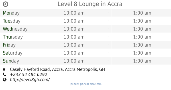
Level 8 Lounge
One, South liberation Link, Accra
Bar
read more
2.198 km
Level 8 Lounge
One, Casely Hayford Road, Accra
Bar
read more
2.217 km
Secrets Pub
Accra
Bar
read more
2.288 km
ibis Styles Accra Airport City Hotel
Plot 24 area Airport City Enclave, Accra
Bar
read more
2.29 km
ibis Styles Accra Airport City Hotel
area Airport City Enclave, Plot 24 Liberation Road, Accra
Bar
read more
2.522 km
Sweeties
Mama Adjele Road, Accra
Bar
read more
2.557 km
PARADISE INN
Kwakwranya Street, Accra
Bar
read more
2.571 km
Ab's Wine Shop
Ab's wine shop
Bar
read more
2.592 km
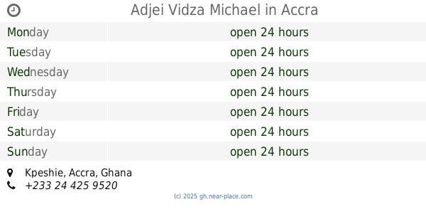
Adjei Vidza Michael
Accra
Bar
read more
2.649 km
Borga Spot
Accra
Bar
read more
2.776 km
RYMA SPOT
Labadi, Accra
Bar
read more
2.977 km
J Crown PUB
Labadi, Accra
Bar
read more
2.993 km
Elixir Bar
Dade Street, Accra
Bar
read more
3.118 km
Smoke'n Barrel
42 dade st, labone, Accra
Bar
read more
3.148 km
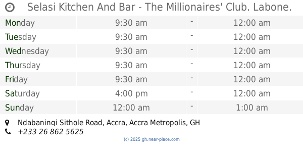
Selasi kitchen and bar - The Millionaires club
Ndabaningi Sithole Road, Accra
Bar
read more
3.148 km
Selasi Kitchen And Bar - The Millionaires' Club. Labone.
Ndabaningi Sithole Road, Accra
Bar
read more
3.282 km
GoldCoast Barbeque
Labone, Accra
Bar
read more
3.305 km
AM&PM
Accra
Bar
read more
3.669 km
Ato's Place
16 North Airport Road, Accra
Bar
read more
📑
all categories
Accounting
Administrative area level 1
Administrative area level 2
Airport
Amusement park
Aquarium
Art gallery
Atm
Bakery
Bank
Bar
Beauty salon
Bicycle store
Book store
Bus station
Cafe
Campground
Car dealer
Car rental
Car repair
Car wash
Casino
Cemetery
Church
City hall
Clothing store
Colloquial area
Convenience store
Courthouse
Dentist
Department store
Doctor
Electrician
Electronics store
Embassy
Finance
Fire station
Florist
Food
Funeral home
Furniture store
Gas station
General contractor
Grocery or supermarket
Gym
Hair care
Hardware store
Health
Hindu Temple
Home goods store
Hospital
Insurance agency
Intersection
Jewelry store
Laundry
Lawyer
Library
Liquor store
Local government office
Locality
Locksmith
Lodging
Meal delivery
Meal takeaway
Mosque
Movie rental
Movie theater
Moving company
Museum
Natural feature
Neighborhood
Night club
Painter
Park
Parking
Pet store
Pharmacy
Physiotherapist
Place of worship
Plumber
Point of interest
Police
Post office
Premise
Real estate agency
Restaurant
Roofing contractor
Route
Rv park, camping
School
Shoe store
Shopping mall
Spa
Stadium
Storage
Store
Subpremise
Subway station
Supermarket
Synagogue
Taxi stand
Train station
Transit station
Travel agency
University
Veterinary care
Zoo
sublocality level 1
↑